north pgh
-
Posts
3,012 -
Joined
-
Last visited
Content Type
Profiles
Blogs
Forums
American Weather
Media Demo
Store
Gallery
Everything posted by north pgh
-

Pittsburgh, Pa Winter 2023-24 Thread.
north pgh replied to meatwad's topic in Upstate New York/Pennsylvania
I remember a band like that over me in January of 2004 that dropped 4 inches in 3 hours. 5 to 10 miles from here the stars were out. -
Pittsburgh, Pa Winter 2023-24 Thread.
north pgh replied to meatwad's topic in Upstate New York/Pennsylvania
That band looks similar to the band that went into Orchard Park New York last weekend. -
Pittsburgh, Pa Winter 2023-24 Thread.
north pgh replied to meatwad's topic in Upstate New York/Pennsylvania
Starting to come down here now. Nice and heavy -
Pittsburgh, Pa Winter 2023-24 Thread.
north pgh replied to meatwad's topic in Upstate New York/Pennsylvania
Are you in Cranberry too? -
Pittsburgh, Pa Winter 2023-24 Thread.
north pgh replied to meatwad's topic in Upstate New York/Pennsylvania
Take it to the banter please. I want to concentrate on the heavier snow showers moving in. -
Pittsburgh, Pa Winter 2023-24 Thread.
north pgh replied to meatwad's topic in Upstate New York/Pennsylvania
It looks like those heavier snow showers are heading toward the airport. Maybe they can pick up another inch or so to get them over the 3 mark. -
Pittsburgh, Pa Winter 2023-24 Thread.
north pgh replied to meatwad's topic in Upstate New York/Pennsylvania
Yes they will be scattered but maybe we can get some into our area so we can pick up a burst or get a good squall. -
Pittsburgh, Pa Winter 2023-24 Thread.
north pgh replied to meatwad's topic in Upstate New York/Pennsylvania
I think this storm is performing exactly as I thought. Coming up on 3 inches. If I get one more that will be 4. Long duration light snow. Looks beautiful -
Pittsburgh, Pa Winter 2023-24 Thread.
north pgh replied to meatwad's topic in Upstate New York/Pennsylvania
speed: -
Pittsburgh, Pa Winter 2023-24 Thread.
north pgh replied to meatwad's topic in Upstate New York/Pennsylvania
Much like a clipper which gives us some of the nicest snowfalls. -
Pittsburgh, Pa Winter 2023-24 Thread.
north pgh replied to meatwad's topic in Upstate New York/Pennsylvania
The Joe Denardo rule. This is why you "Don't come out with accumulations numbers until 48 hours before the event." -
Pittsburgh, Pa Winter 2023-24 Thread.
north pgh replied to meatwad's topic in Upstate New York/Pennsylvania
A solid 3 or 3.5 of fluffy stuff. Good ratios helped us to over perform. -
Pittsburgh, Pa Winter 2023-24 Thread.
north pgh replied to meatwad's topic in Upstate New York/Pennsylvania
Anyone on the board getting any snow yet? Radar looking good from south to north. County airport reporting light snow. -
Pittsburgh, Pa Winter 2023-24 Thread.
north pgh replied to meatwad's topic in Upstate New York/Pennsylvania
I do not like overnight snowfalls. You go to sleep and it snows and you wake up and it is on the ground but just about over. I like to see the snow falling during the day like last week. . -
Pittsburgh, Pa Winter 2023-24 Thread.
north pgh replied to meatwad's topic in Upstate New York/Pennsylvania
Sleet has moved in here as well. My temp is 42 -
Pittsburgh, Pa Winter 2023-24 Thread.
north pgh replied to meatwad's topic in Upstate New York/Pennsylvania
As of now the Euro is the only bad model for us for Tuesday. I think we are in a good spot now. Things will change this weekend. We know it could go either way but I'd rather have more models in our favor now than not. -
Pittsburgh, Pa Winter 2023-24 Thread.
north pgh replied to meatwad's topic in Upstate New York/Pennsylvania
OZ for Monday Canadian looks good. GFS no good. -
Pittsburgh, Pa Winter 2023-24 Thread.
north pgh replied to meatwad's topic in Upstate New York/Pennsylvania
Picked up a quick inch earlier. Switched to rain around 6:30 and turned back to snow in the last hour hour and a half. Now it is mainly sleet. I am at a nice elevation and was traveling towards north park and roads are horrible. -
Pittsburgh, Pa Winter 2023-24 Thread.
north pgh replied to meatwad's topic in Upstate New York/Pennsylvania
It was good to see the little ones out playing in the snow this afternoon. I saw 3 snowmen built today. -
Pittsburgh, Pa Winter 2023-24 Thread.
north pgh replied to meatwad's topic in Upstate New York/Pennsylvania
Nice back end building here -
Pittsburgh, Pa Winter 2023-24 Thread.
north pgh replied to meatwad's topic in Upstate New York/Pennsylvania
Heavy rates in the North Hills. Go take a walk and feel like a kid again. Beautiful. Enjoy it. -
Pittsburgh, Pa Winter 2023-24 Thread.
north pgh replied to meatwad's topic in Upstate New York/Pennsylvania
Funny I just had KDKA on the radio and they are going with a big downgrade from 3-6 at the beginning of the week to maybe an inch tomorrow. You can tell they still have old data. -
Pittsburgh, Pa Winter 2023-24 Thread.
north pgh replied to meatwad's topic in Upstate New York/Pennsylvania
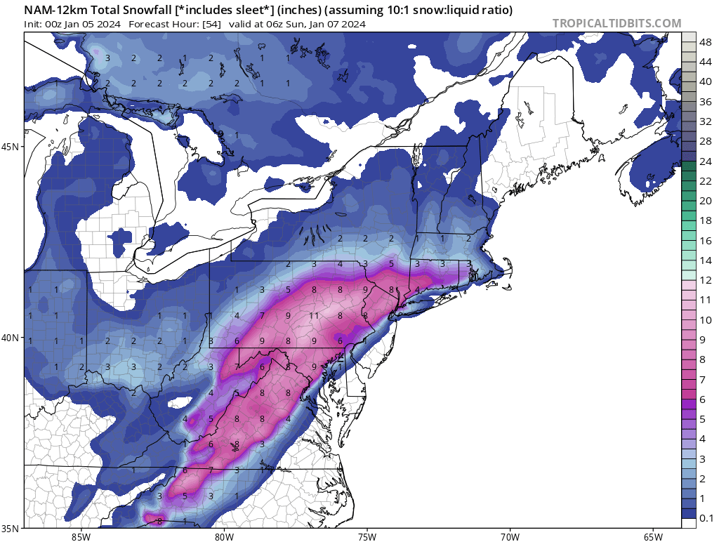
-
Pittsburgh, Pa Winter 2023-24 Thread.
north pgh replied to meatwad's topic in Upstate New York/Pennsylvania
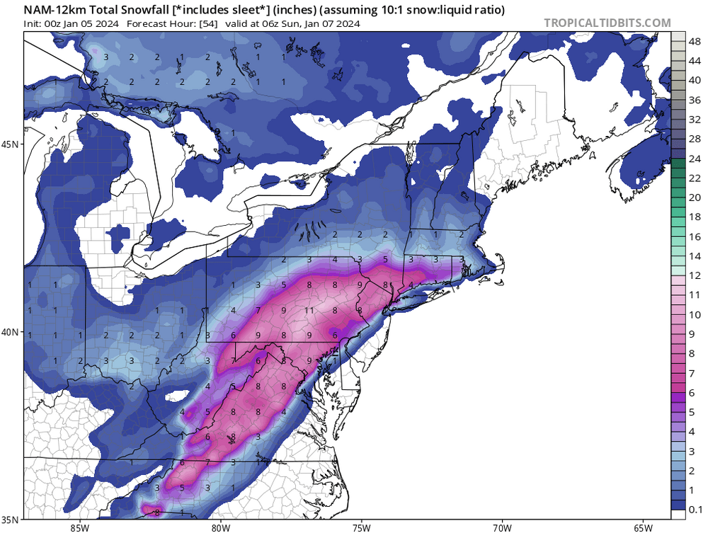
-
Pittsburgh, Pa Winter 2023-24 Thread.
north pgh replied to meatwad's topic in Upstate New York/Pennsylvania
I say screw the models. This is the only one giving us some snow. https://www.tropicaltidbits.com/analysis/models/?model=hrrr®ion=neus&pkg=ref_frzn&runtime=2024010500&fh=2