

CoastalWx
-
Posts
177,447 -
Joined
-
Last visited
Content Type
Profiles
Blogs
Forums
American Weather
Media Demo
Store
Gallery
Everything posted by CoastalWx
-
Man that is tasty on the euro.
-
Here comes the euro for Monday.
-
That would be darn wintry verbatim if that occurred. Talking near mid month.
-
And part of the PV is over nrn Hudson Bay.
-
But but but 1000" elevation.
-
Pretty sweet GEFS look.
-
Reading had 8.5". Not bad for a forecast of cirrus.
-
Wasn't really a CJ, just a 1-3" event that turned into a foot of fluff.
-
Funny how Jerry and I have an affinity for the 12/29/93 event.
-
It's a shame we missed the late March bomb in 2014. That would have been pretty dam epic. Locally it was a good winter here.
-
Had a few quick downpours earlier. Getting windy now. 55.
-
Guidance is all over. GEFS looks like the have two camps. Timing differences with the s/w's.
-
13-14 had some moments too. It also had pack assassination.
-
Leon!
-
12z GFS is a beast just offshore on the weekend.
-
I don't see why there has been so much doom and gloom last few days. Other than the typical weenie banter, can someone point me to a big red flag? What is pointing to a ratter? What's wrong with near avg snow in December? I don't see an obvious feature showing me that we are in for a crap month. Trust me, I always tend to look for problems down the road...but nothing really stands out. I do think we may need patience into mid month (that does not mean we can't sneak something), but I don't see anything that makes me want to throw my laptop into the Atlantic.
-
Has anybody ever seen the extended GEFS out to 35 days? LOL...I don't think the met community cares one bit for that. What a shame, all that money wasted on that project...can think of many other areas where it could have been spent more wisely.
-
I said last week that second half of the month looked to be heading to more Nina look. But that doesn't mean shorts on Christmas.
-
I just meant that I think the potential for anything interesting this weekend is gone.
-
Yeah seems to be some connection WRT height as you said.
-
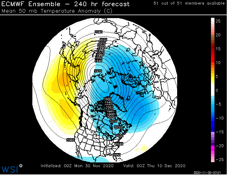
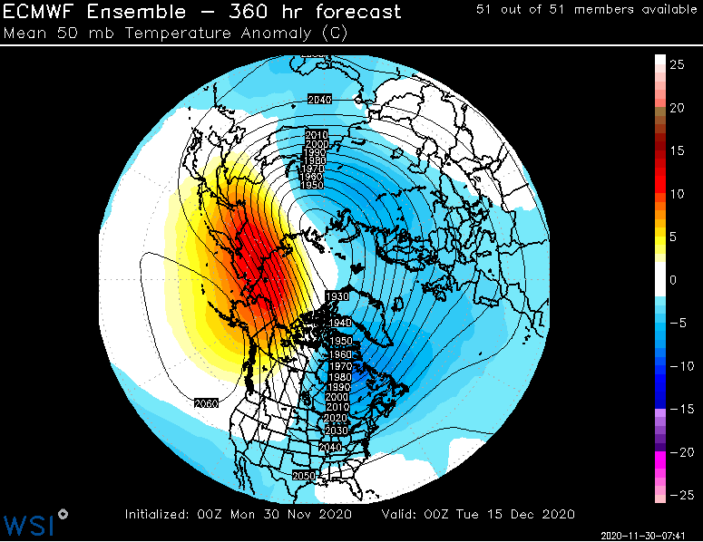
FWIW 10mb gets quite a punch too, but may as well as the folks at the ISS what the temperature is out that way. I don't look that high typically.
-
This is encouraging to see. Certainly good to have to prevent a pig anyways. The 50mb vortex getting some jabs.
-
May have to watch 12/7. Some hints on guidance from that and not as voodoo as this weekends deal or lack thereof.
-
I was just having fun. It may get a little more gradient, but we'll have money in the bank then. There is no pig.
-
Hadley Cell gonna eat you up.


