

CoastalWx
-
Posts
177,399 -
Joined
-
Last visited
Content Type
Profiles
Blogs
Forums
American Weather
Media Demo
Store
Gallery
Everything posted by CoastalWx
-
You guys do it to yourselves.
-
I don't know, I haven't seen that here? Are you on Pete's forum?
-
It should get cold enough eventually.
-
He's too busy checking in beers on Untappd
-
I think you see a lot of amplifications of this Probably a good pattern to try and grab your vaunted elevation event.
-
Yep, those are pretty handy IMO.
-
That tells me to toss the AO and NAO forecasts of the GEFS. They are verifying much more + vs the forecast.
-
It's possible one of those cutoffs does deliver in the mtns or somewhere in the deep south. I could see that.
-
The gift that keeps on giving.
-
Not this year, Holidays are a bust. Torch it for T-Day, can reevaluate for Christmas.
-
Ray are you kidding or serious?
-
Christmas I get, but who cares for Thanksgiving?
-
Seasons in seasons! I'm hoping it's at least in the 50s here, but even that may not happen.
-
Live free or slide tomorrow afternoon.
-
That would be a long shot on the EPS. You'd need perfect timing. Anyways, EPS has a threat still (although gut says low chance) to start the month in New England.
-
Just looked on radar and higher tilts from BTV looked good for more than an inch that’s for sure.
-
We’re past that I’m sure. Not to say that can’t happen, but that stretch of virtually 3 seasons where you guys were fringed, probably won’t be repeated for awhile.
-
You and Phin praying for the ARW model cores to be right.
-
Epic rainbow.
-
I said the same. I certainly did not expect that.
-
-
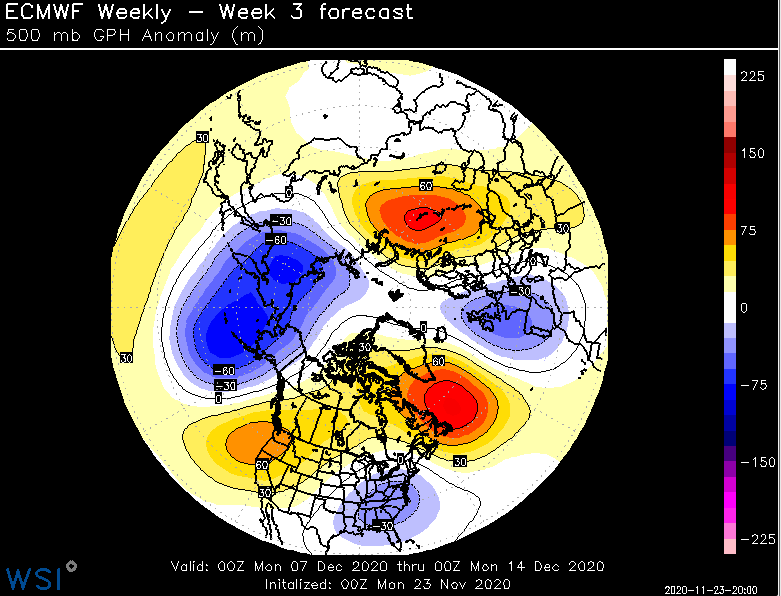
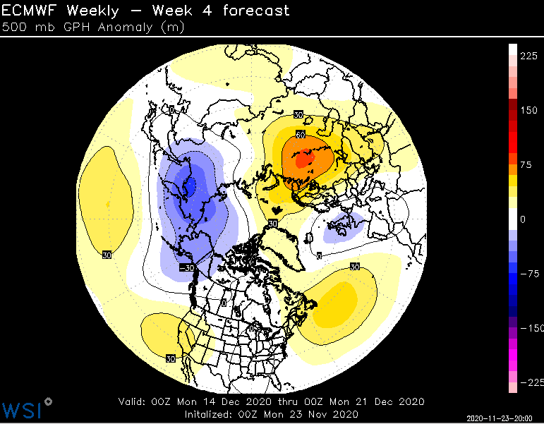
No surprise, weeklies are a big change. Week 3 has more of a +PNA with Davis Straits ridge. Week 4 tries to get some lower heights into AK again, but ridging into the SW US and leftover ridging off Labrador.
-
Looks like we have a wave train before things shift around later in the 11-15 day.
-
More like Brooklyn and Bolton Landing. Tony rolls his window down in his patrol car, and piles of hotdogs roll out along with this laptop stuck at hr 240 on the euro op.
-


