CoastalWx
-
Posts
177,391 -
Joined
-
Last visited
Content Type
Profiles
Blogs
Forums
American Weather
Media Demo
Store
Gallery
Everything posted by CoastalWx
-
Some models had that, but filled it on later on.
-
Active mid December with multiple event potential
CoastalWx replied to Typhoon Tip's topic in New England
When something happens in south central CT. Nothing happens.....it’s just another weenie dead. -
Active mid December with multiple event potential
CoastalWx replied to Typhoon Tip's topic in New England
Ant like Hank Voit? -
Active mid December with multiple event potential
CoastalWx replied to Typhoon Tip's topic in New England
Do some donuts in the cruiser, Ant. -
Active mid December with multiple event potential
CoastalWx replied to Typhoon Tip's topic in New England
We have been trying and trying and trying to tell them. -
Active mid December with multiple event potential
CoastalWx replied to Typhoon Tip's topic in New England
That's where we joke about the PF currier and ives band, it's like 600mb many times. All those times where we said that you would get decent snows...it was from the area above 700. Sometimes looking at 500mb VVs will help you interpolate between 700 and 500 to get an idea. You can also look at the temps at those levels to get an idea of roughly where the -12 to -18c layer is. -
Active mid December with multiple event potential
CoastalWx replied to Typhoon Tip's topic in New England
That is a nice signal for hippy and radarman, Ineedsnow etc. Nice. -
Active mid December with multiple event potential
CoastalWx replied to Typhoon Tip's topic in New England
GFS is great with the CCB too. Good run all around. -
Active mid December with multiple event potential
CoastalWx replied to Typhoon Tip's topic in New England
I guess I just think you’re in a good spot. Maybe not jack, but not he pork job you feared yesterday. -
Active mid December with multiple event potential
CoastalWx replied to Typhoon Tip's topic in New England
This run is mid level magic for berks ENE into SNH. Maybe tickling Ray. This is why we do not give out certainties with subbies. -
Active mid December with multiple event potential
CoastalWx replied to Typhoon Tip's topic in New England
Yeah a second one somewhere there, but I do think that area Just N and W of BOS may have a narrow enhancement for a time before it moves SE after 10z or so. -
Active mid December with multiple event potential
CoastalWx replied to Typhoon Tip's topic in New England
CJ (well the CF) is sort of moving. Really need that to remain in place for hours. The mid level goodies people will jack. I'm just happy to get a good storm. Haha. -
Active mid December with multiple event potential
CoastalWx replied to Typhoon Tip's topic in New England
I think it looks great up there. -
Active mid December with multiple event potential
CoastalWx replied to Typhoon Tip's topic in New England
I like that Ray is pulling an "it's a wonderful life" and coming off the bridge. -
Active mid December with multiple event potential
CoastalWx replied to Typhoon Tip's topic in New England
Euro slams the WCB. Finally. -
Active mid December with multiple event potential
CoastalWx replied to Typhoon Tip's topic in New England
Just FYI this is still experimental. But some FB hero mets are pimping it out I guess. -
Active mid December with multiple event potential
CoastalWx replied to Typhoon Tip's topic in New England
Algorithm is whack. -
Active mid December with multiple event potential
CoastalWx replied to Typhoon Tip's topic in New England
That map looks strange from the Ukie. -
Active mid December with multiple event potential
CoastalWx replied to Typhoon Tip's topic in New England
weather.cod has regional sectors. -
Active mid December with multiple event potential
CoastalWx replied to Typhoon Tip's topic in New England
I think you are in a good spot. -
Active mid December with multiple event potential
CoastalWx replied to Typhoon Tip's topic in New England
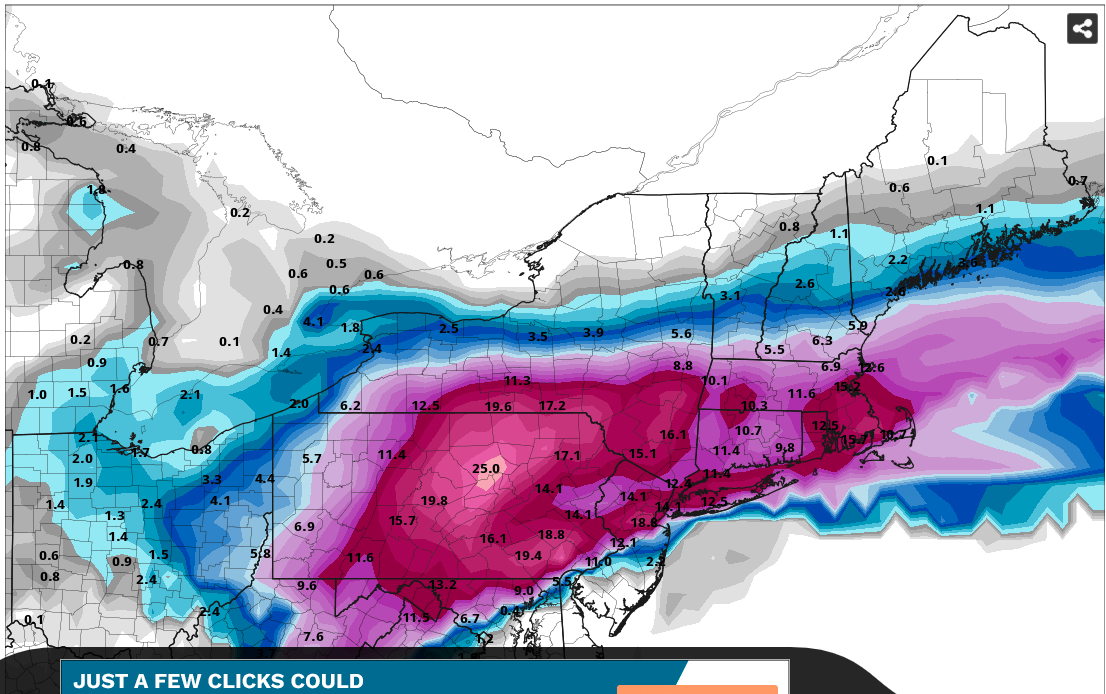
Queens need to remember mid level tracks will raise those amounts near NH border to CON or so.
-
Active mid December with multiple event potential
CoastalWx replied to Typhoon Tip's topic in New England
I don't see subby stuff on the globals. Wonder if that is a hi res issue. -
Active mid December with multiple event potential
CoastalWx replied to Typhoon Tip's topic in New England
12z GFS looks real good in all areas. -
Active mid December with multiple event potential
CoastalWx replied to Typhoon Tip's topic in New England
Ever watch Yellowstone? They just get shot. -
Active mid December with multiple event potential
CoastalWx replied to Typhoon Tip's topic in New England
To answer Jay’s question, I think 9-13 will do it here.