CoastalWx
-
Posts
177,391 -
Joined
-
Last visited
Content Type
Profiles
Blogs
Forums
American Weather
Media Demo
Store
Gallery
Everything posted by CoastalWx
-
Active mid December with multiple event potential
CoastalWx replied to Typhoon Tip's topic in New England
Reggie looks a little more amped from 18z. Just a tad. -
Active mid December with multiple event potential
CoastalWx replied to Typhoon Tip's topic in New England
I like the cross sections on TT with the fronto stuff. Pretty classic to see the good fronto and lift into DGZ just NW of it.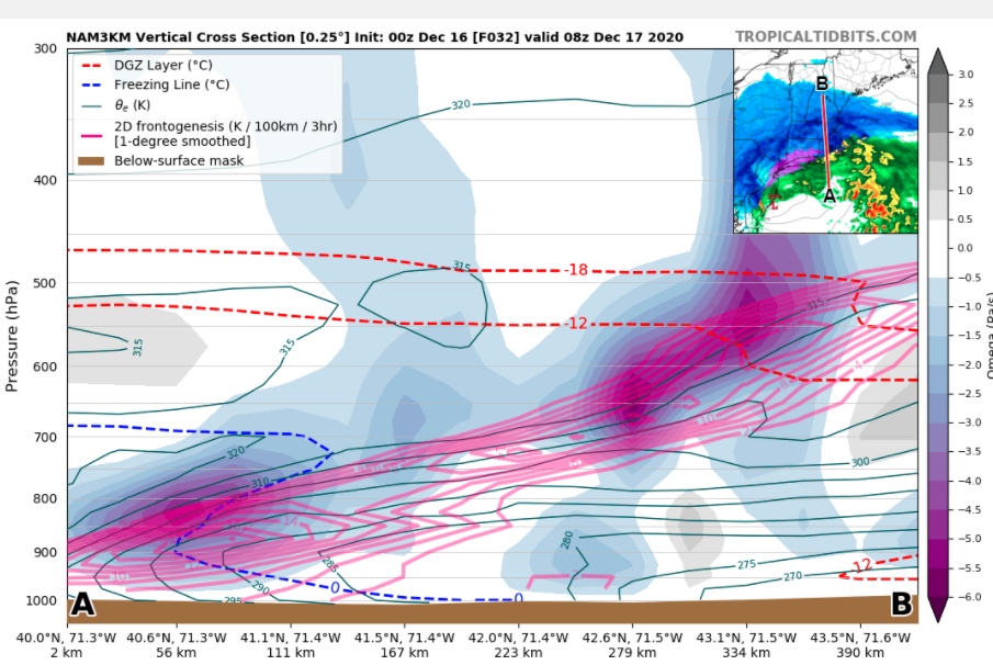
-
Active mid December with multiple event potential
CoastalWx replied to Typhoon Tip's topic in New England
Oh my bad Ray. -
Active mid December with multiple event potential
CoastalWx replied to Typhoon Tip's topic in New England
Pivotal weather?
-
Active mid December with multiple event potential
CoastalWx replied to Typhoon Tip's topic in New England
I was looking at the 700 low placement. -
Active mid December with multiple event potential
CoastalWx replied to Typhoon Tip's topic in New England
That was a good one. -
Active mid December with multiple event potential
CoastalWx replied to Typhoon Tip's topic in New England
H7 was definitely further south. One more tick south and Ray is taking Abercrombie Christmas Catalog photos. -
Active mid December with multiple event potential
CoastalWx replied to Typhoon Tip's topic in New England
Yeah seems that way. More moisture influx. -
Active mid December with multiple event potential
CoastalWx replied to Typhoon Tip's topic in New England
NAM is crushing SNE at 6z and beyond. -
Active mid December with multiple event potential
CoastalWx replied to Typhoon Tip's topic in New England
Likely delays, probably some cancellations. -
Active mid December with multiple event potential
CoastalWx replied to Typhoon Tip's topic in New England
I think it’s the confidence issue, but you probably should be. -
Active mid December with multiple event potential
CoastalWx replied to Typhoon Tip's topic in New England
We love -
Active mid December with multiple event potential
CoastalWx replied to Typhoon Tip's topic in New England
For all. -
Active mid December with multiple event potential
CoastalWx replied to Typhoon Tip's topic in New England
18z eps looks good. -
Active mid December with multiple event potential
CoastalWx replied to Typhoon Tip's topic in New England
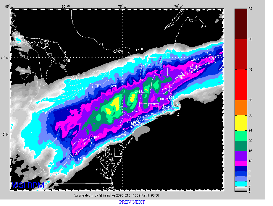
What a storm. There was about 2’ where I am now. I had 17” iirc in Dorchester. -
Active mid December with multiple event potential
CoastalWx replied to Typhoon Tip's topic in New England
I just looked at BOS. -
Active mid December with multiple event potential
CoastalWx replied to Typhoon Tip's topic in New England
LOL, it may be wrong, but it isn't outrageous. 6-9 for BOS is outrageous? -
Active mid December with multiple event potential
CoastalWx replied to Typhoon Tip's topic in New England
It's not outrageous. If it trends warmer or NW, then it will be right. -
Active mid December with multiple event potential
CoastalWx replied to Typhoon Tip's topic in New England
That run was a little better here. Snows into Thursday evening. -
Active mid December with multiple event potential
CoastalWx replied to Typhoon Tip's topic in New England
Yeah so strange. Agree Thursday morning looks good. -
Active mid December with multiple event potential
CoastalWx replied to Typhoon Tip's topic in New England
Meh nothing reallY notable on euro. Loving the offshore convection. -
Active mid December with multiple event potential
CoastalWx replied to Typhoon Tip's topic in New England
It does have a topographic fetish. -
Active mid December with multiple event potential
CoastalWx replied to Typhoon Tip's topic in New England
I just don’t exactly understand why the gulf. More of the uncertainty is out west. -
Active mid December with multiple event potential
CoastalWx replied to Typhoon Tip's topic in New England
I want a Mar 2019 blob moving over my fanny. -
Active mid December with multiple event potential
CoastalWx replied to Typhoon Tip's topic in New England