

CoastalWx
-
Posts
177,425 -
Joined
-
Last visited
Content Type
Profiles
Blogs
Forums
American Weather
Media Demo
Store
Gallery
Everything posted by CoastalWx
-
Significant upper middle Atlantic S/CNE mix/snow potential Jan 3+
CoastalWx replied to Typhoon Tip's topic in New England
Looks like RA/SN like over Braintree/Quincy border. About 2.5 miles NW.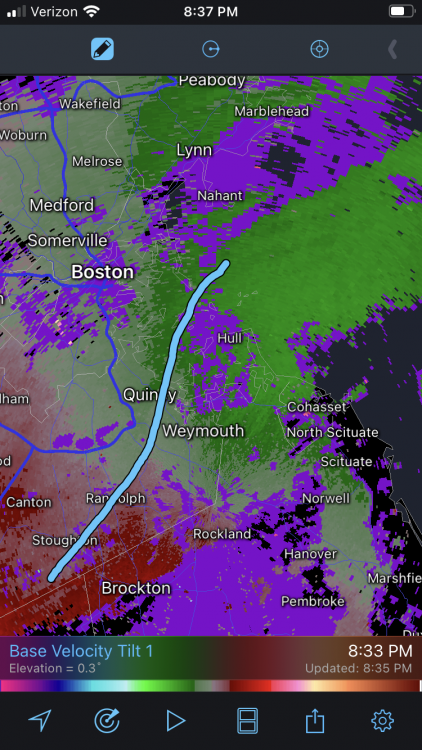
-
Significant upper middle Atlantic S/CNE mix/snow potential Jan 3+
CoastalWx replied to Typhoon Tip's topic in New England
Guidance pretty good with that. Blah. -
Significant upper middle Atlantic S/CNE mix/snow potential Jan 3+
CoastalWx replied to Typhoon Tip's topic in New England
Remember when the euro had a month’s worth of QPF on the cape at 18z yesterday? Fail of all fails. Pretty sure it ****ed Nova Scotia too. -
Significant upper middle Atlantic S/CNE mix/snow potential Jan 3+
CoastalWx replied to Typhoon Tip's topic in New England
Nah not convective like that. I don’t mean banded, it’s literally cellular. -
Significant upper middle Atlantic S/CNE mix/snow potential Jan 3+
CoastalWx replied to Typhoon Tip's topic in New England
Might grab a local 1-2 there. -
Significant upper middle Atlantic S/CNE mix/snow potential Jan 3+
CoastalWx replied to Typhoon Tip's topic in New England
I honestly don’t think I’ve ever seen a radar so shredded like this. It’s not meant to poo poo or anything like that. From a met standpoint, that’s hard to do. Usually you have a solid band of rather moderate or greater echoes. -
Significant upper middle Atlantic S/CNE mix/snow potential Jan 3+
CoastalWx replied to Typhoon Tip's topic in New England
Nothing? Just noting. -
Significant upper middle Atlantic S/CNE mix/snow potential Jan 3+
CoastalWx replied to Typhoon Tip's topic in New England
?? Radar is atrocious. Compare the radar with any other pedestrian event and it’s night and day even from that. You aren’t supposed to have no echoes near to 30DBZ echoes. -
Significant upper middle Atlantic S/CNE mix/snow potential Jan 3+
CoastalWx replied to Typhoon Tip's topic in New England
Well now that edibles are legal, expect some good obs. -
Significant upper middle Atlantic S/CNE mix/snow potential Jan 3+
CoastalWx replied to Typhoon Tip's topic in New England
You have areas of no DBZs and near 30DBZ. Swiss cheese. -
Significant upper middle Atlantic S/CNE mix/snow potential Jan 3+
CoastalWx replied to Typhoon Tip's topic in New England
Radar is terrible. That’s Swiss cheese and then some. -
Significant upper middle Atlantic S/CNE mix/snow potential Jan 3+
CoastalWx replied to Typhoon Tip's topic in New England
And as mid levels show, best stuff heading into VT. -
Significant upper middle Atlantic S/CNE mix/snow potential Jan 3+
CoastalWx replied to Typhoon Tip's topic in New England
Ha, lightning in nrn NJ. You can tell it’s just a slotted mess. Probably some instability, but not deep RH. -
Significant upper middle Atlantic S/CNE mix/snow potential Jan 3+
CoastalWx replied to Typhoon Tip's topic in New England
Yeah especially other side of CF. -
Significant upper middle Atlantic S/CNE mix/snow potential Jan 3+
CoastalWx replied to Typhoon Tip's topic in New England
Probably poops out a bit. -
As one can see on the op runs, No shortage of tracking systems. We’ll have our chances. Honestly, not much more you can ask in winter.
-
I’ll take Stein if no snow. Too wet.
-
Significant upper middle Atlantic S/CNE mix/snow potential Jan 3+
CoastalWx replied to Typhoon Tip's topic in New England
Watches up by morning? -
When the 80s come ( and maybe they have given the last couple years), this place will be unreadable.
-
Significant upper middle Atlantic S/CNE mix/snow potential Jan 3+
CoastalWx replied to Typhoon Tip's topic in New England
I’m not bitching about the scenario, I’m calling out that awful performance from the euro. -
Significant upper middle Atlantic S/CNE mix/snow potential Jan 3+
CoastalWx replied to Typhoon Tip's topic in New England
Euro should be in that coffin. -
I mean people are having virtual fist fights, name calling.....what an embarrassment to this sub forum. Yet somehow I’m the one who melts.
-
Significant upper middle Atlantic S/CNE mix/snow potential Jan 3+
CoastalWx replied to Typhoon Tip's topic in New England
There isn’t a real -NAO yet though. Look at the height fields. -
People getting quite ridiculous over a week where nothing was progged to happen. Classic. Go hug your loved ones and come back next weekend.
-
Significant upper middle Atlantic S/CNE mix/snow potential Jan 3+
CoastalWx replied to Typhoon Tip's topic in New England
Well at least it’s snowing lightly here from OE.


