

Sey-Mour Snow
-
Posts
4,047 -
Joined
-
Last visited
Content Type
Profiles
Blogs
Forums
American Weather
Media Demo
Store
Gallery
Posts posted by Sey-Mour Snow
-
-
1 minute ago, MJO812 said:
My first winter storm warning since 2022.
4-8 inches
Really hope you do well
-
 1
1
-
-
6 minutes ago, Brian5671 said:
almost every model was in agreement last evening-that's 36 hrs out....
All but UKMET
-
2
-
-
3 minutes ago, Ginx snewx said:
Cmon
I'm stating the obvious here, not going out on a limb.. It's not a forecast I said if it ticks like that again ..
-
2 minutes ago, Ginx snewx said:
You will be fine. Christ you were worried yesterday about being it too far North
Might want to take off the weenie goggles.. You need a new prescription ..
-
1
-
 1
1
-
-
As expected the HRRR went well south east about 50 miles with the accumulating snow.. Still hits the south shore hard but one more shift like that and its game over for everyone..
-
1
-
-
HRRR coming in much less amped compared to 12z.. Will still be a hit for some, but if you continue that trend one more time for 00z its a shut out for all of SNE.. Also as many as said a light to moderate event wont accumulate with this crap air mass. Lost for words right now ..
-
1 hour ago, joey2002 said:
BOX isn’t buying the trend apparently or they’re just going with the HREF

Rolling with the 700mb goodies but the cutoff will be sharper than that
-
lol what the hell is going on? From a rt 2 jack to MJO jack in 18 hours on day 2! Congrats to MJO for joining the party let’s hope it stops trending south this is absolutely wild!
-
3
-
-
1 minute ago, RUNNAWAYICEBERG said:
Interesting developments. Okc has a big decision to make tomorrow morning for their coverage area.
NYC metro is a nightmare forecast 0 or 12” in spots with urban heat effect
-
2
-
-
Just now, 40/70 Benchmark said:
The Kuchie is absolutely more appropriate near the northern edge under H7 banding....to the south and near the coast, I agree.
Kuchie will be less than 10:1 in rain/snow situations ..
-
4 minutes ago, MJO812 said:
Less convection helping out ?
Could be a reason for lower heights on east coast . Earthlight mentioned it earlier and now I’m seeing how the tornado outbreak is busting
-
Wild the run to run differences on eps is the timing slowed down a lot for 36 hours out. The colder trends coincide with the slower trends. Also the warm front and tornado outbreak being shunted south today helping us out?
-
19 minutes ago, weatherwiz said:
I'm not so sure the difference is north/south as much as it is structural/evolution differences. It's easy to say there is a shift just comparing the snow maps (which is awful) and QPF maps, but there may be much more it to than just shifting.
Ya it’s colder and slower that’s it
-
 1
1
-
-
40 minutes ago, Ginx snewx said:
Are Sey-Mour and Luke finally putting away their toasters? PTSD boys
We replaced toasters with smiles
-
2
-
-
Just now, weatherwiz said:
Nicely done
-
1
-
1
-
-
2 minutes ago, Typhoon Tip said:
No, I think the people are focusing on details that are a little bit below expectation for what the guides are capable of doing - because they need to get the snow into their backyard very small movement seem very much bigger than they really are.
If we step back and look at it from a bigger, synoptic overview? Theres a decent short duration impactor that’s higher confidence - the changes are not significant to warrant whether that’s going to be the case or not
True so the smaller synoptic changes in the icon at a glance normally wouldn’t warrant the shift we are seeing in terms of precip and snowfall output you are saying?
-
1 minute ago, Typhoon Tip said:
Looking at the icon, and the GFS solutions over the past 36 hours I don’t really see that they’re variations from run to run significant enough to warrant much consideration
Icon has trended significantly south in 36 hours steadily it’s about 200 miles south with all features. GFS has been pretty steady with some north and south waffling currently in a south tic trend.
-
1
-
-
2 minutes ago, CoastalWx said:
I’ll lean 5-8 here. Could see higher west and above 200’ or so. I’m having trouble going higher locally. I suppose nam thermals would argue higher.
Think too warm boundary layer there?
-
1 minute ago, CoastalWx said:
Reggie has a great band look SW CT to metro BOS area N and S.
I can’t stop smiling since I saved Ginxys horse
-
 2
2
-
-
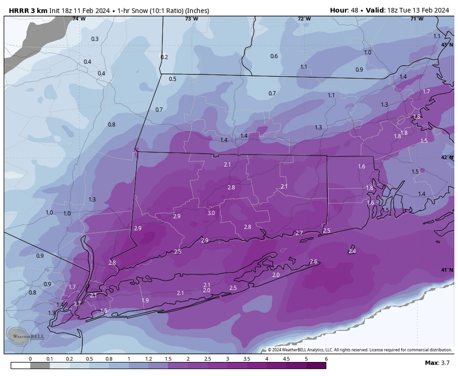
1 minute ago, TheSnowman said:
Hire is that THAT historic? We have had So many storms with that.
Thats 1 hour snow at 10:1 with a 3” band over the entire state of CT. That will never verify just fun to look at
-
@RUNNAWAYICEBERGcheck out long range hrrr . We’d make up for the past 10 years with that. Quasi stationary band setting up for our hood with 3-4” per hour rates at 10:1 lmao we will never see this again what’s weenie run
-
3
-
-
4 minutes ago, tavwtby said:
thought they got rid of temp criteria a while ago?
They did
-
2
-
-
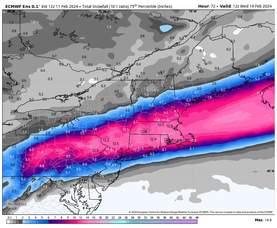
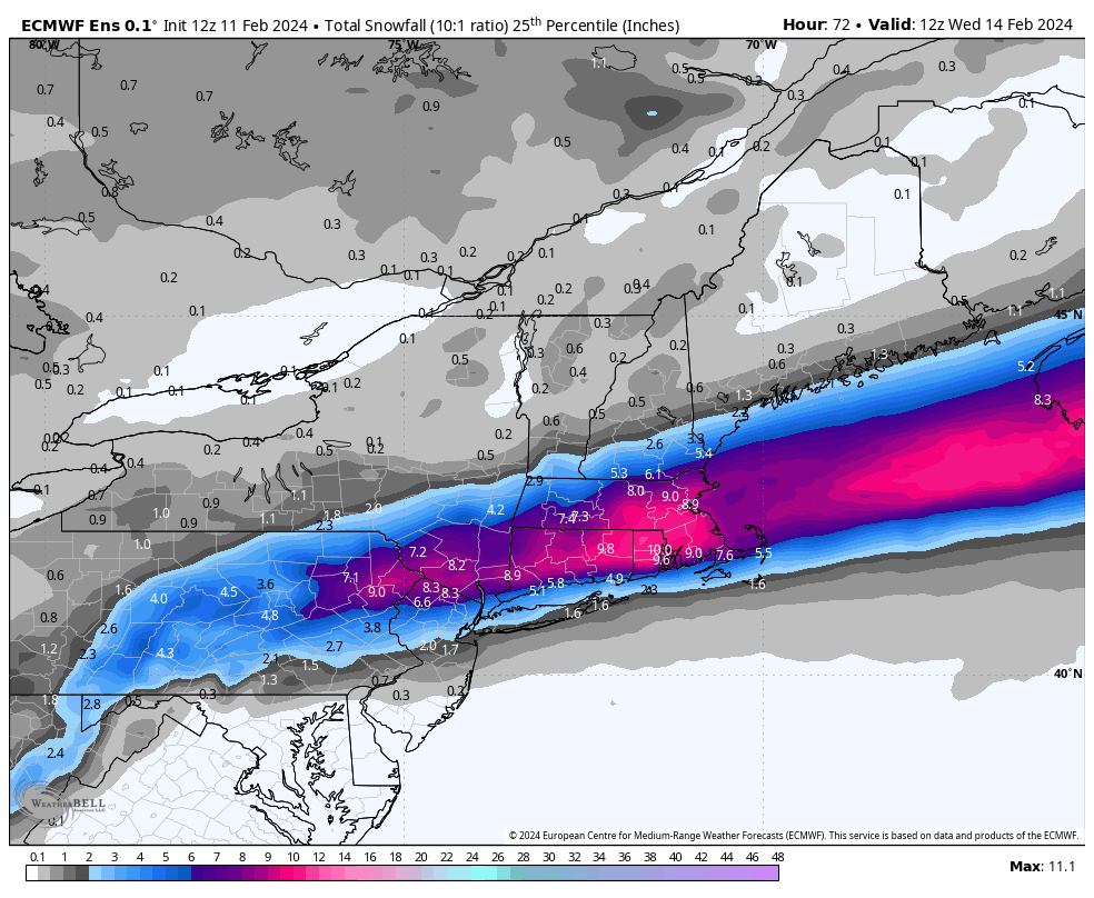
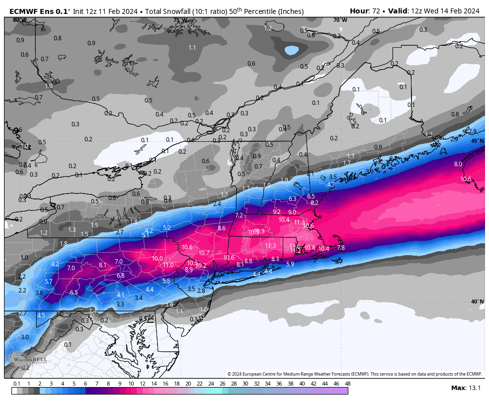
EPS much improved as well for SNE everything south again and delayed which has correlated to colder..
Kev to Scott 11-12" mean ..
Posted is 25th / 50th / 75th percentile .. That's about the least amount of variance I've seen in those for 48-60 hours


-
2
-
-
3 minutes ago, RUNNAWAYICEBERG said:
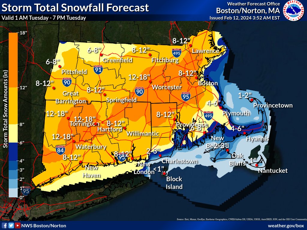
Regardless of clowns, it was good to see the mid levels not continue their march northward. I feel better hitting the 8 mark now.
Ya 700 moved south again by 50 miles
-
3
-
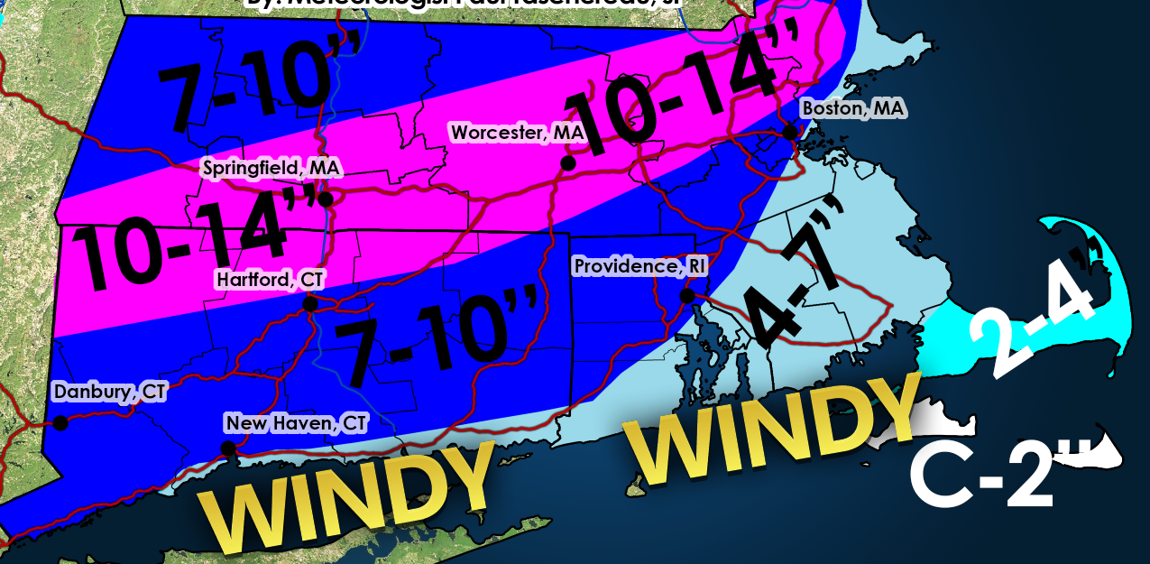


Following a Miller A/B hybrid type coastal potential, Feb 13th ... As yet untapped potential and a higher ceiling with this one
in New England
Posted
Been thinking the same thing all day