

Sey-Mour Snow
-
Posts
6,919 -
Joined
-
Last visited
Content Type
Profiles
Blogs
Forums
American Weather
Media Demo
Store
Gallery
Posts posted by Sey-Mour Snow
-
-
1 hour ago, dendrite said:
lol
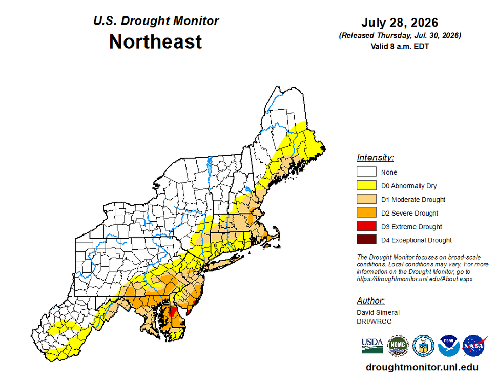
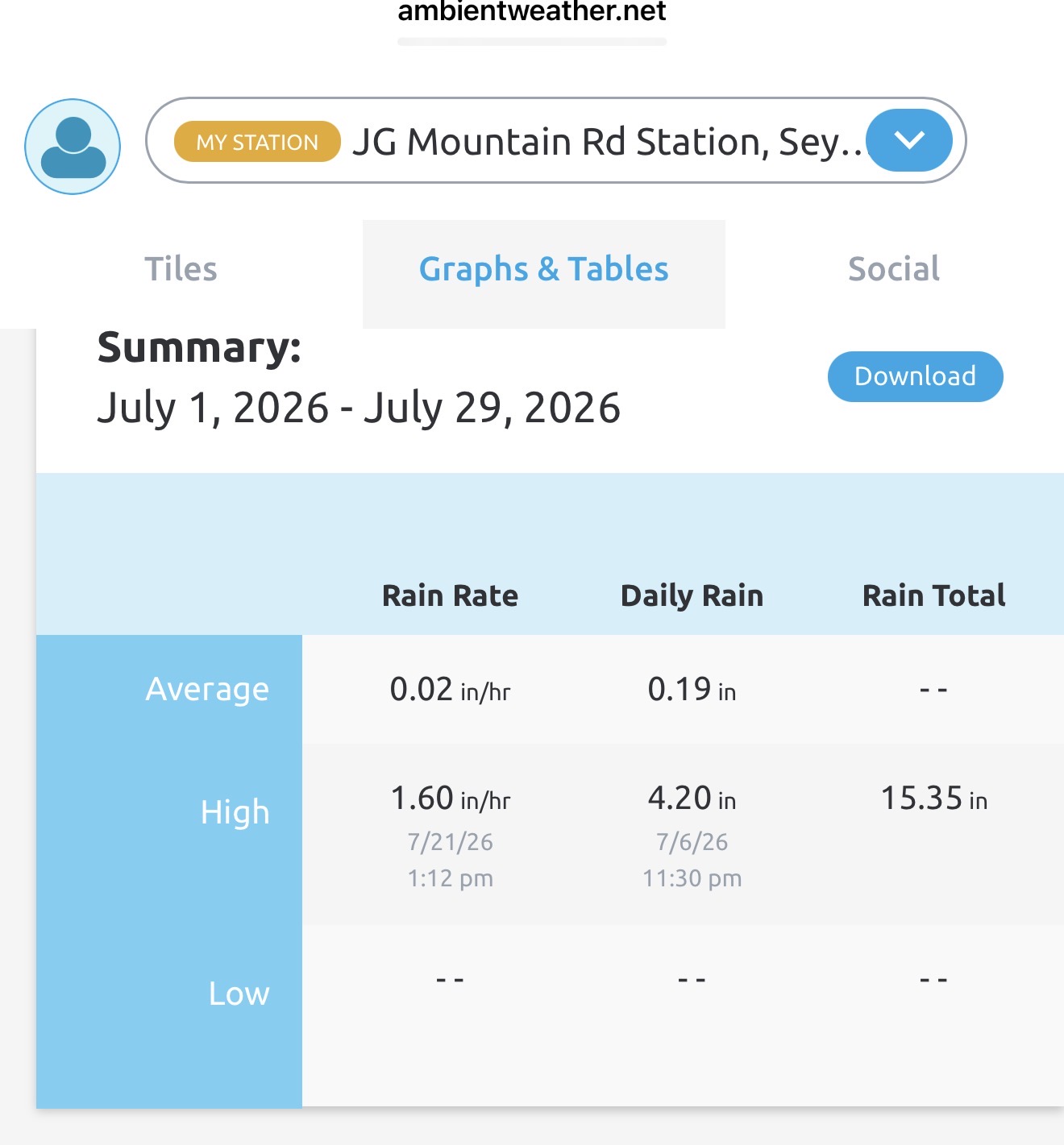
Purple jack over Seymour . Home wether station is 16.7” with more heavy rain moving in wild. August promises to start wet too maybe we remove all drough from southern CT.
-
 1
1
-
-
2 minutes ago, CoastalWx said:
Think near 15”.
-
 2
2
-
-
10 minutes ago, CoastalWx said:
how is that even possible? lol.
Ya it’s been a bit wet lol. Didn’t Kevin have a close to 20” July a few years back ?
-
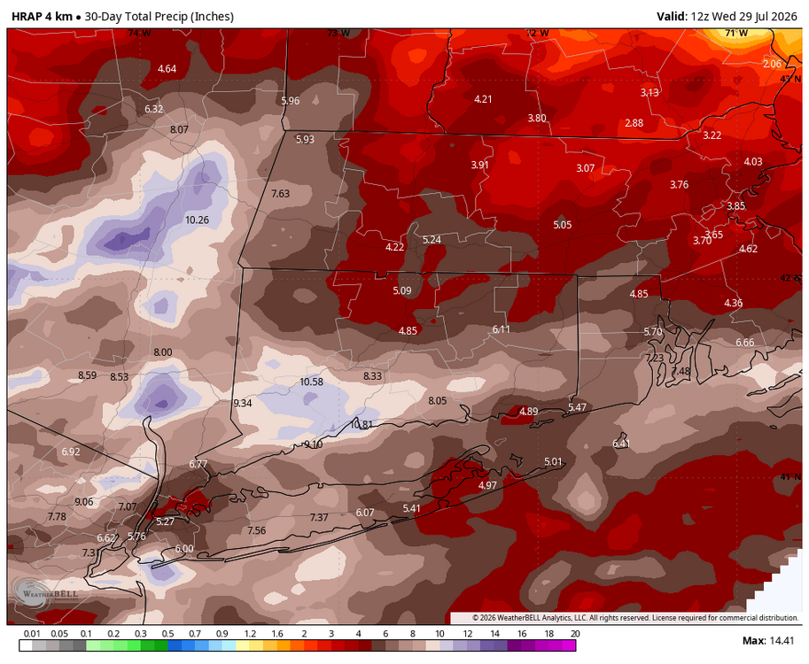
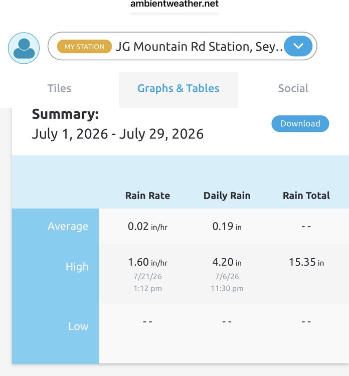
2.57" good drink.. 15.33" on the month..
-
 2
2
-
 1
1
-
 1
1
-
 1
1
-
-
HRRR did a very good job in this area, pretty much went exactly as I expected .
-
26 minutes ago, WinterWolf said:
Which one is right?
OXK radar is right, there has been no torrential rain with this, just good ole heavy rain.
-
27 minutes ago, CoastalWx said:
I will say the rain over Southwest CT is not Uber heavy at least.
No it's not its just heavy, nothing we can't handle 2-3" totals so far will probably max out at 3-4 iso 5" over a 4-6 hour window which isn't devastating, just some minor issues I'd imagine. Also looks like steady rain is done in SWCT within the hour.
-
2 minutes ago, CoastalWx said:
Maybe it’s closer to Western CT, but you gotta remember Low will develop later on tonight and at night as that happens the LLJ increases just saying to watch that area that’s all. Maybe it’ll be more progressive.
Ya that’s our opportunity to get bad , if that trains it will be trouble.
On a side note the local min golf spot in Oxford just reopened this month and they almost had another disaster last week with the 2” in 1 hour rainfall. They showed me pictures from the ‘24 flood and then last week when the river rose about 10’ in an hour and the mini golf is literally on the river about 15-20’ above it a dangerously close call.
-
9 minutes ago, Brian5671 said:
I think a bit further west towards the Hudson Valley....
Ya looks like swct will get mostly shut out today and tomorrow could be progressive. I wouldn’t mind missing the flash flooding
-
 1
1
-
-
7 minutes ago, Damage In Tolland said:
Wags west
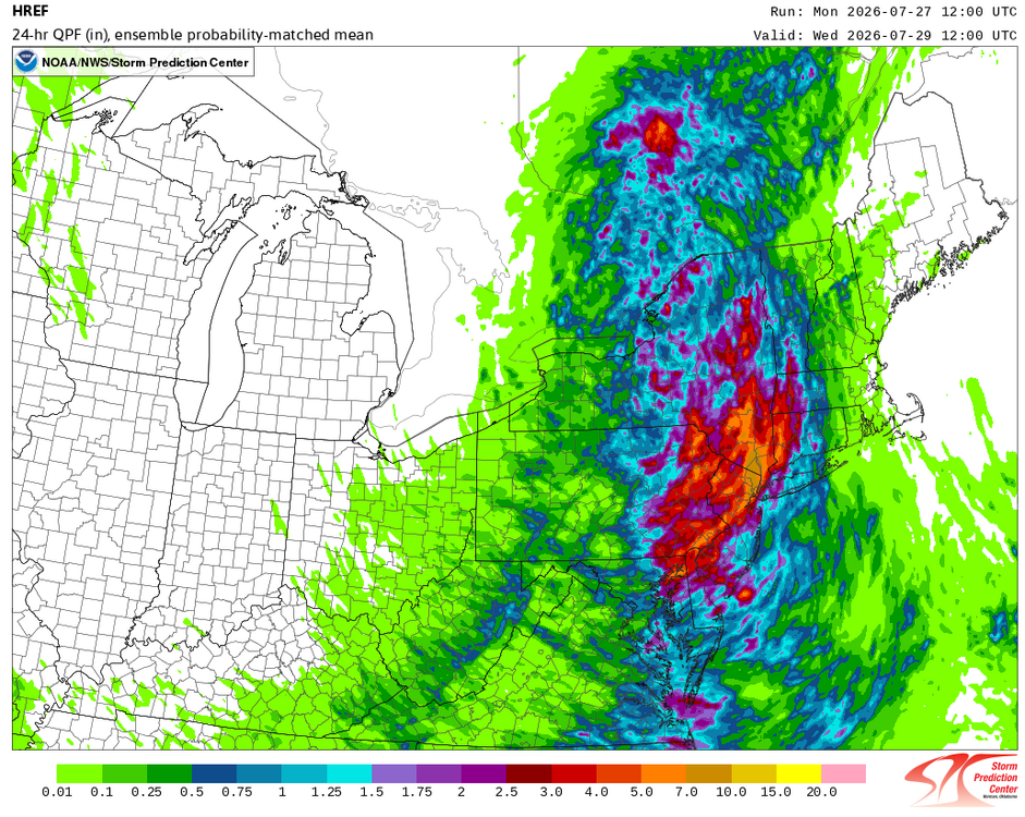
That only goes through 12z Wednesday
-
2
-
1
-
1
-
1
-
-
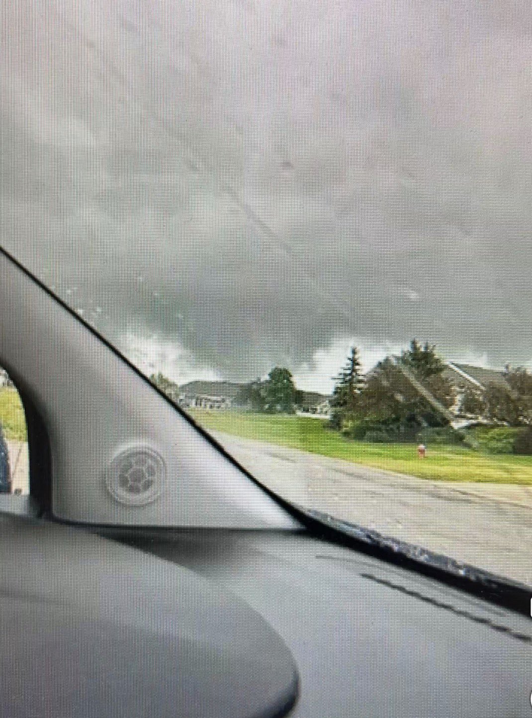
56 minutes ago, weatherwiz said:
Hoping there are no injuries or fatalities. That looks awful
EDIT: well no fatalities, I see injuries reported

Total destruction neighborhoods leveled horrible
-
 3
3
-
-
Just now, weatherwiz said:
ATW gusted to 45 knots. No report of funnel or TOR in the METAR but looks like it may have formed extremely close to the airport or passed by very close
https://x.com/intelpointalert/status/2081796276396363946?s=46
-
1
-
-
Just now, ineedsnow said:
Looks to have lifted now.. but appleton looks like it got nailed
Major damage search and rescue underway pics coming in now to X

-
1
-
2
-
-
4 minutes ago, Typhoon Tip said:
'normal' is a result of all events mixed together. Conceptually even a bone-heads ( well.. not Trump supporters) can see that the odds of any future event landing a result squarely on a number that is a mix of everything is remote, that means that actually hitting a normal value dead on is (philosophically) very low odds. This is particularly true for decimals (to the right) of the whole number
But it sounds like y'all could use a refresh, or perhaps a first time introduction to what is known in statistical science as 'Chi-Square test'. A formula that produces a rational value, then interpretive as a method for determining if the frequency differs from expected result.
It looks like this ...
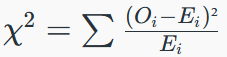
...that outta clear things up
Ya I was about to say the same exact thing,
-
1
-
-
9 minutes ago, WxWatcher007 said:
Yeah. A big day.


Weird I didn’t get as much rain as the operational product viewer and radar storm totals suggest. Still about 2-3” in an hour across the area, luckily just below flash flooding for most. A different story down near the Merritt by the looks of it on social media , 3-5” in about 90 min.
-
1
-
-
2 minutes ago, Brian5671 said:
Historic event unfolding here
HRRR fires storms around here through this evening no goodski for your area. We got 2” in like 30 min here but it already settled looks like double and still pouring south of here.
-
1 minute ago, dendrite said:
Hopefully you guys get a foot of rain
Halfway there in some spots
-
1
-
1
-
-
3-3.50” in last hour around Norwalk
-
2
-
-
4 minutes ago, CoastalWx said:
This will be bad for Merrit and 95
Ya doesn’t look good it’s slowing down
-
Just now, WxWatcher007 said:
Fortunately moving along…slowly…
Yes just hope it doesn’t back build or train, Trumbull area might get some training.
-
1 minute ago, WxWatcher007 said:
Ugly stuff in SW CT
Radar looks just like 2024
-
Scary look for Oxford and areas that got crushed two years ago, heaviest rain since then.
-
9 minutes ago, weatherwiz said:
It has a nice mid-level mesocyclone. If there was a bit more sf instability that would probably try producing. I wouldn't be shocked if some wind damage reports came in but perhaps its still a bit elevated so wind isn't mixing down. But there's also a big increase in lightning...a sign this is strengthening
Ya there’s some damage reports coming in now. Man it’s getting loud here already. Wild afternoon in store there will likely be some bad flash flooding in the area and potential for wind damage .
-
2
-
-
2 minutes ago, Brian5671 said:
Carnage incoming here if that holds together
Looks like we will See More Rain. Severe threat increasing locally too as heating builds ..
-
1
-
1
-


Ju-ply 2026 Obs and Disco - Kicking it off with heat, humidity, and ... severe?
in New England
Posted
Through 8am yesterday