

Sey-Mour Snow
-
Posts
5,272 -
Joined
-
Last visited
Content Type
Profiles
Blogs
Forums
American Weather
Media Demo
Store
Gallery
Posts posted by Sey-Mour Snow
-
-
2 minutes ago, The 4 Seasons said:
something wrong with you guys. Stop with the Nam.
Anyone in this thread right now has a problem , including you
-
 1
1
-
 3
3
-
-
Just now, CoastalWx said:
I’m broken.
Me too, why are we still looking at the NAM , looking for more heartbreak
-
 1
1
-
-
1 minute ago, CoastalWx said:
That was a solid advisory here. I won’t do it.
Do it
-
1
-
-
3 minutes ago, CoastalWx said:
Nam trying to suck Southcoastma in
And you .. lol
-
45 minutes ago, RUNNAWAYICEBERG said:
I’m a difficult grader.
This year gets a C- for snow because it doesn’t feel as bad with 7 of the last 8 years being below average. If this was pre 2018 it would get an F.
-
2 hours ago, RUNNAWAYICEBERG said:
We’ll have several more chances to be let down but I’m turning the mental exercising to baseball and lawncare.
Hopefully we get some 60s to melt the glacier and start lawncare, I usually start around March 15th..
-
1
-
-

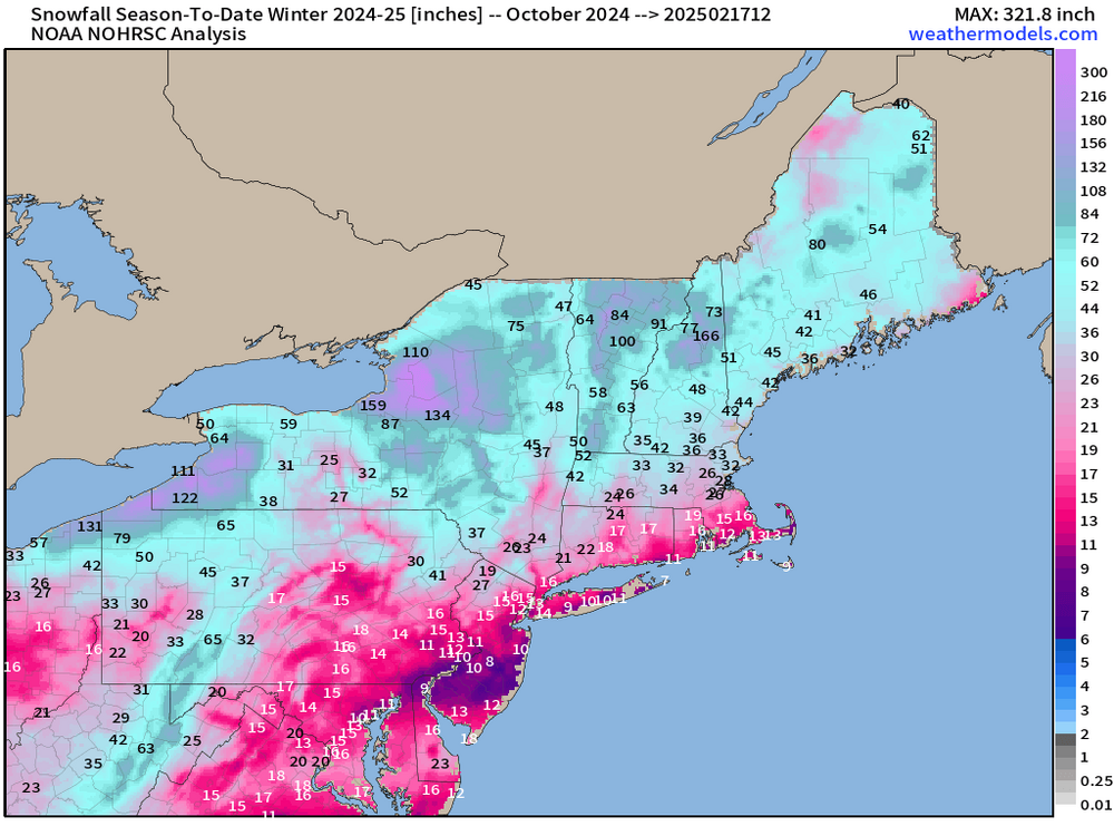
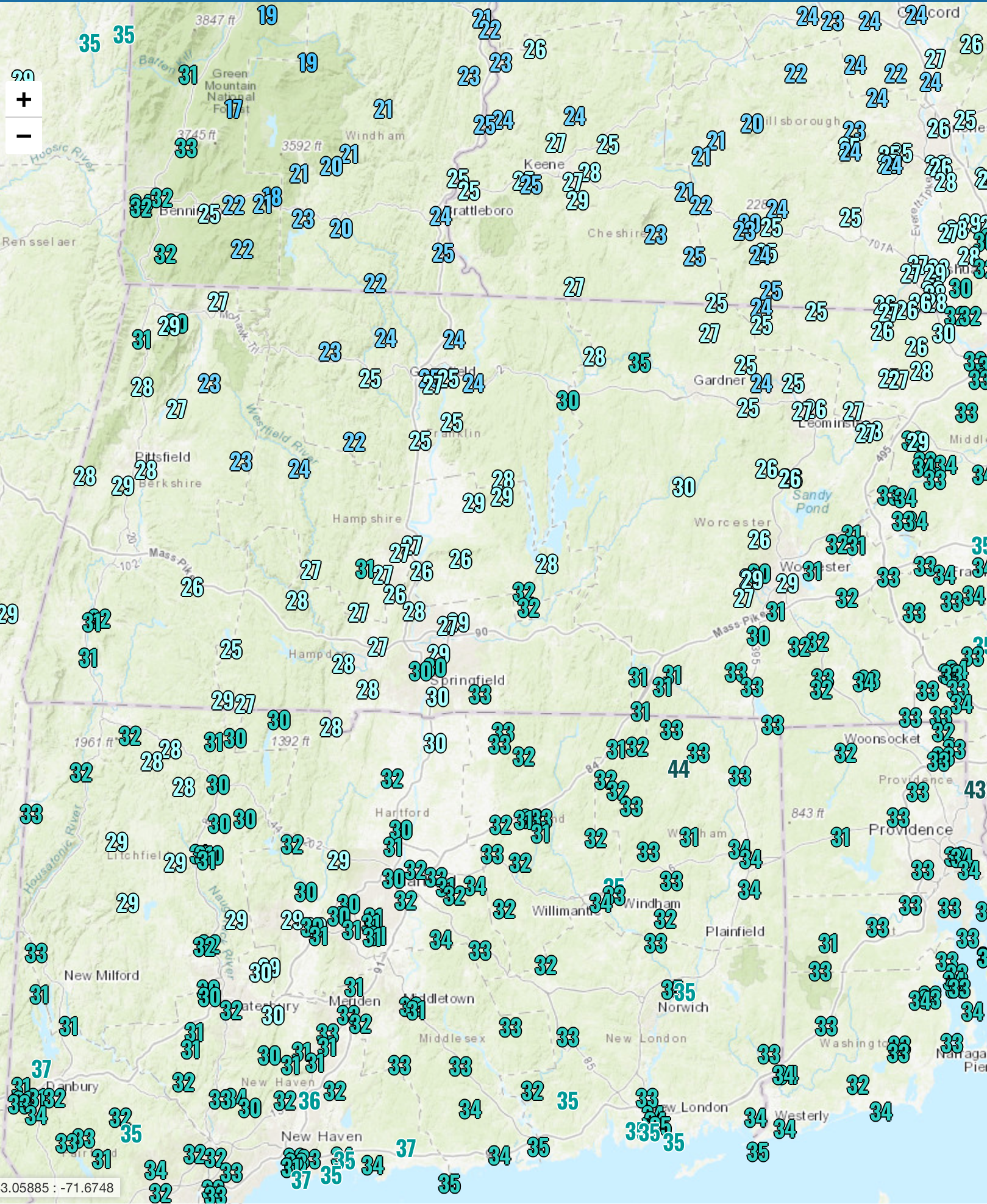
Great summary of our season.. next 10 days..
-
8
-
 1
1
-
3
-
-
Just now, BombsAway1288 said:
This hasn’t been a rough stretch at all. Sure, our fantasy big ones haven’t panned out but I’ve had more snowcover days on the coast this season than the last 3-4 years combined. Piles are huge right now, looks we’ve had a 12”+ storm. Pretty consistent cold too.
A rough stretch would be the last 2 winters. This one has not been that despite all the medium range fails.
Snow retention A+ this year , snowfall to date C-
-
3
-
-
5 minutes ago, Ginx snewx said:
RAT
-
 1
1
-
3
-
-
16 minutes ago, Hoth said:
The weenie melts in southern Delaware must be epic. From 20”+ to an inch in a few cycles.
DC had a 10" 24 hour snow mean at day 4.. 90+% 6" more with several eps members dropping 20"+ over them.. That's a bad fail at day 4 for EPS and EURO for the DC area.
-
7 minutes ago, The 4 Seasons said:
Good news, the 00Z UKMET goes over Bermuda
euro too lol
-
8 minutes ago, DavisStraight said:
Interesting, thought cold air dammed, was kind of a weird temp distribution today.
It was def odd, never seen it before. Litchfield county and the shore had the same temp
-
1 minute ago, DavisStraight said:
They're in a valley where cold air sinks and gets stuck, I'm a higher elevation in Worcester County so warmed too much to get ice.
The higher elevations in CT were colder, we got most of our icing when you were sleeting.
-
Temp spike comes post bow up 3 degrees in 15 min
-
Temp dropping maxed at 32.7 now 32 with freezing fog , bow echo of showers moving in looks like some wind with it
-
1
-
-
2 minutes ago, Damage In Tolland said:
is that timing of big winds/cold front?
Big winds move in after 7:30pm , cold after 8:30pm
-
2 minutes ago, Damage In Tolland said:
Tonight and tomorrow may play out like we’ve discussed .
Going to be wild here with all this ice on trees and the added wind after 7pm..
-
16 minutes ago, Spanks45 said:
Still sitting at 33.1⁰ I swear the trees continue to accumulate despite being above freezing. I was hoping the slushy/icy mess would melt off the walkway and driveway, but unless we get some real spike in temps soon, everything is going to freeze solid.
Hrrr colder every run now it’s max 33-36 around here still 32 here..
-
Still at freezing
-
1
-
1
-
-
3 minutes ago, H2Otown_WX said:
HRRR was too cold here. The 06z run had 31 at 17z and it's 34
Just right here.. euro is like 4 degrees too warm for 1pm here
-
Big slug of heavy rain moving in , here comes the poor drainage flooding..
-
Don’t know how it’s colder in southern ct than Mass. 32 here still accreting .35” radial.. still no power
-
11 minutes ago, dendrite said:
Those in the low 20s are likely still mostly/all sleet. Those climbing into the upper 20s have a little latent heat added at the surface. So a lot of times you can guesstimate the PL/ZR line where you see that low 20s/upper 20s gradient.

30 in the northern Litchfield hills and 33 at the Fairfield county coast don’t see that too often in this set up..
-
2 minutes ago, TalcottWx said:
Are we done or not? Ice.. Confused
Northern CT Will still have some ice accretion I’ll be above freezing by 11 or so


February 2025 Disco/Obs Thread
in New England
Posted
GFS cold and stormy from northern stream waves after this week.. 6z run was a weenie run for northern new england, just wave after wave up there..