Sey-Mour Snow
-
Posts
6,748 -
Joined
-
Last visited
Content Type
Profiles
Blogs
Forums
American Weather
Media Demo
Store
Gallery
Everything posted by Sey-Mour Snow
-

Feb 28th-March 1st long duration Miller B threat
Sey-Mour Snow replied to George001's topic in New England
I prefer to call it pound town . Hrrr looks sweet! -
Feb 28th-March 1st long duration Miller B threat
Sey-Mour Snow replied to George001's topic in New England
Cut back again. 4-6” for us -
Feb 28th-March 1st long duration Miller B threat
Sey-Mour Snow replied to George001's topic in New England
The public probably doesn't know what it means lol .. To me it could mean there is more potential to reach the higher end and beyond rather than the 4" Or 4-6" will be widespread with locally higher amounts, however you can just put that in font. -
Feb 28th-March 1st long duration Miller B threat
Sey-Mour Snow replied to George001's topic in New England
in line with my thoughts.. Such a sad graphic as in most of that snowstorm is in March and it's "Winter Storm Anthony" aka the first storm of the year.. -
Southern Illinois to central Ohio to south of Long Island. Only about 300 miles south of Chicago.
-
Feb 28th-March 1st long duration Miller B threat
Sey-Mour Snow replied to George001's topic in New England
Gfs pretty much exact same output as 12z.. great for all of ct.. guidance honing in an a max near Granby up onto mass of 8-12”… -
Feb 28th-March 1st long duration Miller B threat
Sey-Mour Snow replied to George001's topic in New England
From upton disco… Forecast snowfall totals have been largely unchanged for NYC and Long Island and nudged up slightly across the Lower Hudson Valley, Southern CT and interior northeast NJ due to the increasing confidence given the aforementioned trend in the secondary low. Widespread Advisory level snow looks likely across the Lower Hudson Valley, Southern CT and interior northeast NJ with 3-5 inches. Would not be surprised to see this upward trend continue. yet they took numbers down from the 4-6” they had overnight? Makes zero sense -
Feb 28th-March 1st long duration Miller B threat
Sey-Mour Snow replied to George001's topic in New England
Ya no doubt after 12z we will struggle to add anything .. lol upton advisory for only 3-5” here .. we usually get the upton reverse jinx so we should be good for 6-10” based on their forecast -
Feb 28th-March 1st long duration Miller B threat
Sey-Mour Snow replied to George001's topic in New England
I think once the sun comes up we can forget about accumulations with borderline temps for many. However, Many areas out in CT should exceed 10:1 ratios during the peak with heavy snow falling between 10pm and 6am so no effects of the March sun to worry about. Also most guidance has temps between 23-28 for the duration of the heavy precip just inland. The driest guidance has about ..4-.5” qpf with the wettest about .8-1.0” qpf. With a bit of ratios between 10-15:1 during the thump I think it’s a fairly easy widespread 6”+ for much of CT. Also looks like great lift in the snow growth zone on hi res data. Just my two cents. -
Feb 28th-March 1st long duration Miller B threat
Sey-Mour Snow replied to George001's topic in New England
Definitely still a good thump for SW 2/3 but about 15% cut back from 00z.. still a solid 4-6”+ away from the NE corner . -
Feb 28th-March 1st long duration Miller B threat
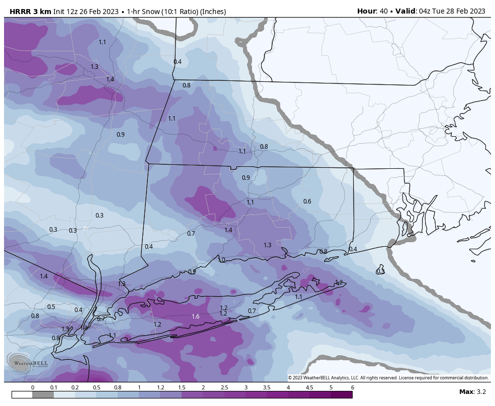
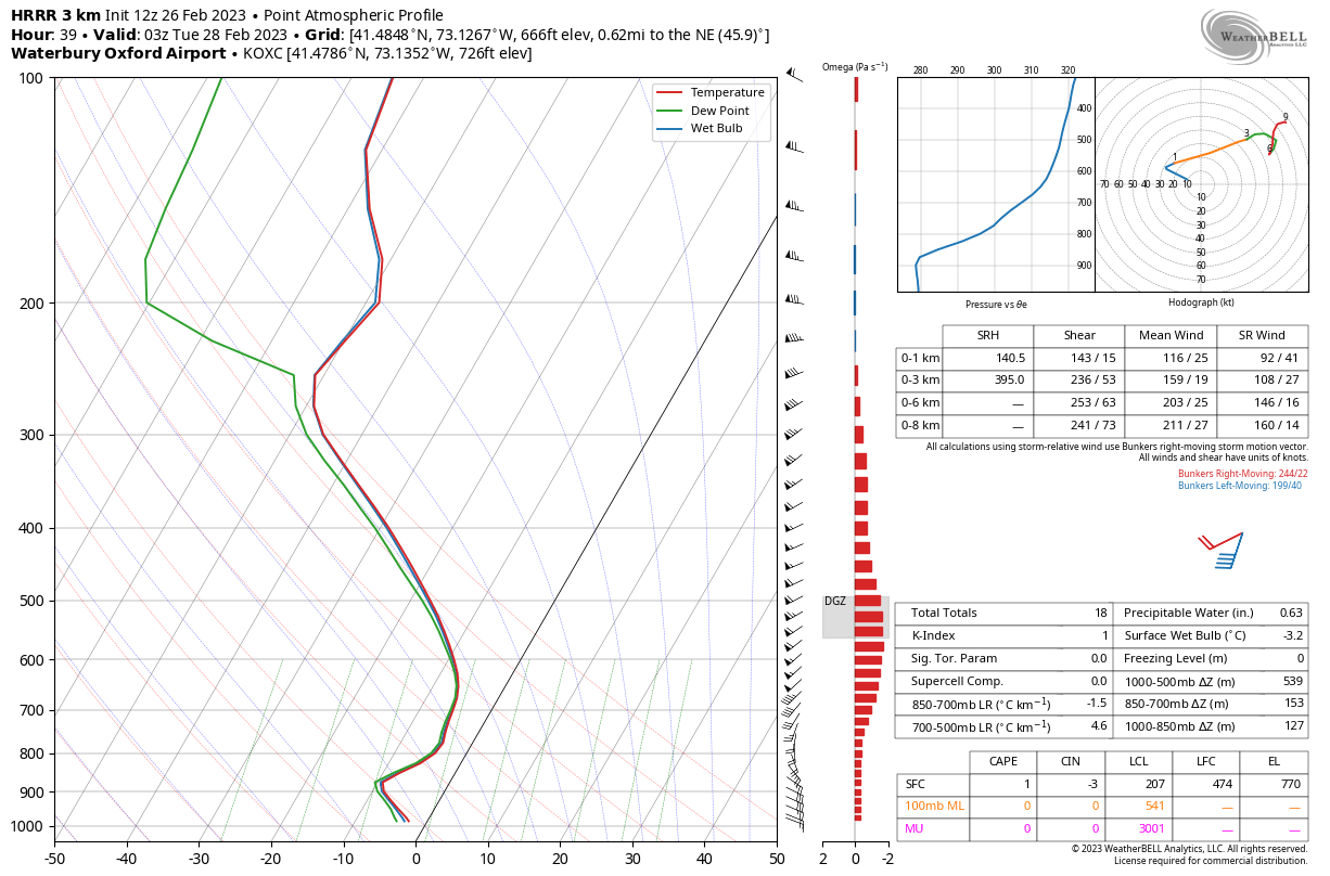
Sey-Mour Snow replied to George001's topic in New England
HRRR, 3km nam, and href look very thumpy with impressive rates between 9pm and 3am
.thumb.jpg.b84a13de4bd19c87257dc32d985b57a8.jpg)

-
New England Met Winter 2022-2023 Banter
Sey-Mour Snow replied to HoarfrostHubb's topic in New England
Forum is on a budget? purchased it from $1 emoji dot com ? -
Feb 28th-March 1st long duration Miller B threat
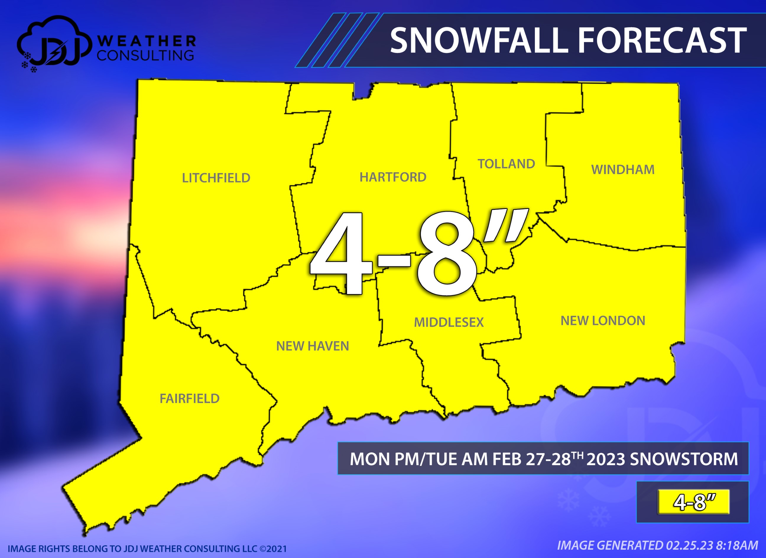
Sey-Mour Snow replied to George001's topic in New England
We put this out this morning.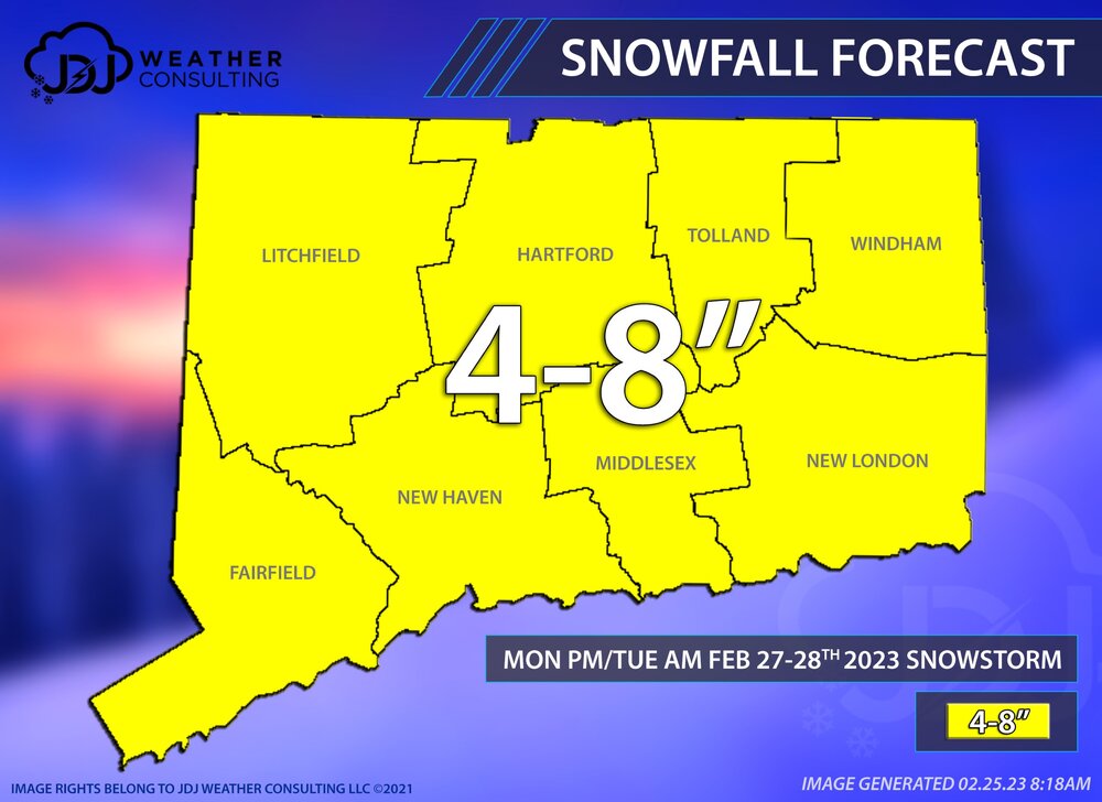
-
Feb 28th-March 1st long duration Miller B threat
Sey-Mour Snow replied to George001's topic in New England
Ya it was somehow worse out east while being a bit better out west. I hope everyone can cash in for a uniform 4-8” across SNE when all is said and done. -
New England Met Winter 2022-2023 Banter
Sey-Mour Snow replied to HoarfrostHubb's topic in New England
-
Feb 28th-March 1st long duration Miller B threat
Sey-Mour Snow replied to George001's topic in New England
I don’t think anyone in southern CT has a problem with the EURO solution verbatim. -
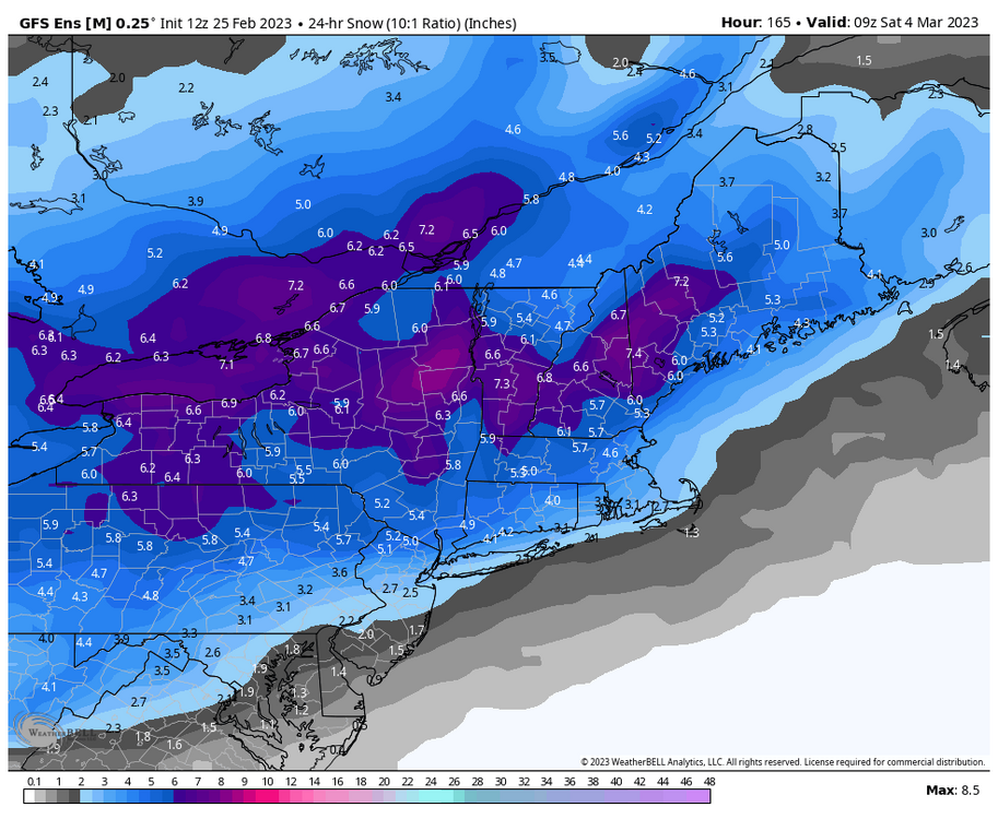
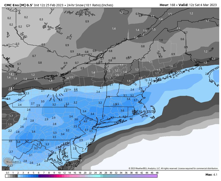
Timing differences bc of map availability but we get an idea where the axis is.
-
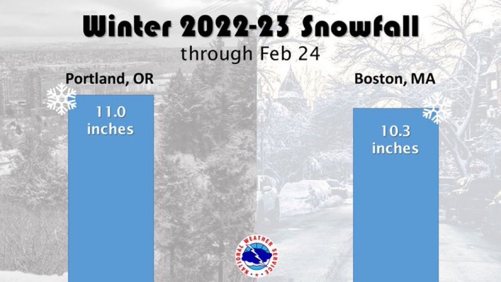
Ya the .3” was great 1.2”’ now in the last 11 weeks. We should double to triple our season total Monday night hopefully
-
-
Feb 28th-March 1st long duration Miller B threat
Sey-Mour Snow replied to George001's topic in New England
No doubt we have gotten some great events in the 8-16” range and over performed in many. Just missing the big ones that you guys have gotten out east. But no lack of the widespread 8-16” events we’ve had one every single year. -
Feb 28th-March 1st long duration Miller B threat
Sey-Mour Snow replied to George001's topic in New England
You were threatening to steal his snow lol -
Feb 28th-March 1st long duration Miller B threat
Sey-Mour Snow replied to George001's topic in New England
Patience grasshopper , there’s still a way to several inches for us.. it’s just the gfs , I’d rather have euro on our side now. -
Feb 28th-March 1st long duration Miller B threat
Sey-Mour Snow replied to George001's topic in New England
If that stayed all snow it’s a hell of a thump though .. -
Feb 28th-March 1st long duration Miller B threat
Sey-Mour Snow replied to George001's topic in New England
Least snowy for all of southern ct and it’s not even close. -
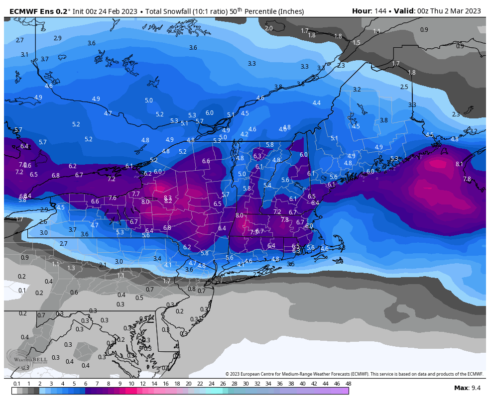
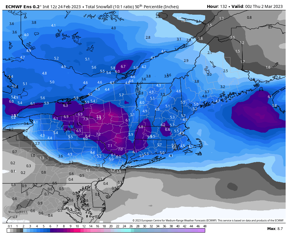
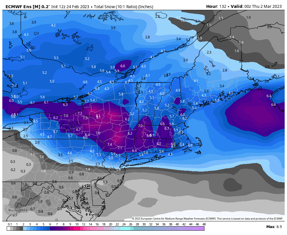
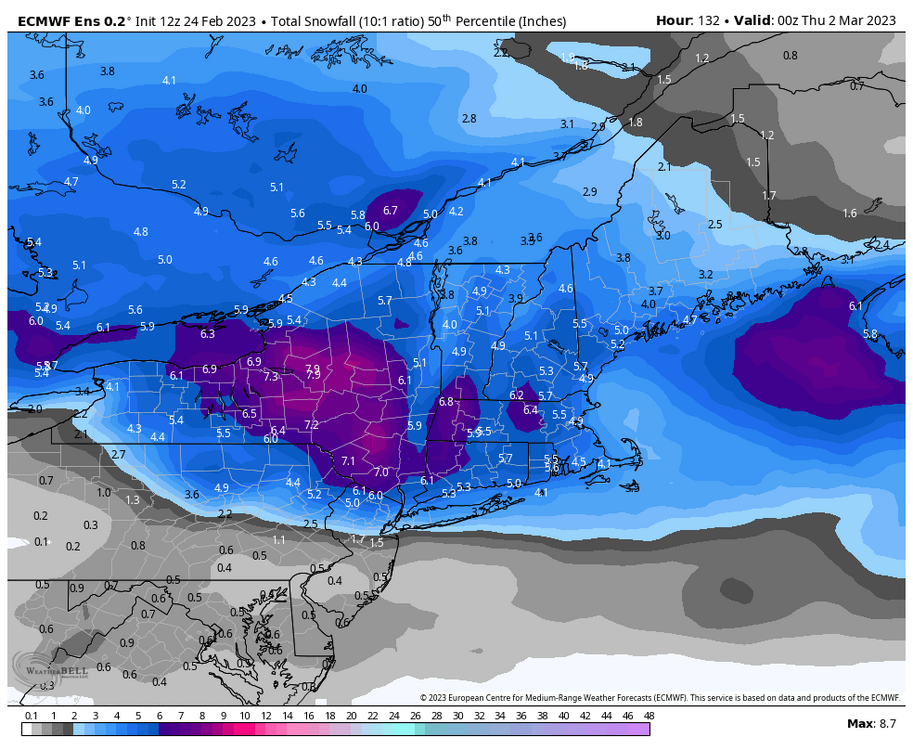
Feb 28th-March 1st long duration Miller B threat
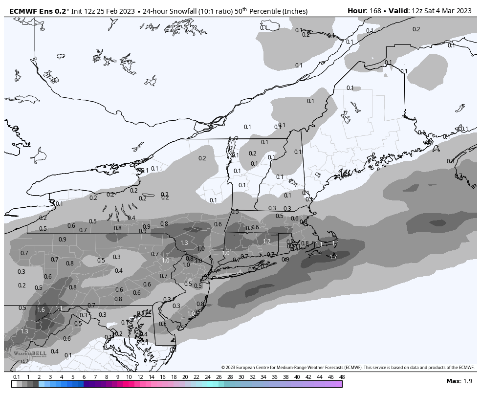
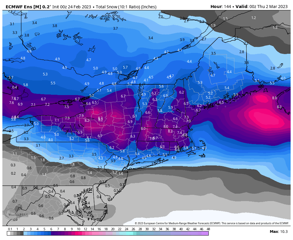
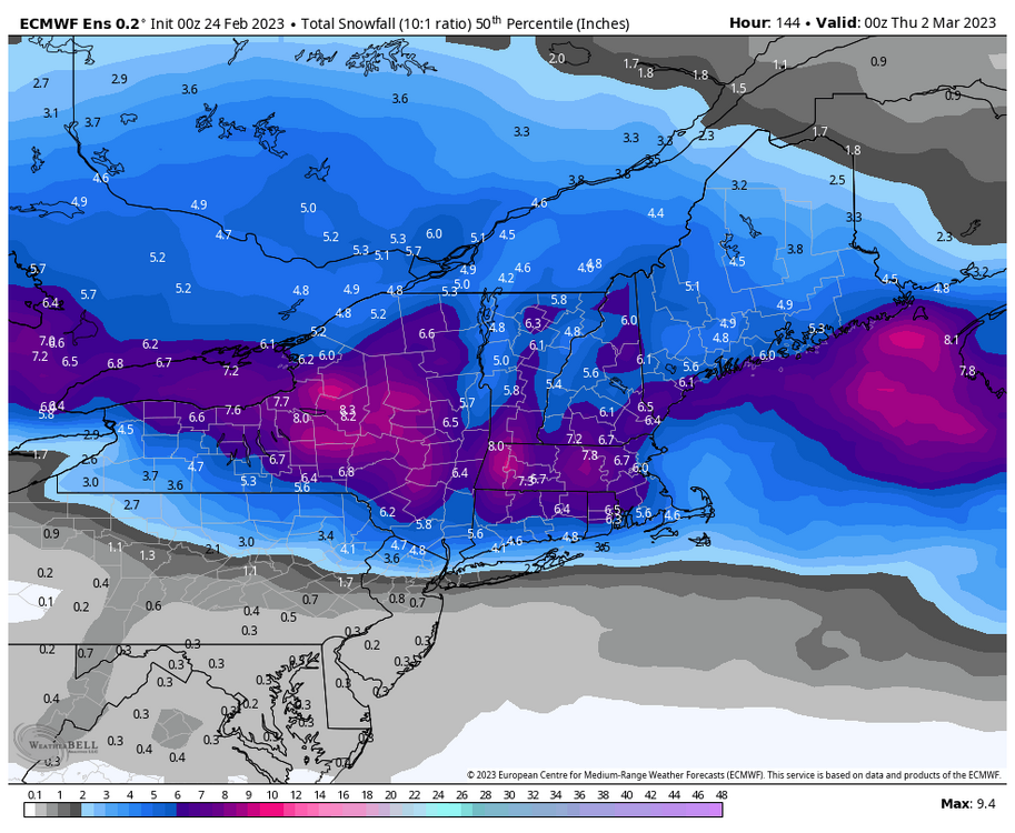
Sey-Mour Snow replied to George001's topic in New England
Here’s the 12z eps mean and 50th percentile compared to 00z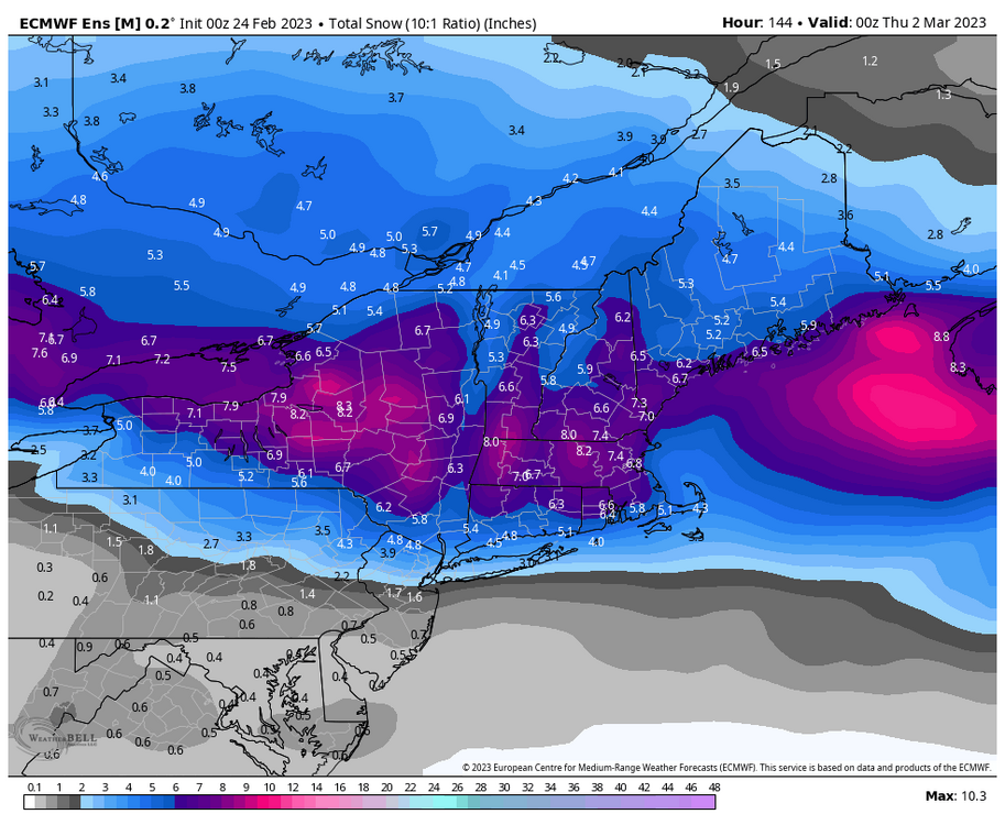


.jpg.26f7fdb41583cdcea5604bb1a19f27af.jpg)