Sey-Mour Snow
-
Posts
6,825 -
Joined
-
Last visited
Content Type
Profiles
Blogs
Forums
American Weather
Media Demo
Store
Gallery
Everything posted by Sey-Mour Snow
-
 700mb track is awful for southern CT and all of south coast, be wary of those snow maps.. Great run 84 north ..
 -
ya exactly CT and pike south is favored on EPS for a plowable snow.. some are just a bit wary of those 10% way NW members ...
-
Ya the bullseye is def over us on the MEAN most members jack this area.. The confusing part is the amped NW members are pike north hits which throws off the other maps.. CT is the favored location on the EPS as most of the members have 6"+ there.. The 12" + super amped members (10% of the members) are pike north..
-
To be fair to @Damage In Tolland euro does have this starting 7-10pm Monday for CT , GFS is 3-6am Tuesday.. It's about a 6 hour thump verbatim with some light snow on either side of the thump ..
-
As the kids say . You are doing too much bro
-
How about March 2019?
-
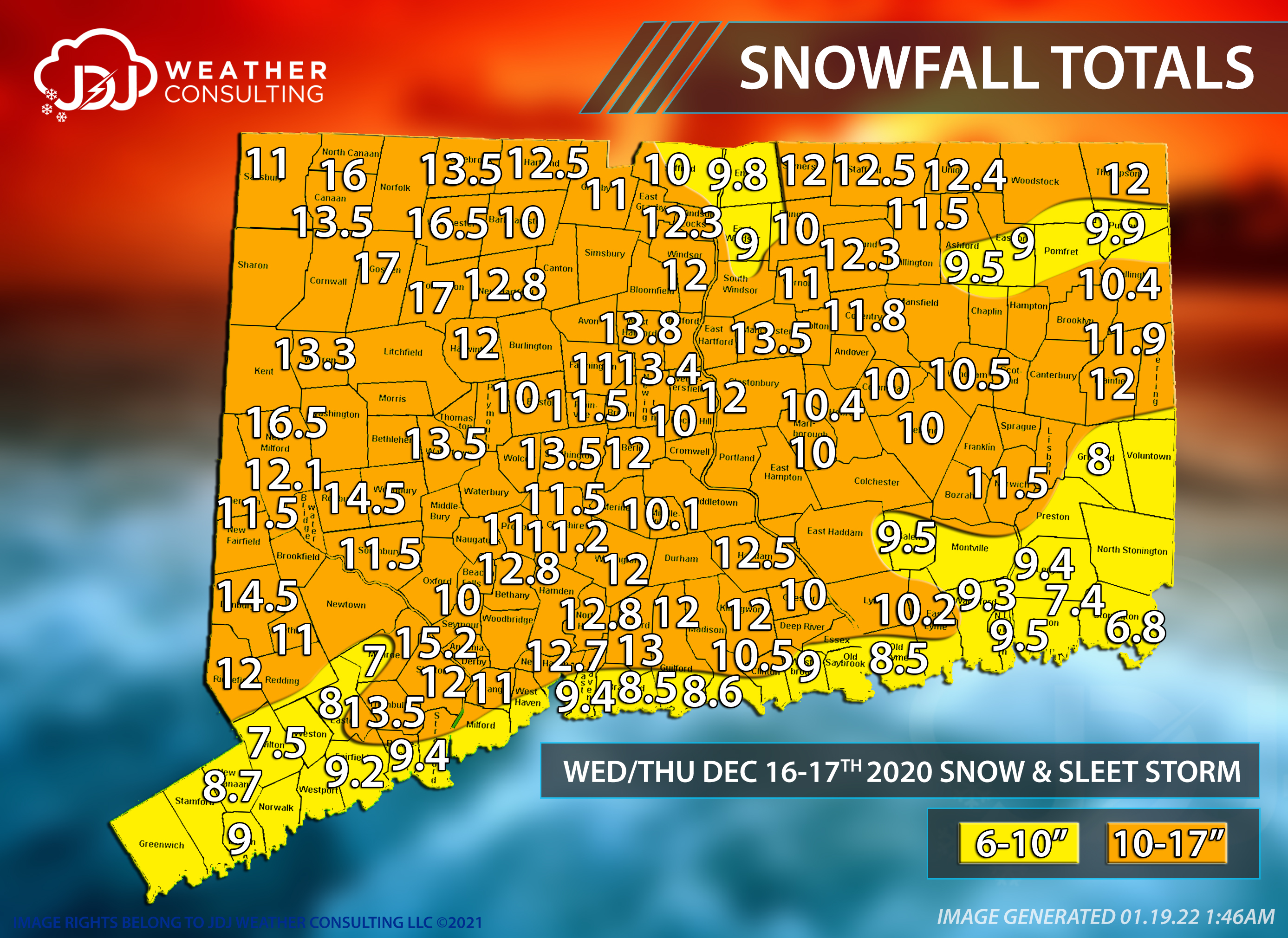
Hopeful as of now. Just looking at some stats with the guys we are at just 3 storms over 10” in the last 6 winters for this area.
-
Me and Runnaway had 8-10” then sleet raced north to the pike your area and Wolfie and a local max maybe ?. Most in CT had about 8-12” from that one with the jack in Hartford/litchfield county line of 17”.

-
Ya looks like mostly 8-12” highest north west of 17” iso in Litchfield/ Hartford county line.
-
Yes Christmas eve night
-
Last second had some big jumps north we were thinking 12-18”+ but verified 10” most of southern CT.
-
6z GEFS has so much spread the 50th percentile is virtually nothing for everyone.. Even amount of rainers, and good hits, but more whiffs.. actually like where we are now with gfs being south and euro being north..
-
At least it trended better for Saturday . Low 60s hopefully
-
What’s funny is the infamous weenie high after being “Nam’d” for lack of better words is not attainable nowadays in the 4-5 day range (which wasn’t always the case). If that EURO run just dropped a 48” snow bomb across all of New England at day 5 it would do nothing for us bc we know it has almost no chance of verifying.
-
I agree ensemble storm tracks have been extremely volatile this year. Need to wait this one out until we get multiple cycles of consistency
-
It’s ok never phases in time just a pedestrian snow fall for CNE/NNE
-
Faster and less interaction no run to run continuity yet. Much worse for most . We will get something vastly different at 00z I assume
-
Ya I bet the fact that it comes out first is a big reason why its even looked at and talked about .. If it came out at the same time as GFS and Canadian I bet it would be forgotten.. Having it come out during the dead time can satisfy a weenies craving to get NAM'd or in this case i- CON'd pun intended
-
It was a Flop... February 2024 Disco. Thread
Sey-Mour Snow replied to Prismshine Productions's topic in New England
Same.. would feel great RT 2 north.. Still can go south as Will said, glancing over things slower seems it would favor south.. some of the bombs on EPS are faster and farther north.. Would be nice to get a regionwide event from Greenwich CT to Maine .. But that's asking a lot I know -
Damn! Some crazy amped members that would likely still be bombing out if this went out post 144
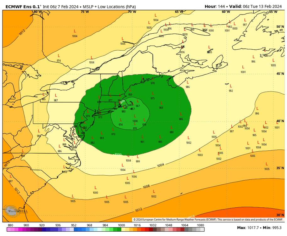
-
LOL I can proudly say I've never had to refresh my webpage waiting for the ICON model to load. Although I hear it's slightly better this winter.. @ORH_wxman what are your thoughts on the ICON's performance recently?
-
It was a Flop... February 2024 Disco. Thread
Sey-Mour Snow replied to Prismshine Productions's topic in New England
Keep in mind that’s only half the storm bc 6z only goes out to 144 -
It was a Flop... February 2024 Disco. Thread
Sey-Mour Snow replied to Prismshine Productions's topic in New England
I've been on the time period since day 16.5.. but seriously that timeframe makes sense but I don't care what any op says until later next week.. Need a well timed PNA spike and the NAO to start decaying not overwhelming .. That time period may be SNE's best shot if the 12-13th does what I think it will -
It was a Flop... February 2024 Disco. Thread
Sey-Mour Snow replied to Prismshine Productions's topic in New England
Ensembles really like CNE and NNE on the 12-13th.. -
It was a Flop... February 2024 Disco. Thread
Sey-Mour Snow replied to Prismshine Productions's topic in New England
Legit chance you get 10 weenies on that one .. It's day 12.. Need a legit PNA spike to bring something north as we've been saying for that timeframe..