

wxsniss
-
Posts
5,812 -
Joined
-
Last visited
Content Type
Profiles
Blogs
Forums
American Weather
Media Demo
Store
Gallery
Everything posted by wxsniss
-
Watching closely .. February 1-3rd for moderate to major coastal event
wxsniss replied to Typhoon Tip's topic in New England
Spawns a new low, but it's too far offshore... impacts northeastern ME -
Watching closely .. February 1-3rd for moderate to major coastal event
wxsniss replied to Typhoon Tip's topic in New England
All this energy spawning disparate lows reminds me of a storm a few years ago... sorry I can't remember the date... On guidance a large trough with multiple pieces of vorticity spawning different SLPs as they hit the coast, and we compared it to mogwais... guidance struggled and eventually coalesced into a single dominant SLP... reality was a SNE blizzard RGEM did the same thing as CMC and HRPDS, and Euro hints at it too... glad to see a potential popping up before it's off Maine -
Watching closely .. February 1-3rd for moderate to major coastal event
wxsniss replied to Typhoon Tip's topic in New England
0z RGEM really goes to town with that leftover vorticity Wed Euro hints at it too -
Watching closely .. February 1-3rd for moderate to major coastal event
wxsniss replied to Typhoon Tip's topic in New England
But still delivers to eastern SNE... in fact a tick colder in interior southeast MA -
Watching closely .. February 1-3rd for moderate to major coastal event
wxsniss replied to Typhoon Tip's topic in New England
0z NAM... not what I wanted to see. Sizeable jump southwest thru 21 hrs. Will have the Philly forum cheering. -
Watching closely .. February 1-3rd for moderate to major coastal event
wxsniss replied to Typhoon Tip's topic in New England
Exactly what I was thinking 8-12" city proper, 10-14" you / metrowest If 0z NAM holds, I think that's a great forecast. I'm tossing RGEM/old-GFS/UK. -
Watching closely .. February 1-3rd for moderate to major coastal event
wxsniss replied to Typhoon Tip's topic in New England
Agree, Dec event was much better organized... this one is more disjointed, with mid and upper level centers maybe further southwest than ideal, but apparently plenty of WAA lift + 850 fetch to deliver. What are you thinking for Chestnut Hill? The other puzzle is what happens Tuesday. Guidance all over the place with that. -
Watching closely .. February 1-3rd for moderate to major coastal event
wxsniss replied to Typhoon Tip's topic in New England
...and other times deliver over-performers like Dec 17. Box seems to have favored the NAM/HREF dynamics for Monday afternoon. I think 8-12" Boston city proper, 10-14" suburbs / metro west is very realistic. Verbatim off NAM, this will be a wild afternoon commute... would be 1-2" / rates for hours: -
Watching closely .. February 1-3rd for moderate to major coastal event
wxsniss replied to Typhoon Tip's topic in New England
Yeah there's a ridiculous spread in guidance for Tuesday... Just compare RGEM vs. NAM for 18z Tues -
Watching closely .. February 1-3rd for moderate to major coastal event
wxsniss replied to Typhoon Tip's topic in New England
Yep tick east, cooler but less prolific with qpf --- really key point is it did not make a last minute jump towards RGEM/old-GFS: -
Watching closely .. February 1-3rd for moderate to major coastal event
wxsniss replied to Typhoon Tip's topic in New England
Box AFD: Heavy snow... As mentioned above very cold/dry airmass over the region this evening will set the stage for an impressive front end thump of heavy snow Monday afternoon and evening. Very strong easterly jet at 850 mb of 5 standard deviations will provide an Atlantic fire hose of moisture to overrun the cold/dry airmass currently over the region. This strong forcing for ascent will be enhanced by mid level instability Monday afternoon and evening as dry slot approaches. This entrainment of mid level dry air will steepen mid level lapse rates and result in 1-2" hourly snowfall rates Mon afternoon and evening. HREF supports this with high probs of 1-2" hourly rates. Even the HREF hourly mean is 1.5-2.0 inches. That combined with instability aloft, would not be surprised if 3+ inch hourly rates for a time in the strongest snow bands, along with a low risk of TSSN! Nevertheless, travel will be extremely difficult Monday afternoon and evening given these hourly snowfall rates. Given the evaporative cooling potential initially, followed the colder guidance here. Although given low level temps are marginal across Eastern CT/RI/MA, followed the lower SLR from the NBM which are less than 10-1. Although this may be offset early on as snow growth is very favorable 18z-00z. Thus heavy wet snow across this region will increase the risk for snow loading issues/tree damage and power outages. -
Watching closely .. February 1-3rd for moderate to major coastal event
wxsniss replied to Typhoon Tip's topic in New England
18z NAM 10:1, through 48 hrs, 18z Tues... best one yet for much of SNE: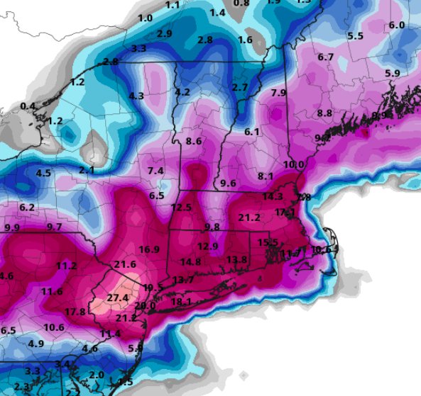
-
Watching closely .. February 1-3rd for moderate to major coastal event
wxsniss replied to Typhoon Tip's topic in New England
Best run yet for just about all of SNE One of the most steady NAM performances I can remember... other guidance has wavered alot more As noted earlier, this is almost dead on with the HREF -
Watching closely .. February 1-3rd for moderate to major coastal event
wxsniss replied to Typhoon Tip's topic in New England
NAM has been incredibly steady since Saturday crushing for much of SNE at hr 30, including eastern MA -
Watching closely .. February 1-3rd for moderate to major coastal event
wxsniss replied to Typhoon Tip's topic in New England
18z NAM holding strong, if not a tick east thru Crushing firehouse for southern SNE, CT into NYC area at hr 27 -
Watching closely .. February 1-3rd for moderate to major coastal event
wxsniss replied to Typhoon Tip's topic in New England
Compared to 0z run, definitely ticked colder in eastern SNE at 850 and 925... but the WAA thump was not as robust as 0z, and mechanics are still a little disjointed... so not as robust a solution as NAM -
Watching closely .. February 1-3rd for moderate to major coastal event
wxsniss replied to Typhoon Tip's topic in New England
Thru hr 30, H7 low definitely ticked northeast -
Watching closely .. February 1-3rd for moderate to major coastal event
wxsniss replied to Typhoon Tip's topic in New England
Yeah I wouldn't take verbatim just yet, but it is very consistent with NAM which has been surprisingly steady for 6+ cycles now, and other guidance has ticked colder for eastern SNE... -
Watching closely .. February 1-3rd for moderate to major coastal event
wxsniss replied to Typhoon Tip's topic in New England
Between work, baby, GME, haven’t posted as much as I’d like... This is looking great for SNE: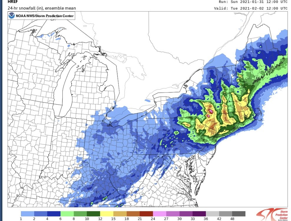
-
Watching closely .. February 1-3rd for moderate to major coastal event
wxsniss replied to Typhoon Tip's topic in New England
HREF supports NAM and HRRR: Thru Tues 0z only: -
Watching closely .. February 1-3rd for moderate to major coastal event
wxsniss replied to Typhoon Tip's topic in New England
From 12z Initial thump will deliver -
Watching closely .. February 1-3rd for moderate to major coastal event
wxsniss replied to Typhoon Tip's topic in New England
NAM is like [emoji184]🤲[emoji184]🤲[emoji184] Surprisingly may be the most steady guidance since Saturday Add CF enhancement to this: -
Watching closely .. February 1-3rd for moderate to major coastal event
wxsniss replied to Typhoon Tip's topic in New England
0z NAM 10:1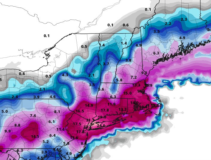
-
Watching closely .. February 1-3rd for moderate to major coastal event
wxsniss replied to Typhoon Tip's topic in New England
Hour 54... 6z 2/2... huge hit on eastern SNE... actually a tick colder than 18z Is it fair to say that strangely enough, NAM has been one of the more consistent models today? -
From Washington Post / Boston.com today... Not agreeing or disagreeing, and I know previously discussed here extensively... Simplistic explanation of recent SSW event, split PV, negative AO / NAO, possible implications for us: https://www.boston.com/uncategorized/weather/2021/01/05/the-polar-vortex-is-splitting-in-two-which-may-lead-to-weeks-of-wild-winter-weather

