wxsniss
-
Posts
5,812 -
Joined
-
Last visited
Content Type
Profiles
Blogs
Forums
American Weather
Media Demo
Store
Gallery
Everything posted by wxsniss
-
Dec 5/6th major coastal/ west Atlantic cyclogenesis ...?
wxsniss replied to Typhoon Tip's topic in New England
Oh absolutely, if we're talking a stretch of weather... Feb 15 no comparison, probably not again in our lifetime. But for a single storm... Feb 15 blizzard is up there, but still did not match the sheer extreme conditions I witnessed Apr 97 and Jan 05 -
Dec 5/6th major coastal/ west Atlantic cyclogenesis ...?
wxsniss replied to Typhoon Tip's topic in New England
Yeah there are several in contention for #3 including Feb 14-15 2015, Mar 13 2018 But I have footage from Jan 05 that I have never witnessed since... near hurricane force winds hard to stay upright + whiteout in Fenway and Harvard Square, single digit temps... it was unreal. I only wish I had footage from April 97... the awe of an earlier changeover in the afternoon, hours of thundersnow at night. -
Dec 5/6th major coastal/ west Atlantic cyclogenesis ...?
wxsniss replied to Typhoon Tip's topic in New England
That is the funniest thing I've seen in a while here... might even make non-weatherbuffs laugh -
Dec 5/6th major coastal/ west Atlantic cyclogenesis ...?
wxsniss replied to Typhoon Tip's topic in New England
April 97 Jan 05 -
Dec 5/6th major coastal/ west Atlantic cyclogenesis ...?
wxsniss replied to Typhoon Tip's topic in New England
...and downstream track ticked southeast. Not sure if any merit until more supporting evidence. EDIT: scratch that, nearly identical location by 21z Sat -
Dec 5/6th major coastal/ west Atlantic cyclogenesis ...?
wxsniss replied to Typhoon Tip's topic in New England
4z RAP vs. 0z NAM continues with less stream interaction comparing at Sat 6z timepoint -
Dec 5/6th major coastal/ west Atlantic cyclogenesis ...?
wxsniss replied to Typhoon Tip's topic in New England
3z HRRR SLP track looks a good bit south of 0z NAM track, probably part of why the changeover happens hours earlier in Boston metro -
Dec 5/6th major coastal/ west Atlantic cyclogenesis ...?
wxsniss replied to Typhoon Tip's topic in New England
Fwiw: 3z RAP vs. 0z NAM for Sat 3z-6z Timepoints: RAP has less H5 N/S stream interaction than NAM -
Dec 5/6th major coastal/ west Atlantic cyclogenesis ...?
wxsniss replied to Typhoon Tip's topic in New England
That's a very good map regionwide, and agree with 1-3/3-6 straddling Boston metro -
Dec 5/6th major coastal/ west Atlantic cyclogenesis ...?
wxsniss replied to Typhoon Tip's topic in New England
It's pretty close overall... within range of noise Might also be a tic slower -
Dec 5/6th major coastal/ west Atlantic cyclogenesis ...?
wxsniss replied to Typhoon Tip's topic in New England
0z NAM thru 21 hours... colder profiles for eastern SNE interests, definite tic east -
Dec 5/6th major coastal/ west Atlantic cyclogenesis ...?
wxsniss replied to Typhoon Tip's topic in New England
I saw it on boston.com lol... originally posted on their twitter. Yeah I think I've seen it 1 or 2 times before, so I don't think it's generated for most storms. And obviously not written in stone. Will be a fun afternoon nowcasting! -
Dec 5/6th major coastal/ west Atlantic cyclogenesis ...?
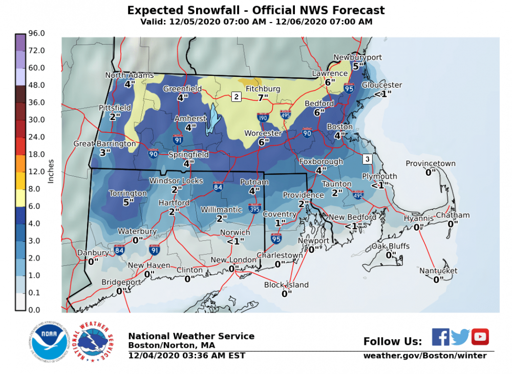
wxsniss replied to Typhoon Tip's topic in New England
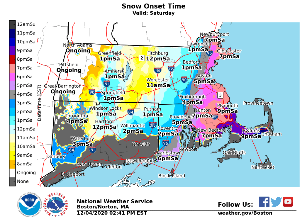
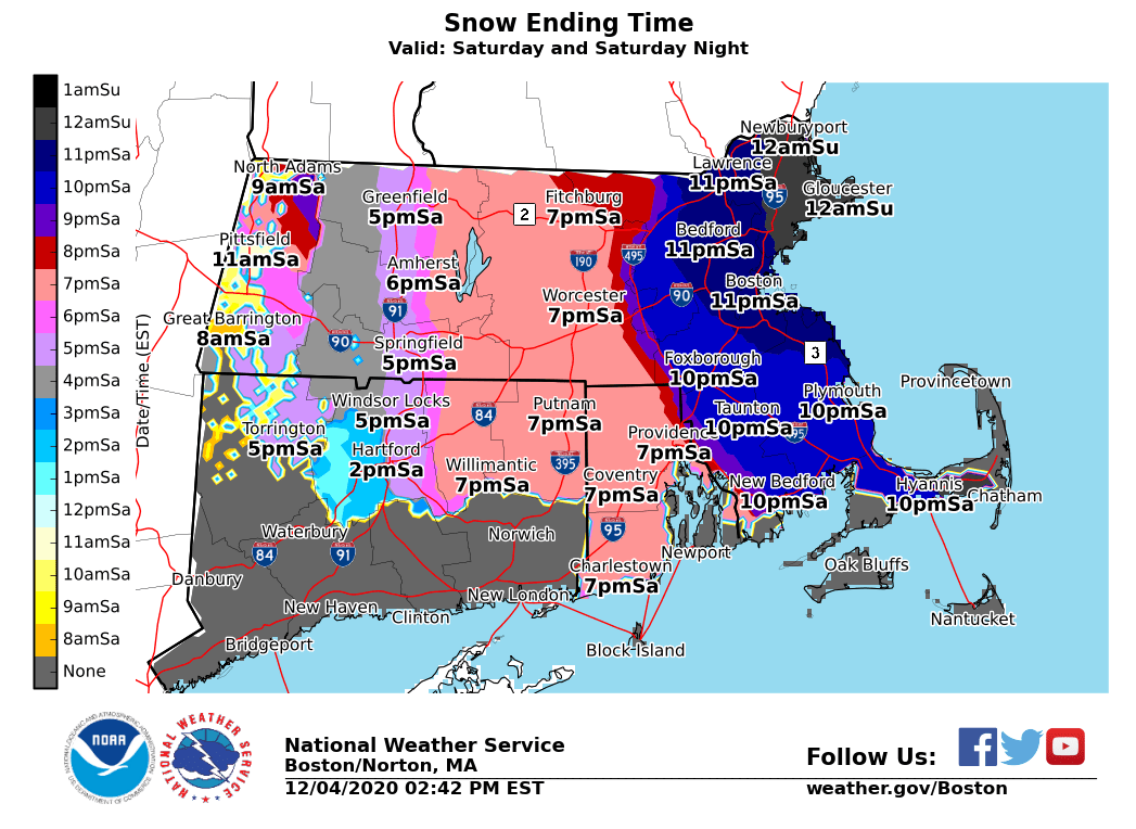
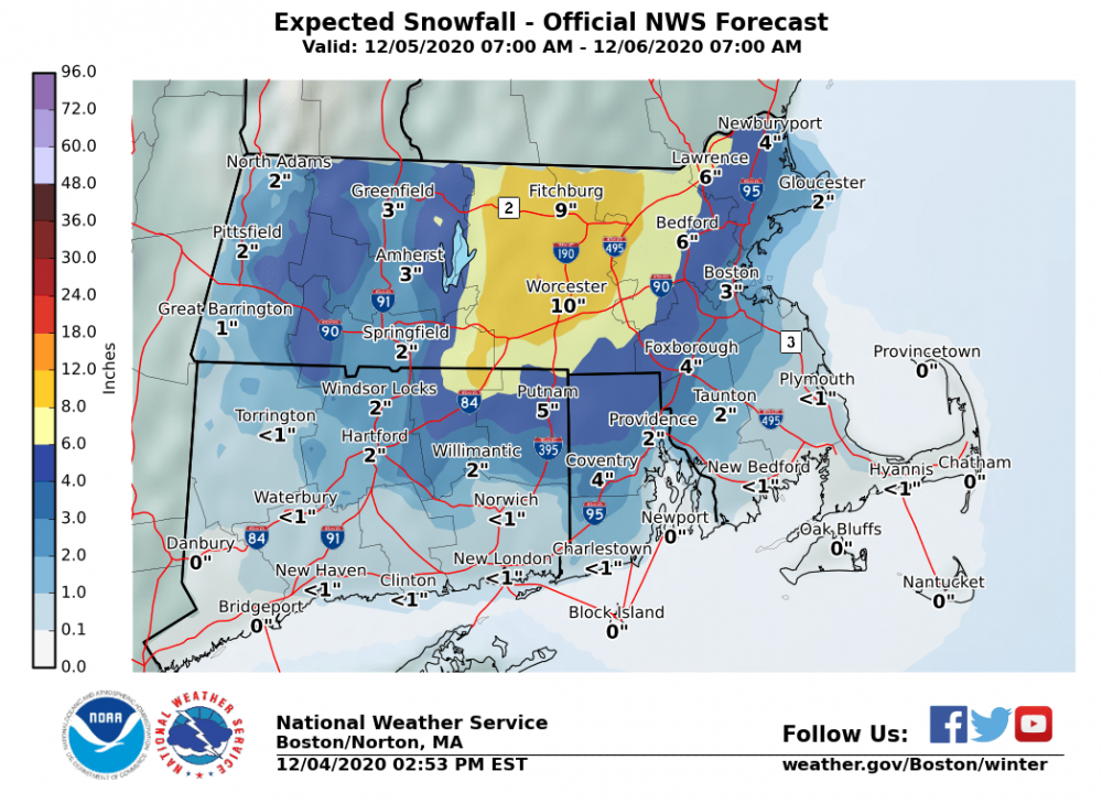
Some NWS maps in case you missed them For Boston metro, flipping an hour sooner/exiting an hour later would be how we can get to 4”+ Some things to watch at 0z, and there was a hint of slower exit on some guidance today

-
Dec 5/6th major coastal/ west Atlantic cyclogenesis ...?
wxsniss replied to Typhoon Tip's topic in New England
All while maintaining dynamics... We were able to thread that needle on some guidance early Thursday. These details still in flux. At the moment I think 2-5" is definitely doable Boston metrowest to 128, coating to 3" southeast. -
Dec 5/6th major coastal/ west Atlantic cyclogenesis ...?
wxsniss replied to Typhoon Tip's topic in New England
-
Dec 5/6th major coastal/ west Atlantic cyclogenesis ...?
wxsniss replied to Typhoon Tip's topic in New England
18z RGEM ticked east, still crazy warm, rain throughout most of SNE -
Dec 5/6th major coastal/ west Atlantic cyclogenesis ...?
wxsniss replied to Typhoon Tip's topic in New England
Yeah the hint of slowdown off the Cape is intriguing for eastern SNE, something to watch in next 12 hours Re: your post on crosshairs... yeah interior eastern SNE (at least 495 and southeast) has never looked ideal in that regard. Best lift is all below DGZ. Snowgrowth might not be optimized, but I'm not familiar if there is something different about stinger mechanics to think that can be overcome. -
Dec 5/6th major coastal/ west Atlantic cyclogenesis ...?
wxsniss replied to Typhoon Tip's topic in New England
These tics make a big difference for Bos metro area coast-128-495... from this NAM run anticipating a changeover somewhere 3-6pm, and an hour here or there will make a difference under those heavy rates Nice to see 18z NAM tic colder Also I think18z NAM slows down the exit a bit -
Dec 5/6th major coastal/ west Atlantic cyclogenesis ...?
wxsniss replied to Typhoon Tip's topic in New England
18z NAM a hair colder than 12z for eastern SNE folks Huge hit for northeast CT-central MA-on northeast -
Dec 5/6th major coastal/ west Atlantic cyclogenesis ...?
wxsniss replied to Typhoon Tip's topic in New England
Boston metro (including metrowest) will be fun to watch ~18z-0z Saturday when 850/925 crash <0C, great rates, but surface is still 37C. I think at the very least, a tight gradient of sloppy coating-2" at coast to 2-4" out by 128. But even an extra 1-2 hours under the best rates would add 1-2", and that's definitely realistic. -
Dec 5/6th major coastal/ west Atlantic cyclogenesis ...?
wxsniss replied to Typhoon Tip's topic in New England
Looks almost identical to 6z Euro... slower gives appearance of a tic West, but I think track looks the same -
Dec 5/6th major coastal/ west Atlantic cyclogenesis ...?
wxsniss replied to Typhoon Tip's topic in New England
Great rain-snow flip story Tip. My fondest memory is still 3/31/97. Awesome storm to track tomorrow. I'm most confident in ORH northeast into NH / ME. Farther west? With this nuking out as quickly as guidance suggests, I'd think western extent of biggest accumulation might not be as far as we'd usually expect from midlevels... Also given how quickly this nukes (and some downstream ridging) I would not be surprised to see a closer track... For Boston metro area / eastern SNE, we were threading the needle of dynamics + temps yesterday with a slightly further eastern track... with these western tics, the 4+ amounts are at risk. Will be extremely close and fun to watch with dynamics, and still think a quick 2-4"/3-6" is possible. Euro has not been jumping around as much as other guidance, let's see... -
Dec 5/6th major coastal/ west Atlantic cyclogenesis ...?
wxsniss replied to Typhoon Tip's topic in New England
12z NAM definitely more N and W compared to 6z A crushing for interior central-eastern SNE -
Dec 5/6th major coastal/ west Atlantic cyclogenesis ...?
wxsniss replied to Typhoon Tip's topic in New England
-
Dec 5/6th major coastal/ west Atlantic cyclogenesis ...?
wxsniss replied to Typhoon Tip's topic in New England
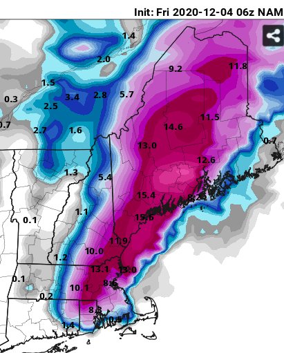
6z NAM much better than 0z NAM... bombs away 36-42hrs for eSNE Similar to 12z 12/3 NAM, but slightly later development which will hurt southwestern folks, but otherwise big hit central-eastern SNE / eastern NH / eastern ME Fair to say the 0z NAM non-event was an egregious outlier