wxsniss
-
Posts
5,799 -
Joined
-
Last visited
Content Type
Profiles
Blogs
Forums
American Weather
Media Demo
Store
Gallery
Everything posted by wxsniss
-
December 5-6, 2020 Storm Observations and Nowcast
wxsniss replied to Baroclinic Zone's topic in New England
Thanks Dendrite I'm assuming all snow parallels somewhere NW of that line (i.e. melting producing rain/mix is occurring below 1500ft, and that sub-1500 ft warm layer is further northwest than the bright band). Matches with that report of mixing in Framingham... did not think we'd breach well into 495 by 18z. Areas between 495 and 128 look to rock in a few hours. -
December 5-6, 2020 Storm Observations and Nowcast
wxsniss replied to Baroclinic Zone's topic in New England
Just catching up (ironically we lost power before the storm courtesy of Eversource, now back)... Friends in Tyngsboro reported 100% snow at 11:30am No question we are ahead of changeover schedule in many places How accurate is dual-pol here? That seems too good to be true / maybe it pivots further northwest before it collapses eastward? -
December 5-6, 2020 Storm Observations and Nowcast
wxsniss replied to Baroclinic Zone's topic in New England
13z HRRR continues to clobber all the way to coast eastern SNE -
Dec 5/6th major coastal/ west Atlantic cyclogenesis ...?
wxsniss replied to Typhoon Tip's topic in New England
-
Dec 5/6th major coastal/ west Atlantic cyclogenesis ...?
wxsniss replied to Typhoon Tip's topic in New England
WSW expanded to include Boston -
Dec 5/6th major coastal/ west Atlantic cyclogenesis ...?
wxsniss replied to Typhoon Tip's topic in New England
6z NAM actually a tic west and warmer than 0z, also maybe a hair faster exit... better for NNE folks, not as good for eastern SNE Still would support a sloppy 2-4" to Boston metro Spots of 20+ in NH, ME -
Dec 5/6th major coastal/ west Atlantic cyclogenesis ...?
wxsniss replied to Typhoon Tip's topic in New England
Let's revisit 7pm tomorrow to see if the changeover has not happened in Boston metro. Haven't seen anyone here tonight say they are expecting the 10:1 snow maps. Likewise, surely you're not claiming the SV maps you posted with 2-4" in ORH is likely. -
Dec 5/6th major coastal/ west Atlantic cyclogenesis ...?
wxsniss replied to Typhoon Tip's topic in New England
Agree, the literal clown maps aren't happening with this antecedent airmass (unless of course this continues to trend east / slower exit). But I'm increasingly confident in 3-6" for Boston metro. Was also thinking earlier about Ray's map that northeast MA could be underdone if exit is prolonged. -
Dec 5/6th major coastal/ west Atlantic cyclogenesis ...?
wxsniss replied to Typhoon Tip's topic in New England
Also the dryslot issues 18z-0z seen on earlier runs are gone... 18z and 0z shown here: -
Dec 5/6th major coastal/ west Atlantic cyclogenesis ...?
wxsniss replied to Typhoon Tip's topic in New England
One reason for bigger totals in eastern SNE is slower exit -
Dec 5/6th major coastal/ west Atlantic cyclogenesis ...?
wxsniss replied to Typhoon Tip's topic in New England
-
Dec 5/6th major coastal/ west Atlantic cyclogenesis ...?
wxsniss replied to Typhoon Tip's topic in New England
Crushing into BOS metro on 0z Euro Jerry will like this at his next pee stop -
Dec 5/6th major coastal/ west Atlantic cyclogenesis ...?
wxsniss replied to Typhoon Tip's topic in New England
Oh absolutely, if we're talking a stretch of weather... Feb 15 no comparison, probably not again in our lifetime. But for a single storm... Feb 15 blizzard is up there, but still did not match the sheer extreme conditions I witnessed Apr 97 and Jan 05 -
Dec 5/6th major coastal/ west Atlantic cyclogenesis ...?
wxsniss replied to Typhoon Tip's topic in New England
Yeah there are several in contention for #3 including Feb 14-15 2015, Mar 13 2018 But I have footage from Jan 05 that I have never witnessed since... near hurricane force winds hard to stay upright + whiteout in Fenway and Harvard Square, single digit temps... it was unreal. I only wish I had footage from April 97... the awe of an earlier changeover in the afternoon, hours of thundersnow at night. -
Dec 5/6th major coastal/ west Atlantic cyclogenesis ...?
wxsniss replied to Typhoon Tip's topic in New England
That is the funniest thing I've seen in a while here... might even make non-weatherbuffs laugh -
Dec 5/6th major coastal/ west Atlantic cyclogenesis ...?
wxsniss replied to Typhoon Tip's topic in New England
April 97 Jan 05 -
Dec 5/6th major coastal/ west Atlantic cyclogenesis ...?
wxsniss replied to Typhoon Tip's topic in New England
...and downstream track ticked southeast. Not sure if any merit until more supporting evidence. EDIT: scratch that, nearly identical location by 21z Sat -
Dec 5/6th major coastal/ west Atlantic cyclogenesis ...?
wxsniss replied to Typhoon Tip's topic in New England
4z RAP vs. 0z NAM continues with less stream interaction comparing at Sat 6z timepoint -
Dec 5/6th major coastal/ west Atlantic cyclogenesis ...?
wxsniss replied to Typhoon Tip's topic in New England
3z HRRR SLP track looks a good bit south of 0z NAM track, probably part of why the changeover happens hours earlier in Boston metro -
Dec 5/6th major coastal/ west Atlantic cyclogenesis ...?
wxsniss replied to Typhoon Tip's topic in New England
Fwiw: 3z RAP vs. 0z NAM for Sat 3z-6z Timepoints: RAP has less H5 N/S stream interaction than NAM -
Dec 5/6th major coastal/ west Atlantic cyclogenesis ...?
wxsniss replied to Typhoon Tip's topic in New England
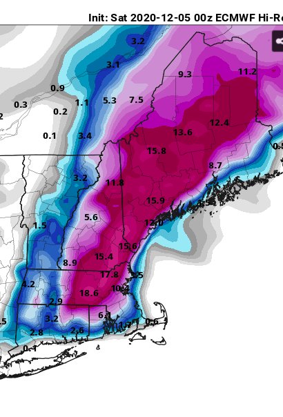
That's a very good map regionwide, and agree with 1-3/3-6 straddling Boston metro -
Dec 5/6th major coastal/ west Atlantic cyclogenesis ...?
wxsniss replied to Typhoon Tip's topic in New England
It's pretty close overall... within range of noise Might also be a tic slower -
Dec 5/6th major coastal/ west Atlantic cyclogenesis ...?
wxsniss replied to Typhoon Tip's topic in New England
0z NAM thru 21 hours... colder profiles for eastern SNE interests, definite tic east -
Dec 5/6th major coastal/ west Atlantic cyclogenesis ...?
wxsniss replied to Typhoon Tip's topic in New England
I saw it on boston.com lol... originally posted on their twitter. Yeah I think I've seen it 1 or 2 times before, so I don't think it's generated for most storms. And obviously not written in stone. Will be a fun afternoon nowcasting! -
Dec 5/6th major coastal/ west Atlantic cyclogenesis ...?
wxsniss replied to Typhoon Tip's topic in New England
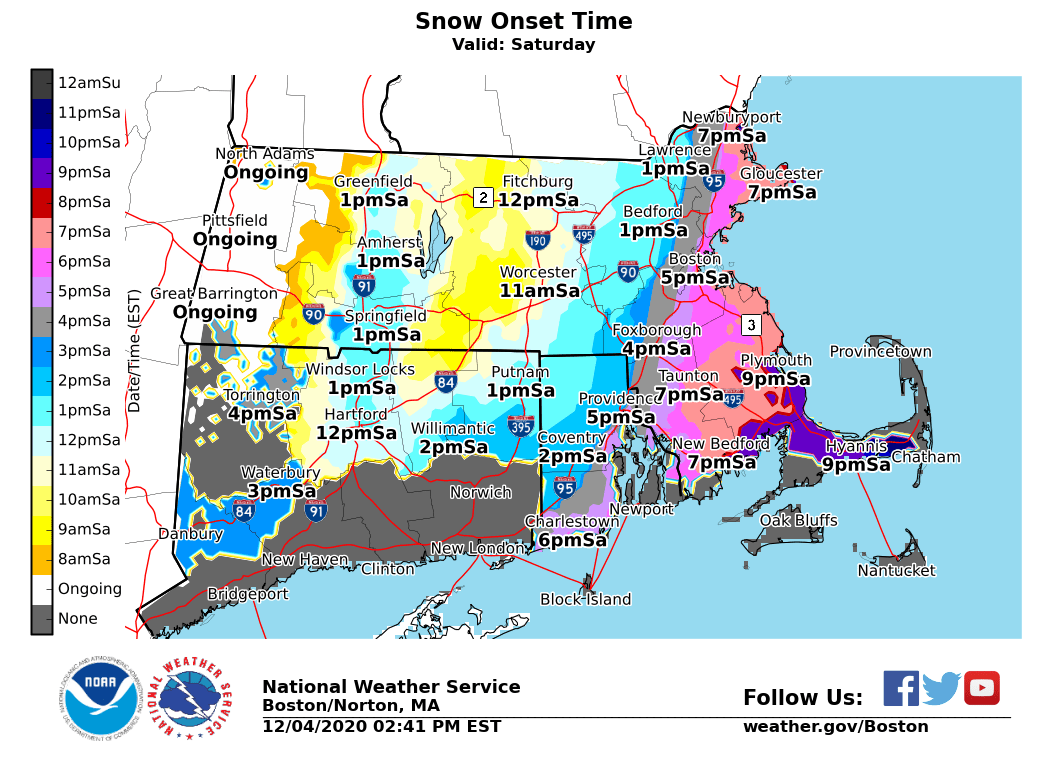
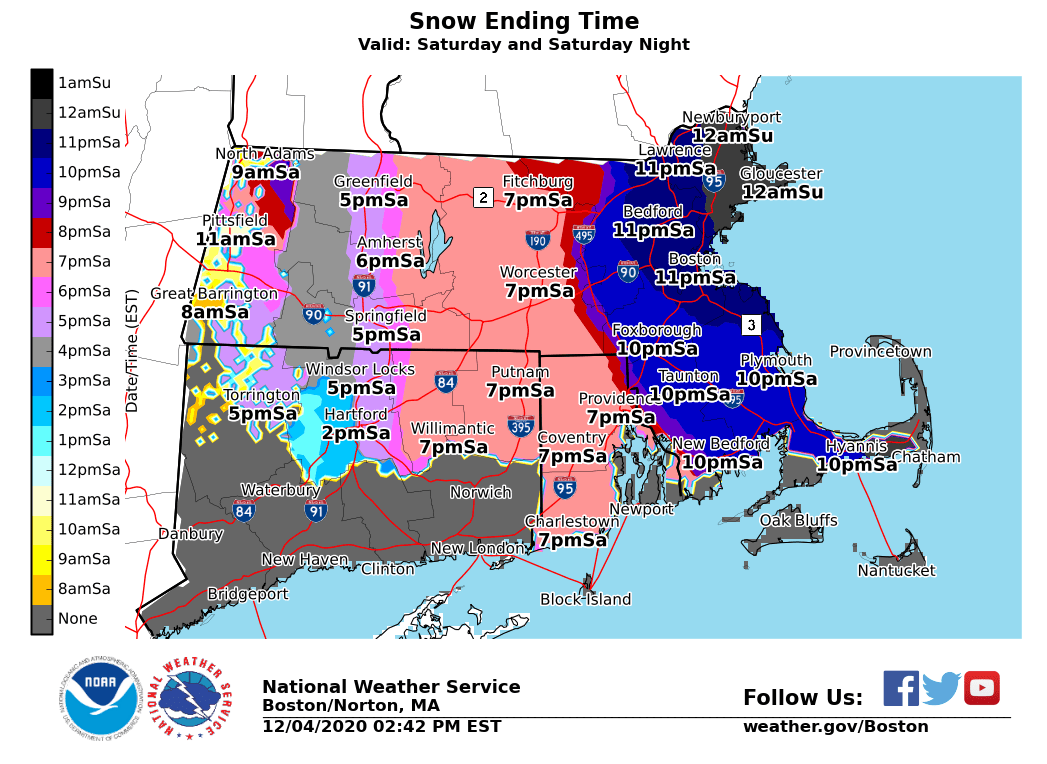
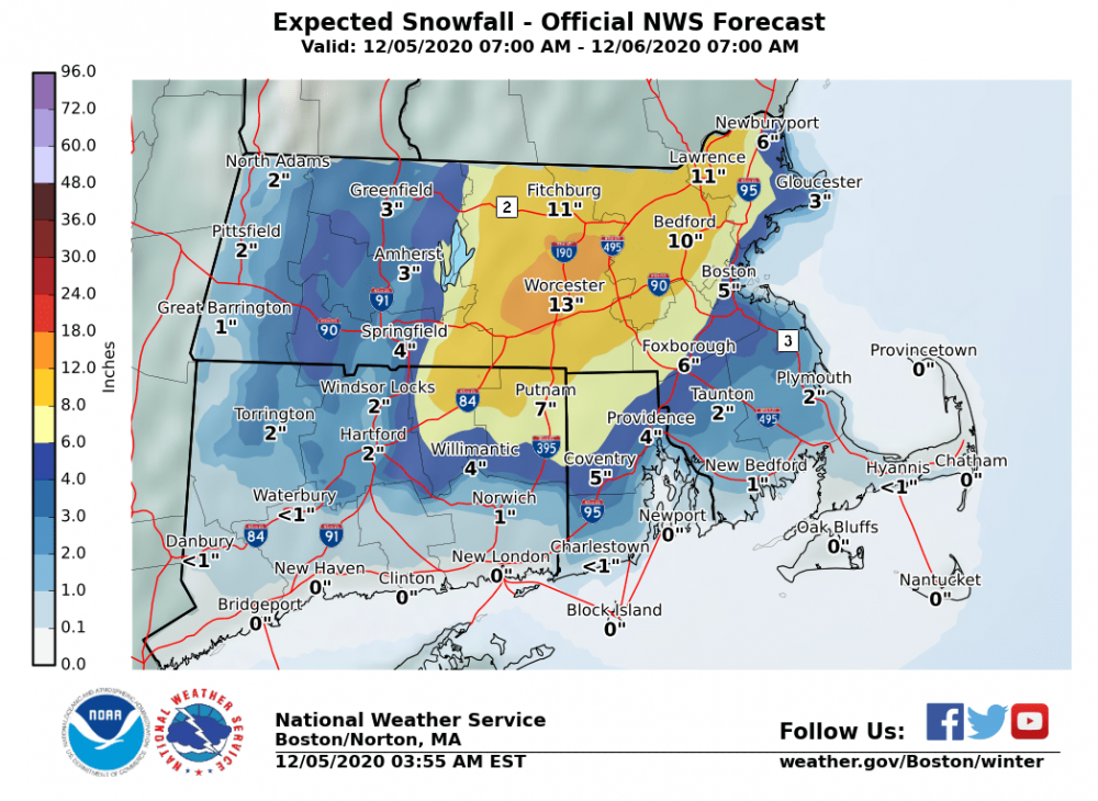
Some NWS maps in case you missed them For Boston metro, flipping an hour sooner/exiting an hour later would be how we can get to 4”+ Some things to watch at 0z, and there was a hint of slower exit on some guidance today