

wxsniss
-
Posts
5,787 -
Joined
-
Last visited
Content Type
Profiles
Blogs
Forums
American Weather
Media Demo
Store
Gallery
Everything posted by wxsniss
-
Significant upper middle Atlantic S/CNE mix/snow potential Jan 3+
wxsniss replied to Typhoon Tip's topic in New England
Cool to see the simultaneous OES echoes and storm echoes moving in opposite directions -
Significant upper middle Atlantic S/CNE mix/snow potential Jan 3+
wxsniss replied to Typhoon Tip's topic in New England
34F, decent wet flakes on this side of the CF. Actually quickly whitening cars under these 30 dBZs! To quote Jerry, "this is what it's come to?" -
Significant upper middle Atlantic S/CNE mix/snow potential Jan 3+
wxsniss replied to Typhoon Tip's topic in New England
Disparate pockets of moisture? -
Significant upper middle Atlantic S/CNE mix/snow potential Jan 3+
wxsniss replied to Typhoon Tip's topic in New England
It was always a precarious setup, but wow what a poor showing for Euro within 24 hours of start... Maybe you can fudge the advisory level solutions in SNE, but look how drastically it changed in Maine. -
Significant upper middle Atlantic S/CNE mix/snow potential Jan 3+
wxsniss replied to Typhoon Tip's topic in New England
I don't mind the map, as much as the fact that it somehow represents the primary forecast (vs. NWS) to the entire Boston.com audience, and also that he hates snow. I love it when he busts too low. -
Significant upper middle Atlantic S/CNE mix/snow potential Jan 3+
wxsniss replied to Typhoon Tip's topic in New England
Agree, same impression off 12z Euro This 18z was a big run... Euro has been on its own this afternoon -
Significant upper middle Atlantic S/CNE mix/snow potential Jan 3+
wxsniss replied to Typhoon Tip's topic in New England
Not so great on this particular run and disappoints the ME crowd, but the capture is probably still too sensitive and distant to pin down now -
Significant upper middle Atlantic S/CNE mix/snow potential Jan 3+
wxsniss replied to Typhoon Tip's topic in New England
Yeah great to see 18z Euro double down on its 12z run... Euro is kind of on its own here with the 3-6/4-8 amounts into eastern MA, but I weigh it more than the rest. -
Significant upper middle Atlantic S/CNE mix/snow potential Jan 3+
wxsniss replied to Typhoon Tip's topic in New England
Looking at all the 12z/18z guidance so far... Only the 12z Euro (and 18z HRRR, well out of range) and EPS support the higher 3-6/4-8 amounts in eastern SNE... if it were any other model going against the consensus, we'd toss it. Fair to weigh it more heavily at the moment, but it will need to double down at 18z / 0z. Otherwise the Box map is looking about right. -
Significant upper middle Atlantic S/CNE mix/snow potential Jan 3+
wxsniss replied to Typhoon Tip's topic in New England
Unfortunately just 1 run of the Euro... great trend, but guidance is still all over to be completely certain with this For eastern SNE, the crappy air mass also makes me hesitant of widespread 3-6/4-8" until we're more confident of the better dynamics -
Significant upper middle Atlantic S/CNE mix/snow potential Jan 3+
wxsniss replied to Typhoon Tip's topic in New England
For SNE, pretty sizable discontinuity on 12z Euro compared to 0z / yesterday's 12z... This 12z run finally has a more expected distribution of dynamics and QPF you'd expect with a SLP tracking over the benchmark. By 18z Mon, with an H5 low now closing completely off the Cape compared to over SNE in prior runs, might expect even more further NW of that into SNE and eventually eastern NH / eastern ME. -
Significant upper middle Atlantic S/CNE mix/snow potential Jan 3+
wxsniss replied to Typhoon Tip's topic in New England
And also how difficult it is to prognosticate based on upstream features... Usually we can make predictions "this run will be better/worse based on x"... I haven't followed as closely, but this event is so dependent on tiny nuances of position and timing of a capture, and it's more difficult to pick up trends and key determinants. You could see 0z Nam would be further southeast with best baroclinicity farther out, but it still captures and loops back to hit ME. -
Merry Christmas and happy holidays all! Good riddance to 2020, and here's to having a place where, year after year, ratters or epicosity, we can escape in love of weather.
-
I pulled up soundings for that exact location and model... DGZ = 16091 - 2415 = 13676 feet !!! Someone at Okemo could sneeze up and it would snow. But still puzzled by soundings at Binghamton (I posted above)... DGZ throughout the event on multiple models was only ~ 3000 feet... not particularly deep. Either model soundings were not accurate (e.g., H85-H7 temps were much colder than progged), or combination of extreme lift + great ratios was enough.
-
0z Euro Thurs (event already underway) had a decent Kuchera map... QPF in the fronto band ranged from 1-1.7, so with ratios up to 20:1, you might see how you could get to 40": (note... no Euro run before this had anything close to reality... models massively missed a historic weather event for PA-NY-VT-NH):
-
Yeah it's a puzzle... looking back at soundings from Thurs 0z 3k NAM / 12k NAM (can't see HRRR that far back): 6z Thursday night, under the heaviest band near Binghamton... insane lift, but not an especially deep DGZ:
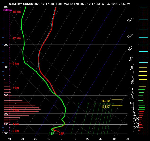
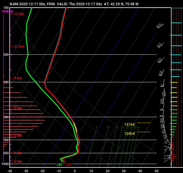
-
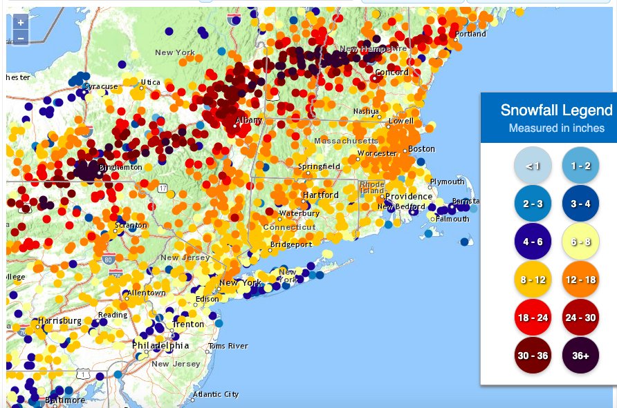
https://www.weather.gov/source/crh/snowmap.html
-
What an awesome storm... that WCB band through eastern MA 1-2am was one of the best I've seen in 25+ years in Boston Multiple different mechanisms on display (WCB, mid-level frontogenesis, CCB) more geographically disjointed than what I'm used to seeing This season already a great start with 2 over-performers (Oct 29, Dec 16), 1 big bust (Dec 5) Still don't understand why not a single model had any clue on that mid-level fronto being so far northwest, intense, and stationary... do we know if the track of the ULL was very different than progged? Haven't had time to go through guidance vs. mesoanalysis to understand what happened.
-
Yeah Jay 1-2am was one of the most intense WCBs I’ve ever seen in the Boston area Visibility down to a few hundred yards, rates of 2-4” / hr I’m failing to upload a movie clip in the max space allowed, and YouTube resolution is bad This photo does no justice... a fog of heavy snow, big flakes:
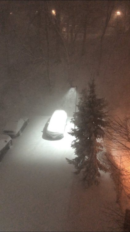
-
It's crawling... so far not the same visibility and snowgrowth that we had 1:30am... wonder what obs are south of the city where returns are better
-
NWS twitter confirms we were getting 2-3"/hr in that first band, not surprised at all https://twitter.com/NWSBoston/status/1339462076847144962?s=20 7z HRRR soundings continue great for next 2-3 hours
-
Next mega band approaching Boston area... wonder if Jerry wakes up to see it 12:30-2am was incredible, heaviest rates we've had in years, several hundred yard visibility for hours
-
Seriously wondering about approaching blizzard criteria... hours of < 1/4 visibility, already occasional gusts > 35 at KBOS...
-
0z Euro agrees, no major changes Surpassing my expectations Visibility easily < 1/4, and this has been going on for > 1 hour so far... I'm wondering how close we will be to blizzard criteria... seems like only winds might fall short, but they will pick up through the night, already gusts to 37 at KBOS
-
Wow this is really, really impressive... Can't wait to see Jerry's reaction when he wakes up Must be years since we've had these steady heavy rates in Boston metro Easily < 1/4m visibility


