

wxsniss
-
Posts
5,788 -
Joined
-
Last visited
Content Type
Profiles
Blogs
Forums
American Weather
Media Demo
Store
Gallery
Everything posted by wxsniss
-
"Don’t do it" 2026 Blizzard obs, updates and pictures.
wxsniss replied to Ginx snewx's topic in New England
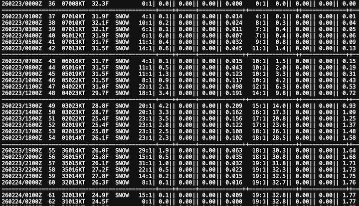
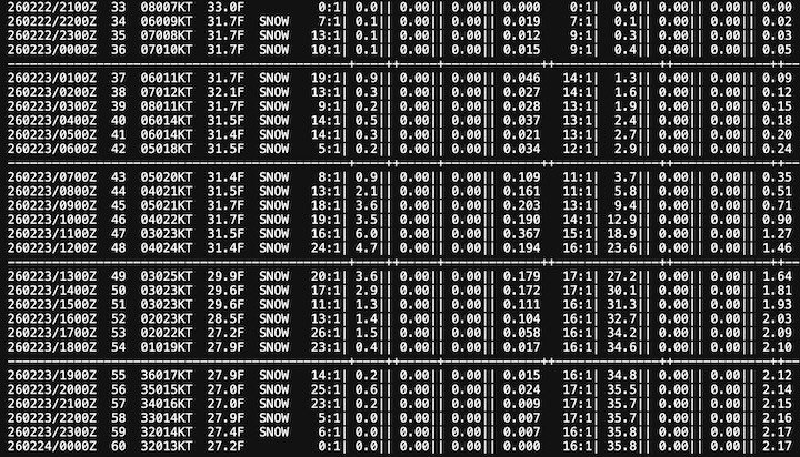
Mesoscale Discussion 0116 NWS Storm Prediction Center Norman OK 1145 PM CST Sun Feb 22 2026 Areas affected...New York City Vicinity into southern New England Concerning...Blizzard Valid 230545Z - 231045Z SUMMARY...Moderate to heavy snowfall will continue from the NYC Metro vicinity into southern New England. Snowfall rates of 1-2 inches per hour are likely with localized 2+ inches per hour possible. Greater rates will spread north with time. Blizzard conditions will also become more prevalent, particularly near the coast. DISCUSSION...Over the past 5 hours, the surface cyclone off the Mid-Atlantic coast has deepened approximately 9 mb per objective analysis. Bands of moderate to heavy snow continue to pivot into the NYC metro vicinity as well as southern New England. Moderate snow observations are beginning to occur into Massachusetts. As the upper trough continues to intensify and become more negatively tilted, the surface cyclone will deepen further into Monday morning. A long duration of at least moderate snowfall can be expected. Closer to 4-7 AM EST, a zone of very favorable ascent is expected to set up over southern New England. Snowfall rates of 1-2 inches per hour are likely along with the potential for localized 2+ inches per hour. Greater snowfall rates will also gradually shift northward as the system slowly lifts northeastward. Beyond significant snowfall rates, surface winds have already begun to increase from the Mid-Atlantic into southern New England. Current observations show winds gusting into the mid 30s to low 40s kts in Long Island. This trend should continue over the next several hours. Blizzard conditions will remain more likely near the coast, but inland areas will become increasingly impacted by strong winds and reduced visibility later this morning. ..Wendt.. 02/23/2026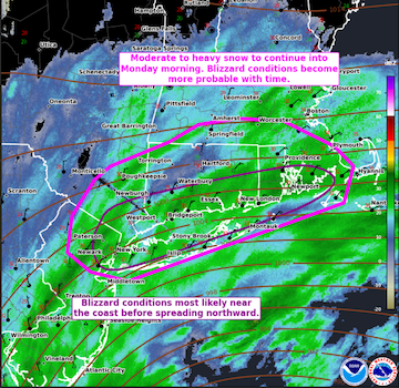
-
"Don’t do it" 2026 Blizzard obs, updates and pictures.
wxsniss replied to Ginx snewx's topic in New England
Commiserating for you that an all-timer is uncertain, but I don't think it's all lost yet. Eg. 01z NBM hourly rates accurately depicts the intense rates in Delaware, but then pivots the best fronto to south coast by 5AM, and crushes eastern/southeastern MA 7a-1p Are you staying in Chestnut Hill? Really picked up here in Brookline in past 30 min, moderate and roads covered -
"Don’t do it" 2026 Blizzard obs, updates and pictures.
wxsniss replied to Ginx snewx's topic in New England
01z NBM held steady... will be a stark test of what this is worth, if anything...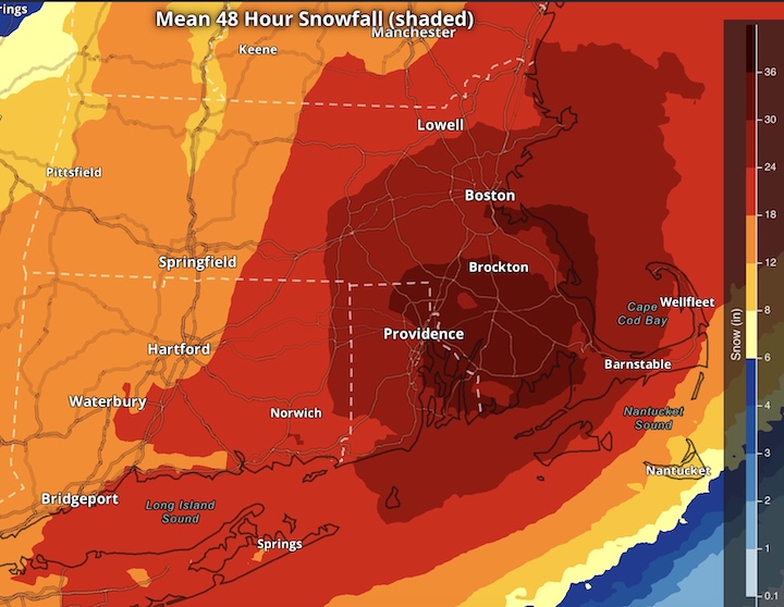
-
"Don’t do it" 2026 Blizzard obs, updates and pictures.
wxsniss replied to Ginx snewx's topic in New England
Gives hope we can at least salvage 12-20 BOS-PVD and southeast -
"Don’t do it" 2026 Blizzard obs, updates and pictures.
wxsniss replied to Ginx snewx's topic in New England
Still light snow at best just outside Boston, barely a coating... ground truth has not matched radar so far Philly thread is a great read... the H7 / H85 fronto off of Delaware is amazing 4z HRRR cut back even more here -
"Don’t do it" 2026 Blizzard obs, updates and pictures.
wxsniss replied to Ginx snewx's topic in New England
Aside from the fronto bands moving north, I think you can see influx of echoes blossoming off the ocean Finally some steady light snow and blustery in Brookline just west of city Just catching up, want to compare mesoanalysis with upstream obs... hoping that h7 / h85 fronto off DE/NJ translates up here as low deepens -
Pretty exotic don't remember seeing so many mesolows gyrating around like that outside of TCs Haven't had a chance to post or look at upstream data... grocery stores are insane right now and progged winds are giving me serious worries about power loss. NAMs / HRRRs look excellent 19z NBM for any curious... (note straddles 48h period so I posted both below)... whatever cocktail of models it ingested, it's held steady:
-
https://sites.gsl.noaa.gov/desi/
-
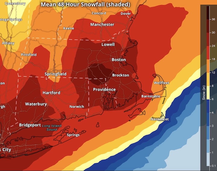
01z Feb 22 NBM (takeaway being that it trended up ingesting the evolving mix of models):
-
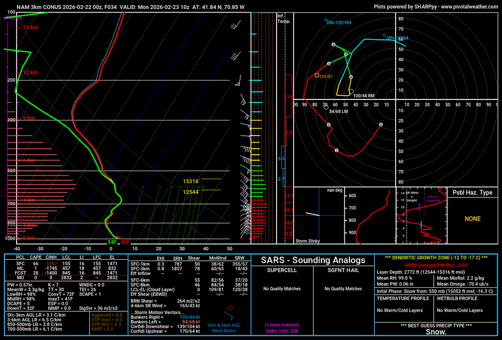
Some freak soundings on that 0z 3k NAM... this is in southeast MA (though not the biggest DGZ):
-
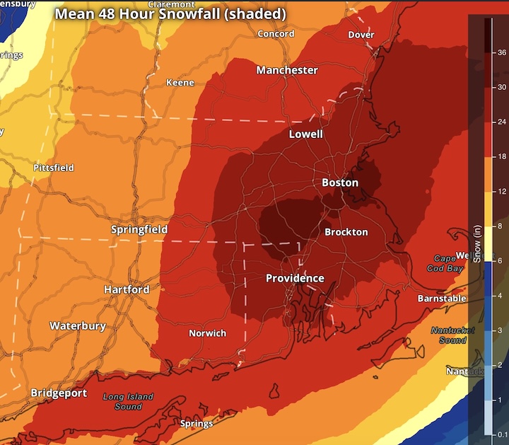
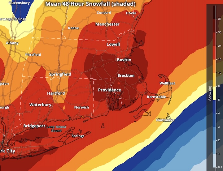
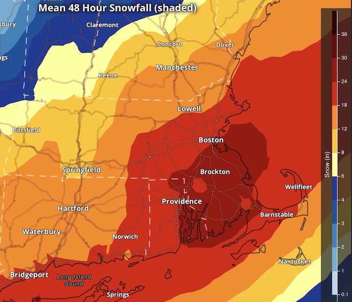
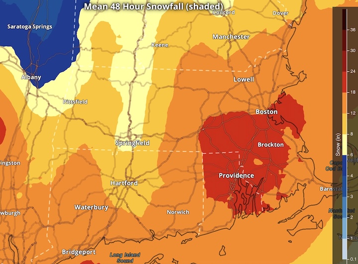
Legendary move by a legendary OG poster for what looks to be a legendary storm. A few key synoptic variables in flux to determine place in history is timing of maturation... yesterday trended later / better for SNE vs. today trended a bit earlier / better for Philly/NYC/LI... could be in flux through Sunday. And obviously track... today maybe trended better tucking more NW on mesos. 19z NBM output... along with the winds, this is shaping up to be historic:
-
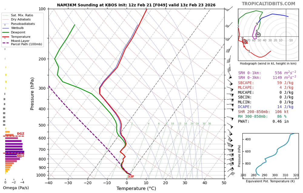
Monday morning KBOS on 3k NAM:
-
So much to archive, we're living another museum piece... Didn't see @Ginx snewx post this earlier, KBOS and KPVD Bufkit from 12z GFS: KBOS KPVD
-
1z Feb 21 NBM output 48 hours ending 1am Tuesday. Yeah we're going there. Box will likely have big headlines Saturday.
-
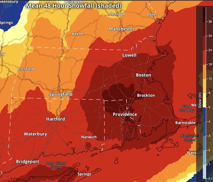
What an unmitigated, lights-out, absolute coup for the GFS / AI-GFS. I can't remember another case where the stakes were this big, the camps were initially so stubbornly dissimilar, the GFS was on its own... and the GFS schooled everyone. Assuming the big hit verifies, but I have zero doubt it will. 19z NBM (48h ending 7pm Monday):
-
Just back from Disney, lots of tracking waiting in lines all week GFS / AI GFS led the way and wow 6z ticked even further NW blizzard for southeast portions at least 970s tracking closer to BM Warning much of SNE foot+ ORH east
-
Great signals for last half of February on guidance across the board including ensembles and AI This winter has a sneaky epic vibe I'll be out of town with the kids for school vacation week next week... perfect timing not to miss the potential ahead
-
Feb 10-11 Mid Week Minor Event - Ride the hot hand?
wxsniss replied to HoarfrostHubb's topic in New England
updated KBOS 1.9" for last night I believe that brings season total to 41.4" (normal to date 30.2") With the sustained deep cold and massive piles, what an unmitigated stretch of yore since the Jan SWFE, nothing close since 2015 -
Feb 10-11 Mid Week Minor Event - Ride the hot hand?
wxsniss replied to HoarfrostHubb's topic in New England
KBOS event tonight 1.6” season 41.1” Feels good to be back -
Feb 10-11 Mid Week Minor Event - Ride the hot hand?
wxsniss replied to HoarfrostHubb's topic in New England
~Providence to Plymouth line looks great for 2"+ Mostly stopped here for now... 1.2" near Coolidge Corner in Brookline Maybe we can tack on another 0.5" with cell currently near Worcester -
Feb 10-11 Mid Week Minor Event - Ride the hot hand?
wxsniss replied to HoarfrostHubb's topic in New England
Heavy snow! Good flakes Roads completely white Coolidge Corner -
Feb 10-11 Mid Week Minor Event - Ride the hot hand?
wxsniss replied to HoarfrostHubb's topic in New England
Was gonna post you a headsup earlier... I'm located maybe ~15-20 min ahead of you? 2z HRRR dries up the stuff after 5z (prior runs had continued snowfall 5z-8z)... even if correct, 2 hours of this and we can get 2"+ -
Feb 10-11 Mid Week Minor Event - Ride the hot hand?
wxsniss replied to HoarfrostHubb's topic in New England
Sidewalks covered in 10 min, roads starting to whiten 2 hours of this should get us to 2"+ -
Feb 10-11 Mid Week Minor Event - Ride the hot hand?
wxsniss replied to HoarfrostHubb's topic in New England
Borderline heavy here near Fenway -
Feb 10-11 Mid Week Minor Event - Ride the hot hand?
wxsniss replied to HoarfrostHubb's topic in New England
Near Fenway: Nice moderate snowfall with great dendrites for 20 min with that band earlier, put down a fresh coating Radar looking not meager over eastern NY, expecting ~2-3" here


