Jonathan
-
Posts
1,469 -
Joined
-
Last visited
Content Type
Profiles
Blogs
Forums
American Weather
Media Demo
Store
Gallery
Everything posted by Jonathan
-
HP 1mb weaker on GFS...THAT'S been a trend we don't want to see.
-
So when do we start looking for trends in the NAM past 60hr? Never? lol
-
Heck, at this point, I'm beginning to worry about mixing down this way. Really need that FV3 to show us why it's replacing the GFS with this one.
-
Upper air pattern way more important that what the models paint at the surface. If we're similar at 500mb maybe stray away from the cliff for now.
-
0z runs are gonna be a BIG YIKES across the board. Confetti rains in the MA forum...
-
Here we go... everything north so far. After a day of miller A's, miller B is back on the table.
-
And I'll take your north shift and raise you one more. Just don't tell @Buddy1987 or @Disc !
-
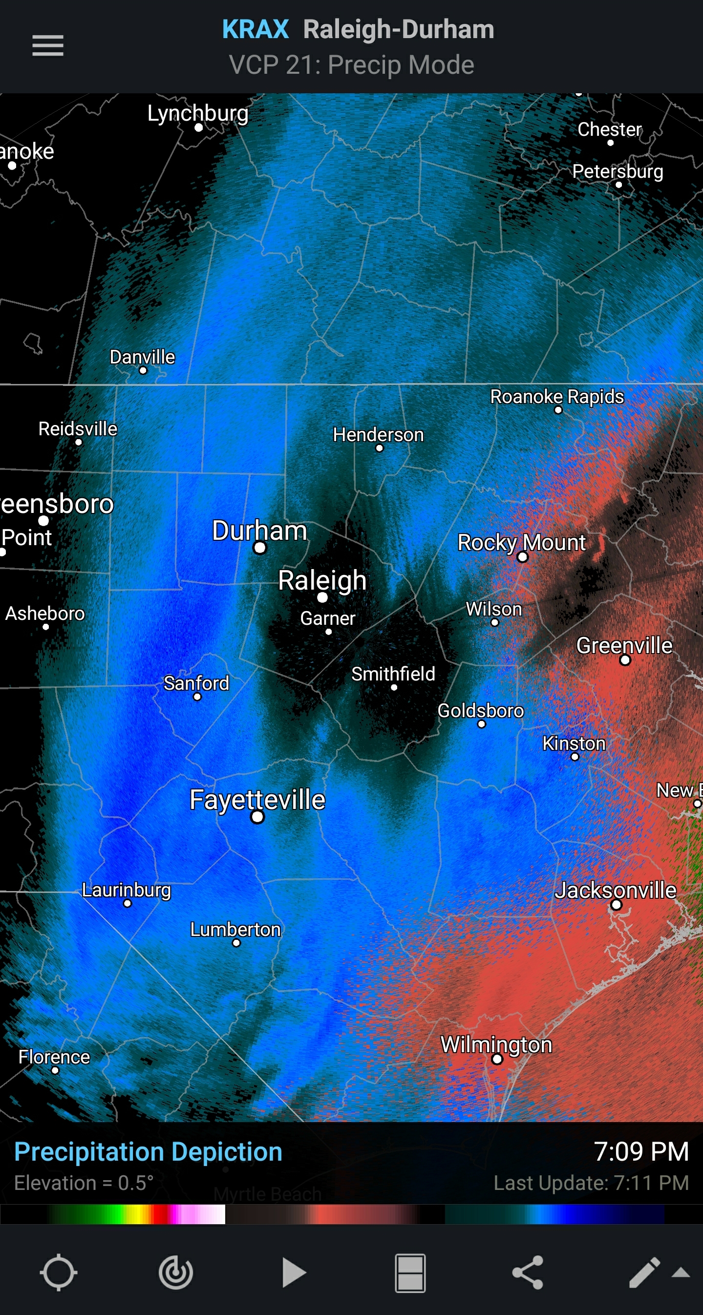
Total whiff for everyone north of Raleigh and GSO. Congrats, guys! You finally get your big one! Long overdue for so many. Glad to see you boys score!
-
I wouldn't be concerned either if I were in Salem! I worded that wrong. I guess what I was trying to say was instead of a hostile WEATHER PATTERN, it's a hostile timeframe on the models. It's almost time for them to drop it completely, cause mass panic and pick it back up in 24 hours.
-
Damned Vikings! As Jeremy mentioned folks, we've lost several storms in the 5-7 day range that never came back. Even me in SW VA. We have a LONG way to go in a fairly hostile pattern.
-
That's not very nice, grit! What comes will come, and we will take it. I will chase if need be.
-
Gonna go ahead and get the heat running here in the sanitarium. Gonna be a packed house soon!
-
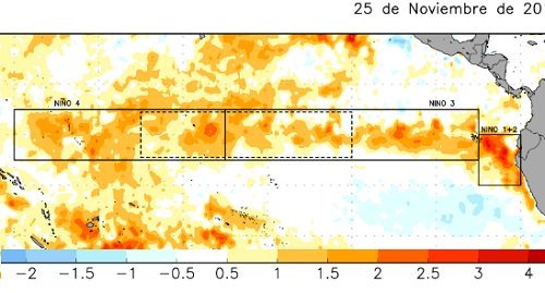
BASIN-WIDE SUPER NINO PT. II INCOMING kiss all those cold, snowy forecasts goodbye, folks!
-
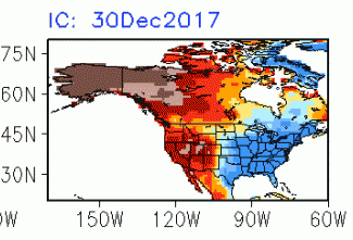
Yep. Our elusive modoki Nino is off the table. We're in a basin-wide event with no looking back. EPS has flipped to a terrible Pacific pattern in the LR. Winter is over before it ever began! All those cold forecasts are toast!
-
CAN IT PLEASE STOP RAINING ALREADY?! I AM ABSOLUTELY S I C K OF IT!!!!!!!!!!! IT RAINS EVERY FRIGGIN DAY FROM NOON TIL 6:00!!!!!! HAS BEEN SINCE MID-JULY!!!!!!! STOP!!!!!! PLEASE!!!!!!!!! Ok I feel better.
-
-
-NAO -NAO -NAO -NAO -NAO Yes, having a +PNA is wonderful. We need it. It's imperative. Combine that with a -EPO and we can get (and stay) cold as we just seen. -AO? You bet, we need it. -PNA/-AO combination is paramount. But we have seen over and over and over and over again the importance of a -NAO. If we have to rely SOLELY on TIMING a HP moving in tandem with a wave all the way across the nation to score, well, the results speak for themselves. We can score with the +PNA/-AO combo, and we have (DEC 8) but in order to get more of the SE involved, we MUST have a -NAO to slow the flow so we don't HAVE to rely solely on timing. Even if it's just for a few days (and most of the time since 2009, we've only had it for a few days at a time.) we absolutely must have it to score widespread across this forum. If we have a +PNA/-AO combo, we have about a 10% chance of a widespread, legit winter storm. Give us a -NAO and I'd say that increases the chance to closer to 50%.
-
Screw it, I'm moving to northern Kentucky. They always seem to rack up, especially since 2010. They get FROPAs, clippers, cutters and phasers. Plus, they're always colder than anywhere east of the Apps.
-
I know you already know this, but even though the quote...wait for it...one of our favorite words here..."VERBATIM" is false, we (west of Raleigh) did see how an overly COLD *pattern* can indeed squash (literally and metaphorically) the hopes and dreams of any snow in (most of) the southeast. No one outside of the beaches/far eastern areas had a chance with the PV and those insane HPs destroying any chance of a widespread winter storm. So even though taken literally the quote is wrong, it's not THAT wrong. Those folks were indeed in a similar type of pattern where it was super cold and they didn't see snow in those particular periods. Since there are no storms to analyze, we may as well analyze old wise tales, etc.
-
I think all members south and east of RDU should leave the board for ten years.
-
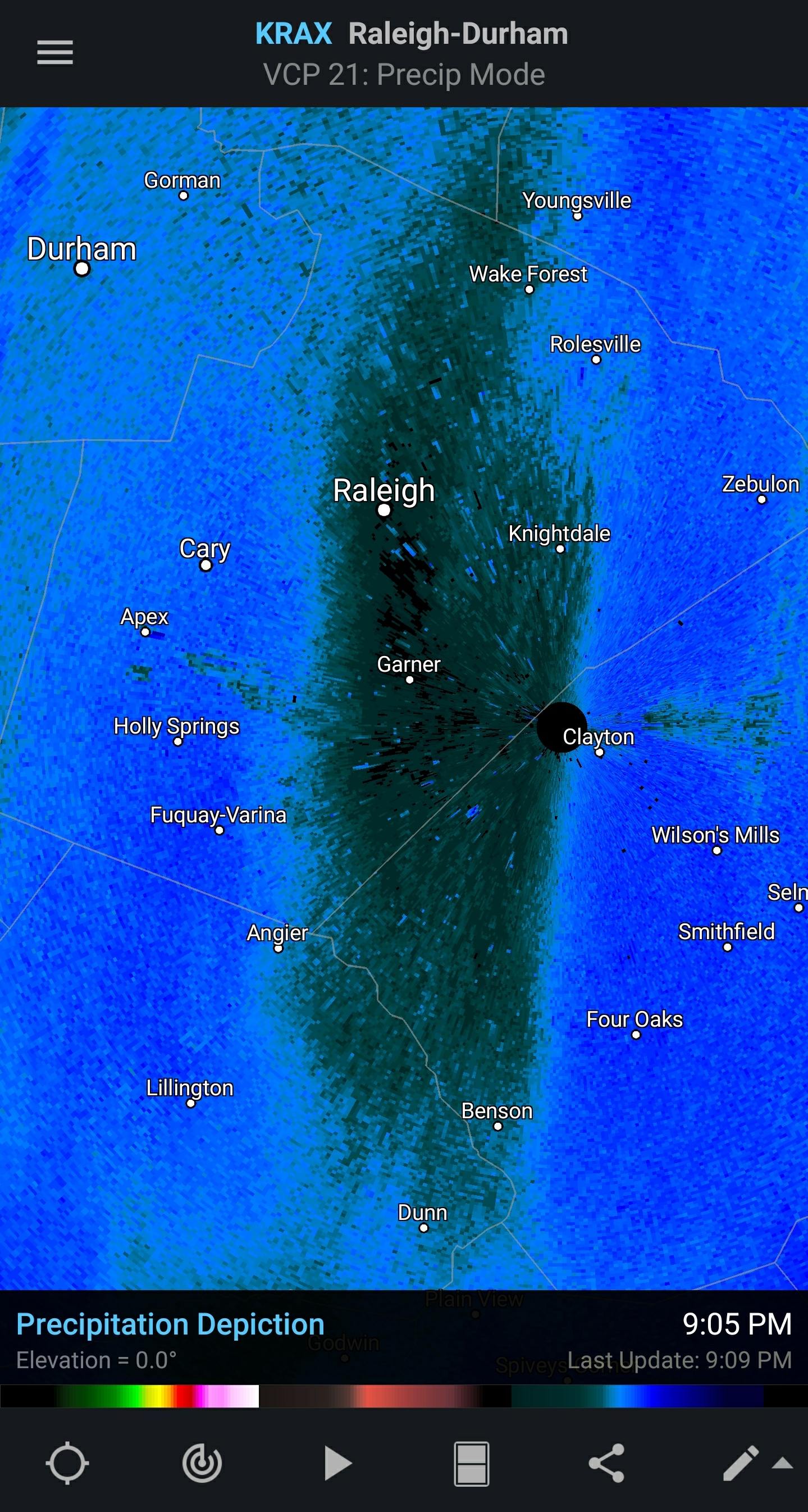
Why I'm pissed FOR anyone on this board inside this circle. Hopefully most are seeing snow on either side of Raleigh. This is insane.

-
Lucky. ~50 miles to your NNW, nothing.
-
Please tell me this isn't real. Jesus you guys.

-
inb4 "the EURO ain't what it used to be!" posts
-
CFS's got you fam! Gonna be a Jammin' January!