Jonathan
-
Posts
1,469 -
Joined
-
Last visited
Content Type
Profiles
Blogs
Forums
American Weather
Media Demo
Store
Gallery
Everything posted by Jonathan
-
Of course the Euro is beautiful, but we still had north trends on the before rock-solid FV3 and the wishy washy Canadian. I don't like that all of a sudden we have this northern stream energy to throw a wrench in this deal. That's going to cause madness the next 48 hours.
-
Jonathan, your stormvista maps are way ahead of WxBell, how's it look across the border around and west of Martinsville? I see sleet creeping to the border on WxBell maps.
-
BURGER BOOM ENGAGE
-
You'd think it'd be better as we approach January when it takes over. I guess we wait til 5:00PM for frame hr102.
-
Good point, sir. I am guilty of "quickly" rushing through surface output rather than MSLP anomalies, etc.
-
You can say what you want Jeremy but the EURO was much further north and 4-5 degrees warmer across the board. It was 3am and I was squinting at a cellphone. Totals cut, temps higher, more phasing. It was "OK" but it wasn't pretty or a continuation of our "southern slider" it'd previously been showing.
-
I have a feeling that even I am gonna have mixing issues here across the border. ROA-DCA will end up jackpotting, you watch.
-
It was 4-5 degrees warmer hours 132-144 for my area and lots of others. That stinks.
-
I just thought overall it was a little more amped and warmer than we'd like to see. It definitely doesn't slide west to east, noticeable north jump this go round. Onto the ensembles...
-
I guess overall, this is probably more realistic. Fantasy playtime is over outside of the mountains.
-
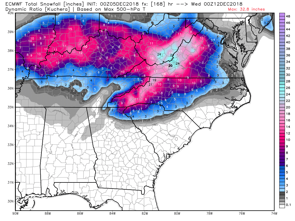
Verbatim with Kuchera ratio still 12"+ in the mountains, 20"+ near Roanoke VA, only 6-8" in the foothills, 2-6" Piedmont, 0-1" for Raleigh. EDIT: an additional 1-3" on the back side for the Piedmont, gets Raleigh to 2-5"
-
*turns on lights, starts coffee maker* Ah, this morning should be a doozy! Gonna be DEFCON 1 in the SE forum in a few hours!
-
At that particular hour, sure. I'm on wxbell and the low tracks from SC off the VA coast...yuck
-
The low is just north of Hatteras at 132...was near Wilmington on the 12z. Even Virginia rains. That high pressure gets broken down like a double barreled shotgun.
-
Yikes...the euro is WAY north...HUNDREDS OF MILES north...ouch
-
I see Brandon @HKY_WX lurking. Interested in your current thoughts sir.
-
It's ok, it's just the crazy 6z...
-
The euro is an entire day slower than the GFS/FV3. That's a pretty striking difference in the model suites and guessing that's why the EURO is warmer, even though it improved a tick this morning.
-
HP 1mb weaker on GFS...THAT'S been a trend we don't want to see.
-
So when do we start looking for trends in the NAM past 60hr? Never? lol
-
Heck, at this point, I'm beginning to worry about mixing down this way. Really need that FV3 to show us why it's replacing the GFS with this one.
-
Upper air pattern way more important that what the models paint at the surface. If we're similar at 500mb maybe stray away from the cliff for now.
-
0z runs are gonna be a BIG YIKES across the board. Confetti rains in the MA forum...
-
Here we go... everything north so far. After a day of miller A's, miller B is back on the table.