dendrite
-
Posts
73,513 -
Joined
Content Type
Profiles
Blogs
Forums
American Weather
Media Demo
Store
Gallery
Everything posted by dendrite
-

Clipper Fires In Wednesday Feb 25 Disco/ Obs
dendrite replied to Damage In Tolland's topic in New England
Latest HRRR modeled snowfall…fwiw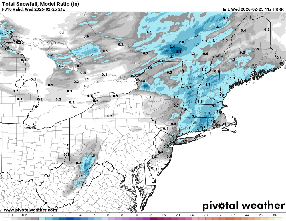
-
Clipper Fires In Wednesday Feb 25 Disco/ Obs
dendrite replied to Damage In Tolland's topic in New England
9.7° -SN Good growth -
"Don’t do it" 2026 Blizzard obs, updates and pictures.
dendrite replied to Ginx snewx's topic in New England
The thing is PVD measures snow pack water equivalent daily at 18z. In the METAR look for the 933rrr remark code which is reported in tenths of inches. The problem is they presumably lost 1.4” of liquid in the pack from 18z Mon (during +SN) to 18z yesterday. 22nd 1.5” 23rd 4.1” (+2.6”) 24th 2.7” (-1.4”) If you’re going to roll with 38” then at least 2.6” w.e. plus whatever the ASOS recorded after that makes a good estimate. KPVD 221751Z 08009KT 10SM OVC025 01/M04 A3011 RMK AO2 SLP195 4/005 933015 T00061039 10011 21011 56019 $ KPVD 231751Z COR 36028G40KT 1/4SM +SN BLSN FZFG VV007 M04/M05 A2928 RMK AO2 PK WND 36040/1751 SLP914 SNINCR 4/37 P0003 60017 4/037 933041 T10391050 11006 21039 53003 RVRNO $ KPVD 241751Z 33010G18KT 10SM FEW020 FEW250 M01/M12 A2977 RMK AO2 SLP081 4/032 933027 T10111117 11011 21050 58005 -
- 263 replies
-
- 10
-

-
Nah he’s primed and ready to dry my well this spring.
-
Nah. We up here.
-
"Don’t do it" 2026 Blizzard obs, updates and pictures.
dendrite replied to Ginx snewx's topic in New England
I was worried about dry air lurking to the north most of the week as the confluence from that s/w backing in from ME was slow to lift out. Sunday morning I just knew it was going to be a problem when I saw how much the dry air was putting up a fight with the cloud cover. -
I did release a balloon of helium, and lo, much to mine astonishment, after tracking southwestward o’er Elmer’s tannery a mere 200 rods hence, the thing did change course and return o’er my own abode, shrinkin’ to a size o’ a bee in the heavens.
-
SW flow aloft yes. It was N-NE flow at the surface. But in the knickers days they wouldn’t have really known the difference between a coastal and a strong overrunning event like 1/25 unless someone had access to a barometer and pressure readings in the region.
-
Does someone actually hang around CPK all day to measure?
-
Yeah I ignored the bad data.
-
If they cleared for the 18z ob (idk what they do there but I assume there’s a contract observer) they may have lost any additional due to melting/melting on contact by the time they measured again. I think the temp climbed from 31-33 in that period and eventually to 34 by 00z.
-
It would’ve been called nor’easter in the yore years. Heavy snow and strong NE winds.
-
What’s the problem with NYC?
-
JB is ACATT so he will be great in a winter like this
-
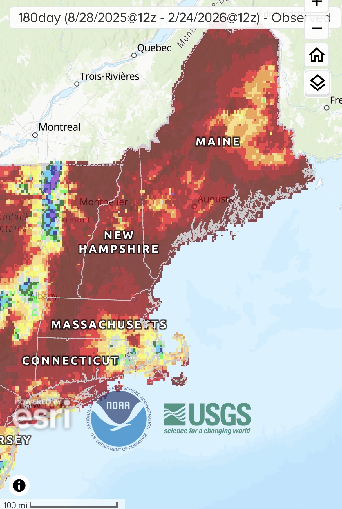
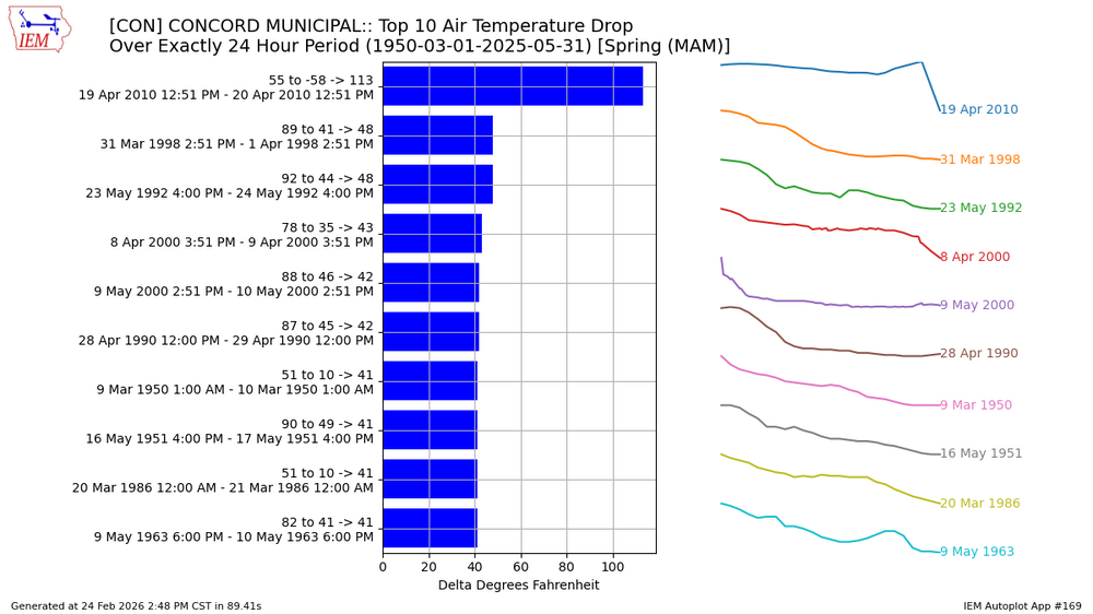
Tied for the largest spring 24hr drop at CON since at least 1950. I don’t recall the May 1992 one but that looks brutal too.
-
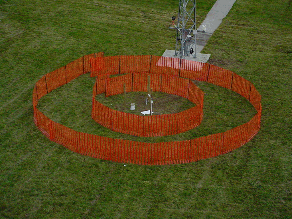
I joked last night, but all of those Fall River roofs were blown almost clean. It has to go somewhere. But yeah…it’s like rainfall totals in a legit hurricane. Good freakin luck. If you really want to get serious and have the space…NWS GRR once experimented with automated snow measuring and put concentric snow fences around it to cut down on drifting. https://www.weather.gov/grr/snowsensor

-
March 98 laughed at pack in NNE.
-
Yup. That’s when you know which observers to hand out the scarlet letter to.
-
"Don’t do it" 2026 Blizzard obs, updates and pictures.
dendrite replied to Ginx snewx's topic in New England
How do you even clear in 40+ mph winds without already fallen snow drifting or blowing back into your cleared area (essentially filling the bowl back in). I think I’d be tempted to measure this at the very end as well. Luckily I rarely get much wind with my snow. -
We should plot the grades on a map at the end of winter
-
A on pack (mostly semi deep since 12/2) B on cold (consistent but nothing high end) C on snow (basically running near avg) D on intangibles (too much nickle and diming…missing the biggies…little rain is a plus B-/C+
-
"Don’t do it" 2026 Blizzard obs, updates and pictures.
dendrite replied to Ginx snewx's topic in New England
Good thing it was Cantore and not Bob Stokes -
Let me out.
-
I’m still hoping Legro can fit freshet into an AFD one of these Marches.