snowstormcanuck
-
Posts
12,356 -
Joined
-
Last visited
Content Type
Profiles
Blogs
Forums
American Weather
Media Demo
Store
Gallery
Everything posted by snowstormcanuck
-

Jan 14-15th Hybrid Winter Storm
snowstormcanuck replied to Chicago Storm's topic in Lakes/Ohio Valley
This sums it up pretty well. And the bold part is a really good point: 99/100 this transfers to the coast and we get our typical 4-8" whatever. Blocky upstream pattern and northern stream diving in quickly acted in tandem to drag everything further west than normal. GFS for the win. Since it underwent that upgrade it's been rock solid. Showed this inland scenario 5 days out when the consensus was coastal. -
Jan 14-15th Hybrid Winter Storm
snowstormcanuck replied to Chicago Storm's topic in Lakes/Ohio Valley
Save this one T.O. peeps. May not ever see it again.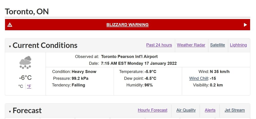
-
Jan 14-15th Hybrid Winter Storm
snowstormcanuck replied to Chicago Storm's topic in Lakes/Ohio Valley
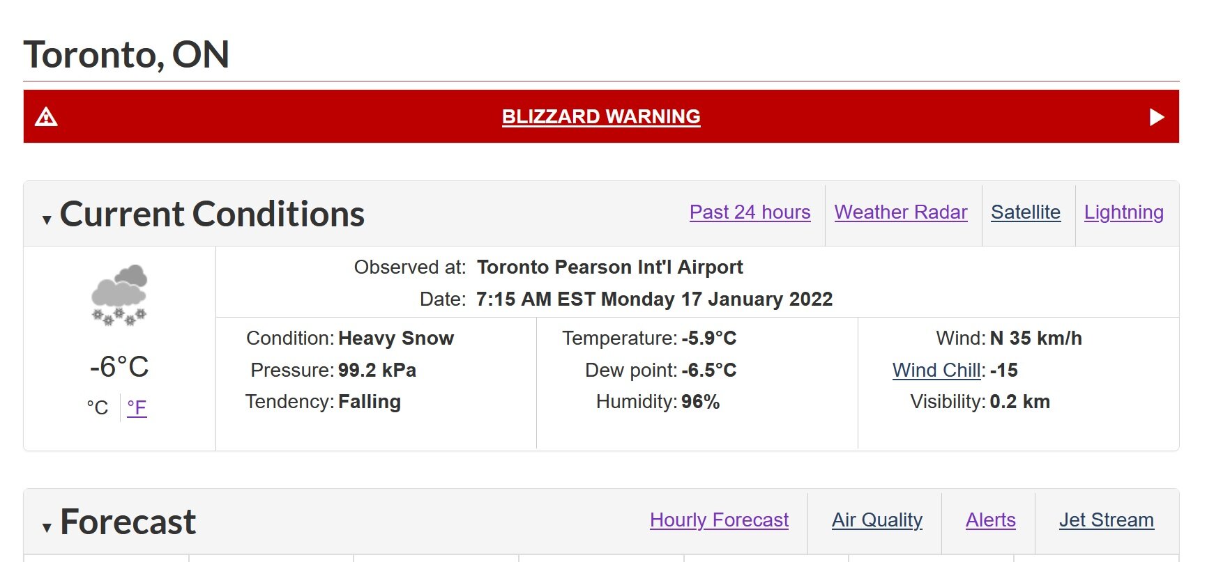
Well that was the peak right there. Nothing left to live for. All downhill from here. That was 3-4"/hr rates around 8am yesterday. Never experienced snow up to my knees. Eyeballing 16-18" range but it's so hard to tell with all the blowing snow. And a Blizzard Warning!! Never did I think I'd see the day. I used to sh*t all over YYZ but reading twitter it's clicking how hard airport snowfall obs must be when there's tons of wind. -
Well, I'm going be official stats. Nov 2020 = 19.4cm or 7.7" at YYZ.
-
Welcome to Toronto! If you love snow, turn around.
-
lol, I know right? We grind like champs here. Except for the big dog on January 28-29, 2019, Toronto has not had an 8"+ snowstorm since the 2014-15 winter. By contrast, we've had 17 snowfalls in the 4-8" range in that same period.
-
Heavier snow rates with this little guy than with the last two "storms." 1.5" between 11-12z and we may duplicate that again this hour. Unfortunately, a quick mover so that'll be all.
-
Looks like 2-4" of plaster tomorrow morning. Pad the stats and looks pretty for about 2 hours before it melts. C'est la vie.
-
Feb 17-19th Potential Of Potential
snowstormcanuck replied to Chicago Storm's topic in Lakes/Ohio Valley
Agreed. Thinking of going from a condo to a house in the next couple of years, and Burlington area is on my radar because of this. -
Feb 17-19th Potential Of Potential
snowstormcanuck replied to Chicago Storm's topic in Lakes/Ohio Valley
Was hoping this would be a northern redux of what happened to Burlington last week but instability was more marginal this time (delta-Ts 12-14?) and the transitory nature of the band didn't help either. Oh well, as you say at least it's a nice wintry feel. Sunday night we add a few more inches for peak winter and then we begin the slow ascent into spring! -
Feb 17-19th Potential Of Potential
snowstormcanuck replied to Chicago Storm's topic in Lakes/Ohio Valley
lol, thanks. Per Twitter, 3-4" seems to rule the realm. Haven't seen anything higher than that so far. -
Feb 17-19th Potential Of Potential
snowstormcanuck replied to Chicago Storm's topic in Lakes/Ohio Valley
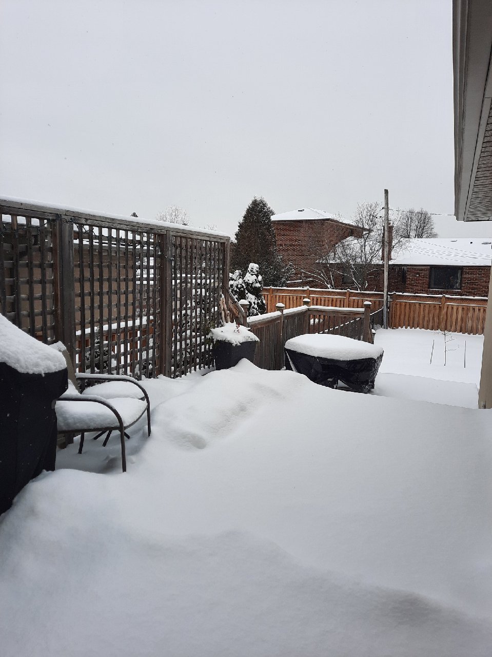
Thinking 7-8. Here's a crappy shot from the breakfast table:
-
Feb 17-19th Potential Of Potential
snowstormcanuck replied to Chicago Storm's topic in Lakes/Ohio Valley
Looks like it wiggled around too much for anyone to get smoked. YYZ up to 3.2". 3.5" call looks like money. -
Feb 17-19th Potential Of Potential
snowstormcanuck replied to Chicago Storm's topic in Lakes/Ohio Valley
Picked up under 1.5" as the lake band lifted north. Got into OB's backyard after all . Too transient to produce any heavy damage but HRRR/RUC indicate it may reorganize this evening. -
Feb 17-19th Potential Of Potential
snowstormcanuck replied to Chicago Storm's topic in Lakes/Ohio Valley
Saw some early signs that the band was trying to form on BUF radar but it's since fizzled. This was well ahead of schedule though anyway; once better moisture arrives and shear is reduced it should get going by early p.m. -
Feb 17-19th Potential Of Potential
snowstormcanuck replied to Chicago Storm's topic in Lakes/Ohio Valley
I think the synoptic will be able to deliver that. You're not out of the conversation with the LES either but it's not likely to get that far north. -
Feb 17-19th Potential Of Potential
snowstormcanuck replied to Chicago Storm's topic in Lakes/Ohio Valley
Yep, not captured at all by the models. -
Feb 17-19th Potential Of Potential
snowstormcanuck replied to Chicago Storm's topic in Lakes/Ohio Valley
Thinking back to that "event" in mid-December when all the models were gung-ho on a major east wind LES event and nothing materialized. If you do this for a living, I don't envy you. At least this is more of a seeder-feeder/LEnhS event so I think it's more a question of where and not if. -
Feb 17-19th Potential Of Potential
snowstormcanuck replied to Chicago Storm's topic in Lakes/Ohio Valley
21z RAP actually looks a bit north of the RGEM, focusing 401 corridor and upslope areas along the escarpment. A few degrees in wind direction, sfc, 925 and 850 are going to make a huge difference. -
Feb 17-19th Potential Of Potential
snowstormcanuck replied to Chicago Storm's topic in Lakes/Ohio Valley
Well the synoptic will probably drop a couple of inches at the very least but I get the point: we could whiff entirely on the LES. Going 3.5" at YYZ with high uncertainty. -
Feb 17-19th Potential Of Potential
snowstormcanuck replied to Chicago Storm's topic in Lakes/Ohio Valley
Snow squall watch for Toronto, Southern Peel, and Halton. EC hitting Peel and Halton harder with amounts which i believe is correct. Should be fun to watch unfold. -
Feb 17-19th Potential Of Potential
snowstormcanuck replied to Chicago Storm's topic in Lakes/Ohio Valley
Interesting to see the trend of having the band impact the City. Sfc low well to the south so normally this would back the winds enough to keep everywhere east of Oakville out of the game. This band might be rooted further up in the atmosphere were winds are more ELY? -
That's incredible for a non-belt location, and you may not be finished. Trying to think if I've ever had 33"+ in 18 days...nothing in recent history, not even Feb 2008. Jan '99 yes, but that's so long ago it might as well been a different life.
-
Surpassed 40" for the season with today's snowfall at YYZ; 4th winter in a row and quite the feat considering it's been nearly 40 years since that's happened. Got me thinking about the banality of these winters notwithstanding that feat. Really, just nickels and dimes since 2016, a couple of moderate events, and just the one big dog in Jan 2019. Aside from the 13.1" in Jan '19, I don't think there's even been another 8"+ snowfall, let alone 12"+, over that period of time. Maybe someone can correct me if I've missed a storm. Not even sure what my point is. Just some mid-evening ramblings.
-
I don't think there's a word in the English language to describe what I feel looking at this..."jealous" would be the closest approximation.