Terpeast
-
Posts
6,687 -
Joined
-
Last visited
Content Type
Profiles
Blogs
Forums
American Weather
Media Demo
Store
Gallery
Everything posted by Terpeast
-
About time. We could never get a +pna wave to stick long enough for even one legit threat. Now, this bodes well for next season.
-
0.9” ashburn
-
2023 Mid-Atlantic Severe Wx Thread (General Discussion)
Terpeast replied to Kmlwx's topic in Mid Atlantic
Gusty and pouring. Think I got 2 cells to train right over me -
Anyone hit 90 for the high today? Got up to 89 in ashburn
-
Makes sense. The record strength -pdo will surely put the brakes on nino development that puts a super event at an almost zero chance of happening. If we want a snowy winter, we better hope that the developing nino gets strong enough to pull the pdo towards neutral-ish so that the mid-lat atmosphere begins to couple with the nino before winter starts. Moderate will do it. Weak won’t cut it.
-
Got a frosty car-topper. Did I plant my new garden too early?
-
Got almost nothing here in Ashburn. Ridiculous
-
We could use the rain. About to start a vegetable garden. Ground is dusty bone dry
-
It’s nice out, but the pollen has been killing me
-
Hit 88 for the high today. Ashburn
-
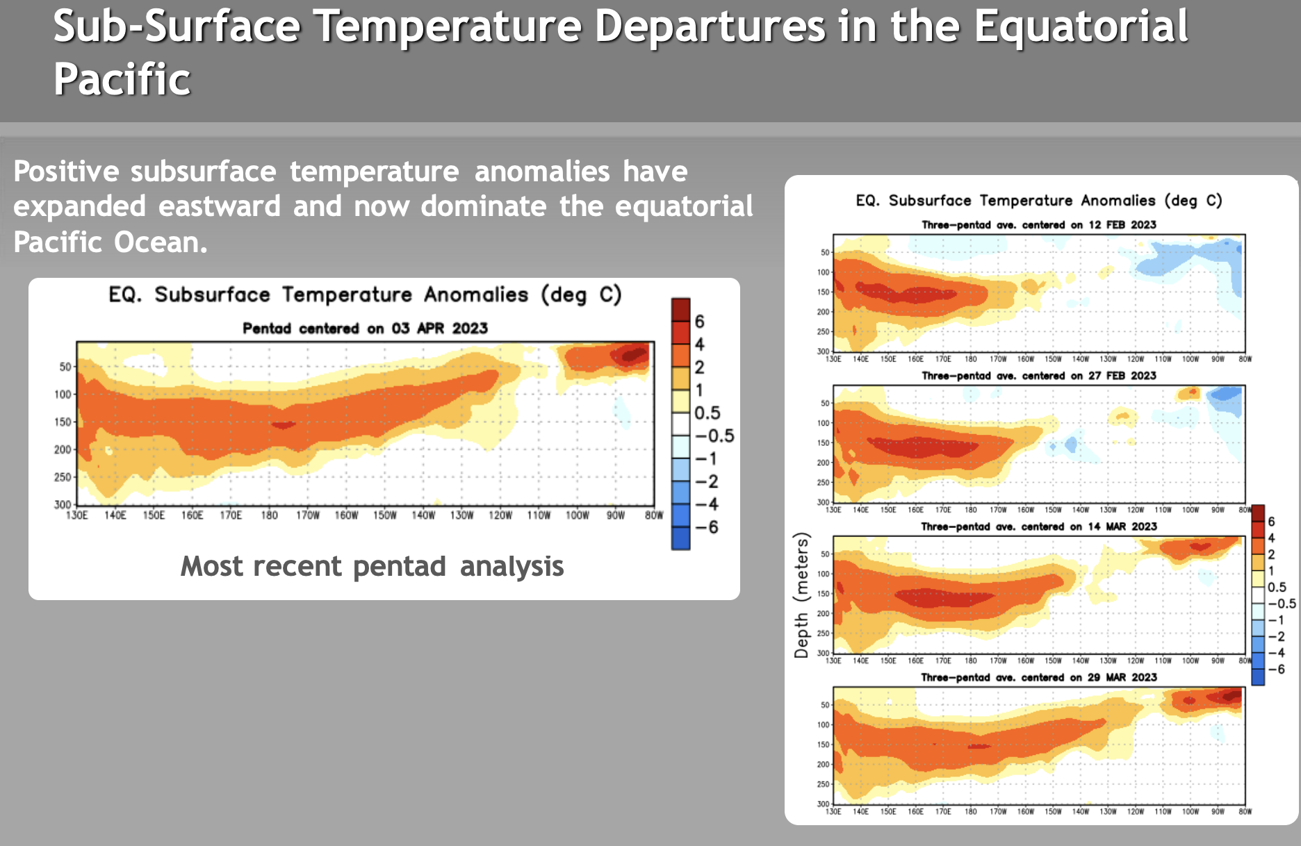
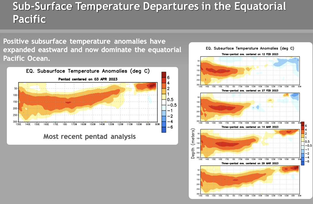
Looks like subsurface has been cooling over the past few weeks. +4 maybe +5 now down to a max of +4 at 175W centered on April 3. Yours is more up to date, and you have it down to +3.25. And it also looks more west-based this time than previous super ninos, at least under the surface. We'll see how that propagates...
-
Were we forecasted to hit 80 today? This morning I was expecting to wake up to a low in the 40s, but it was 61 at 7 am!
-
So you're thinking that after this winter, we'll see more of an east-based -NAO with a trough over central Canada/CONUS?
-
@psuhoffman yes, that makes a lot of sense. Warmer ssts with more moisture makes it easier for waves to amplify earlier and faster as they eject from the rockies. Hopefully flipping to a nino will help cool those gulf temps down. But that may take a while. Ninos tend to suppress hurricane activity, so the gulf may get even hotter before it cools down.
-
More frost than yesterday, but car thermometer said 36. Maybe bottomed out at 33-34
-
Which makes it even more mind boggling. We can somewhat understand this season because Jan-Feb was a +8 torch through and through, and us not producing for the 2 blocking episodes was bad luck. But 72-73 was wet with near normal temps. It probably should have been a decent or even a big winter since it was not that warm then. Bad luck as much as the +nao.
-
About as often as it did this year. But even then, we used to cash in on smaller 1-3/2-4” events in setups like these.
-
Yeah, just eyeballing daily h/l temps it certainly seemed to follow a warm/wet cold/dry pattern
-
Two great winters for the MA, and one ratter. Could go either way, but I checked IAD temps for DJF 72-73 expecting a torch, but found near normal temps throughout. Deep south got 1 great snowstorm at least. Could have been atrociously bad luck for the MA?
-
you should probably change your name...
-
0.33 today. Hope we get a break from the pollen for a week or so.
-
84 in ashburn
-
87 for the high. Was digging to prep a new garden…. Sweating like it was June
-
If anything, it looks even worse than this winter pattern-wise. 72-73 has +ao/+nao, while we had strong -nao twice, neither of which produced for the MA
-
At least we see warm sst anomalies hugging the US W coast on cfs. Not a bad look at all… just closer to our ideal setup than we’ve had all year.