

Terpeast
-
Posts
6,644 -
Joined
-
Last visited
Content Type
Profiles
Blogs
Forums
American Weather
Media Demo
Store
Gallery
Everything posted by Terpeast
-
Oh, there will be. Maybe as soon as the end of this year?
- 2,509 replies
-
- 1
-

-
- weenie fest or weenie roast?
- weenies got roasted
- (and 2 more)
-
The Weekend Rule? Saturday 2/17 - The Icon Storm
Terpeast replied to DDweatherman's topic in Mid Atlantic
Would be great to get a slight south trend with colder air so we get the secondary precip max across the DC/Balt metros. Given the makeup of this winter, that certainly isn't out of the question. -
The Weekend Rule? Saturday 2/17 - The Icon Storm
Terpeast replied to DDweatherman's topic in Mid Atlantic
Looks like a dragon's claw -
Looks like a La Nina March. Maybe that'll give us a chance to move on early. I've got a trip out of the country in April so I can happily skip the cold rain, and be back in time for severe weather season.
- 2,509 replies
-
- 1
-
-
- weenie fest or weenie roast?
- weenies got roasted
- (and 2 more)
-
The Weekend Rule? Saturday 2/17 - The Icon Storm
Terpeast replied to DDweatherman's topic in Mid Atlantic
NAM trended not only warmer, but also faster the past 4 runs. We'll want it to slow down a bit to get it timed better with colder air. But with things being so progressive... (I'll let you finish that thought yourselves) -
I'd phrase this question differently. If this storm had been a powerful cutter like the 2 we saw in January before the two snows, it might have led to a stronger NAO block. Still doesn't mean we'd get a HECS out of it, though.. because who knows how long that NAO would have lasted anyway. We'll never really know
- 2,509 replies
-
- 4
-
-
- weenie fest or weenie roast?
- weenies got roasted
- (and 2 more)
-
I have a good feeling that this will be papered to death by climate scientists around the world.
- 2,509 replies
-
- 3
-
-
- weenie fest or weenie roast?
- weenies got roasted
- (and 2 more)
-
Even if this La Nina stays weak-moderate, the surrounding warmth of the oceans and the West Pac will create a very strong La Nina state much like 2022-23. With a +QBO and solar cycle beginning to descend, we will likely have less blocking than even 2022-23. With all the cold air bottled up at the pole/Siberia or again dumping to the western NA, I'm thinking AN to much AN temps across the entire CONUS except maybe near normal over the Pac NW. East coast will likely be much AN+++ with 60s being commonplace, with strings of 70 degree days interspersed throughout even the deepest winter months. Warmest winter on record across the east? Even higher chance of that happening than this year and last year.
-
The Weekend Rule? Saturday 2/17 - The Icon Storm
Terpeast replied to DDweatherman's topic in Mid Atlantic
Between the euro and other models that trended souther/drier, I’d call it an overall hold. Still 3 days out -
You had breakfast with DT?
-
The Weekend Rule? Saturday 2/17 - The Icon Storm
Terpeast replied to DDweatherman's topic in Mid Atlantic
Its amazing what 10 days of wintry conditions in January has done -
Looks familiar. Where have I seen this before?
- 2,509 replies
-
- 6
-

-
- weenie fest or weenie roast?
- weenies got roasted
- (and 2 more)
-
The Weekend Rule? Saturday 2/17 - The Icon Storm
Terpeast replied to DDweatherman's topic in Mid Atlantic
Oy.. what have I done? -
The Weekend Rule? Saturday 2/17 - The Icon Storm
Terpeast replied to DDweatherman's topic in Mid Atlantic
I’m starting to prefer that. When we lose school days, the kiddo stays home and the only time she’s in a happy mood is when we’re playing outside in the snow. But if we’re not outside, it’s tantrum galore. Rather send her to preschool and keep the snow on weekends when she’s home anyway. That’ll change when she hits kindergarten or first grade, but for now… yeah. -
The Weekend Rule? Saturday 2/17 - The Icon Storm
Terpeast replied to DDweatherman's topic in Mid Atlantic
If the high end is only 3-4” and we’ve seen last minute shifts of more than 200 miles, then yeah I’d say it does matter I’m not saying cancel. I’m just not getting too invested until 24-48 hours -
The Weekend Rule? Saturday 2/17 - The Icon Storm
Terpeast replied to DDweatherman's topic in Mid Atlantic
Pretty sure the cmc and euro will juice up a bit more as it gets closer in time but the track? TBD, low confidence forecast when two bad models trend in opposite directions then there’s always the last minute shift within 24 hours - personality of the winter a la Bob Chill -
Yes, just probably not this year or next year.
-
Pretty much yea. At least we’ll be expecting that 10 months ahead of time. We’ll live.
-
Both this and last winter we at least had some blocking. Next winter we probably won’t. Not to the extent that we have seen anyway. I’d want to see wholesale changes in the pacific and for the atlantic to cool off to change my outlook. Until then, I’m setting fare alerts on Google flights.
-
The Weekend Rule? Saturday 2/17 - The Icon Storm
Terpeast replied to DDweatherman's topic in Mid Atlantic
I was also half joking, but it's true that the GFS isn't doing much better either. Maybe even worse than the ICON. If the GFS had support from other models, then yeah there's some credibility, but if it's alone it should be tossed. Even if it shows a snowstorm. -
I don't think PSU is depressing himself here. He's looking at the data, being realistic, and trying to give us a dose of realism. I may strike a more optimistic tone than PSU, but I mostly agree with him (like 95%). And although I'm usually an optimist, I'm pretty black-pilled about winter 2024-25.

- 2,509 replies
-
- 8
-
-

-
- weenie fest or weenie roast?
- weenies got roasted
- (and 2 more)
-
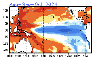
Annual family vacation to guaranteed snowy destinations. That's gonna be the way... Especially next year's Super Nina, +QBO, +AO, descending solar off a maximum, with continued marine heat waves off Japan and the West Pac warm pool. Did you see the CFS sst forecast in the NCEP ENSO update? Winter 2024-25 is going to be historic... and not in the way we want it. Look at this. Horrifying.
-
The Weekend Rule? Saturday 2/17 - The Icon Storm
Terpeast replied to DDweatherman's topic in Mid Atlantic
Too bad it's the ICON -
2024 Valentines Day Who the Hell Knows - Comeback Thread
Terpeast replied to DDweatherman's topic in Mid Atlantic
I was surprised we got ANY snowfall from this. Zero cold air, no NAO, we were coming off a warm pattern, and the "pattern change" was set to start with the passage of this storm. We don't usually get any snow at the beginning of a pattern change, usuaally in the middle or end of it. We wouldn't be having this conversation if this thing tracked north across PA and hit New England with a foot+ of snow. Instead we'd be saying, "ok this is the start of a pattern change, now let's start tracking." We (far N&W favored areas with elevation) got lucky with this one. -
Same, 7A. +6 since 2012. Hard to believe, since I ran the numbers on IAD and it's a more gradual +4 since 1962

