tamarack
-
Posts
16,410 -
Joined
-
Last visited
Content Type
Profiles
Blogs
Forums
American Weather
Media Demo
Store
Gallery
Everything posted by tamarack
-
For most of NNE, Irene is the only impactful TC since Floyd. We got 4" from Irene but little wind, while Floyd dumped nearly 6" and had gusts into the 40s here, our most recent siggy wind from a TC. Our white birch is beginning to shed, as is usual by early August. Can't recall the black birch in NNJ dropping leaves early and we're north of its range here.
-
Absolutely! Rain shadows downwind of the higher volcanic mountains are found on all the major islands. It still amazes that HI has places that get rain similar to that at Phoenix and places (on Kauai) that are in the running for the Earth's wettest climate.
-
I'm a bit suspicious of CON's coldest for 1910-40. They only got down to -19 on 2/9/34, just 1° colder than BOS (their coldest morning), 4° below Central Park (their coldest, too) and 11° milder than EEN. Seems like CON should've been at the colder end of the -20s. Also, my CON records only go back thru 1920, thus missing the frigid Dec 17-Jan 18 week.
-
GYX morning AFD has today's best chance for TS from the Capitol District south, and heaviest RA tomorrow-Tuesday from the mountains north. Guess what lies between. At least the front should be near enough to end the big heat here after today, even while the dews remain swampy for a few more days.
-
Would've loved that "nadir" as it was more than twice what fell here.
-
Nice 1940s baseball lore. But I think those storms will poop out before reaching 70° west longitude (or will stay to our south).
-
Our one HI trip stayed on Oahu, as my BIL lives in Haleiwa. The temp difference between south shore Honolulu and the North Shore was quite a contrast, sunny 80s vs showery low 70s with locals shivering around their electric space heaters. Coming from sleety Maine March, we much preferred the cool.
-
FVE at noon: 74/52. HUL 78/58. O so close.
-
Having framed houses in NNJ during peak HHH, I think they're leading you on, unless they like it because it provides a reason for an afternoon beer break.
-
Listened to thunder from 8 to 10 last evening, some from strikes within 2 miles. 2 hours traumatizing the dog for just 0.08", with another 0.05" some hours later. Crosstown neighbor reported 0.25". Low of 66 this morning under the clouds. Very warm and humid yesterday morning but a cloud deck arrived at noon to hold the max to 85.
-
Maybe mow down the mountains too and move us 500 miles closer to the Gulf of Mexico. Mid 80s by late morning pointed toward 90, but the cloud deck that slid overhead from the north at noon cut the legs off the max. No precip associated with the clouds, unfortunately.
-
Maybe in 2002? We seldom reach even 90 here, only 18 days in 24+ years, but had a 3-day heat wave in August that year. Enjoying the 80° day with mid 50s dews, probably the last of those until perhaps Tuesday.
-
0.03" here, then watched the cell grow up (as usual, once they pass here) and pound the BGR area.
-
Severe Weather Threat Week...so many threats!!!
tamarack replied to weatherwiz's topic in New England
10 minutes of light RA then a couple rumbles as the cell grew up after passing here. -
Most of them. (TMI)
-
Warmest here was 86, twice. Both May (90) and June (89) got warmer. Month summary: Avg temp: 66.2 +0.8 Avg. max: 78.5 +2.2 Highest: 86, 17th and 23rd. The coolest max was 70, on the 6th. This is our first July to have no maxima under 70. Avg. min: 53.8 -0.6 Lowest: 42 on the 10th (Both the max and min are right on the median values, records 1998 on.) Precip: 2.90" -1.01" Wettest day: 0.71" on the 19th. The event total was 1.32", with 0.61" on the 18th. This makes 3 straight BN months and 8 of the last 10 have had BN precip. Thunder: Two days, 14th and 25th. Average for July is 4.4. The earlier TS was warned and produced wind damage in Belgrade.
-
Hope they don't let some would-be contender poach Mancini - very good player, even better story. Wish we could keep today's breezy 70s thru Sept 15 (with some after-dark RA, of course).
-
That's an important point for midsummer averages. My average max for 7/30 here is 77, the warmest for 24 Julys is 85 in both 1999 and 2019, while the coolest max is 62 on a drizzly day in 2014. The average for 2 days at 85 and one at 62 is - 77, oddly enough. That's how summer averages work - majority of days with AN highs but the coolest days are farther from the average.
-
Why not - CAR might've done that in May 1977. The newsies had them tied with Phoenix at 96 on the 22nd, though the latter's AP hit 98 that day. However, on 5/24 Phoenix had a rainy 79 while CAR completed their only May heat wave, reaching 94.
-
We did a little better, 7.87", or 62% of the 12.77" average for MJJ.
-
2.75" across the Androscoggin in Auburn. Meanwhile, 40 miles NNE, New Sharon had 2 of the 4 (out of 100 total) cocorahs observations with no measurable precip. (Other 2 were 80-90 miles east in Hancock County.)
-
Severe Weather Threat Week...so many threats!!!
tamarack replied to weatherwiz's topic in New England
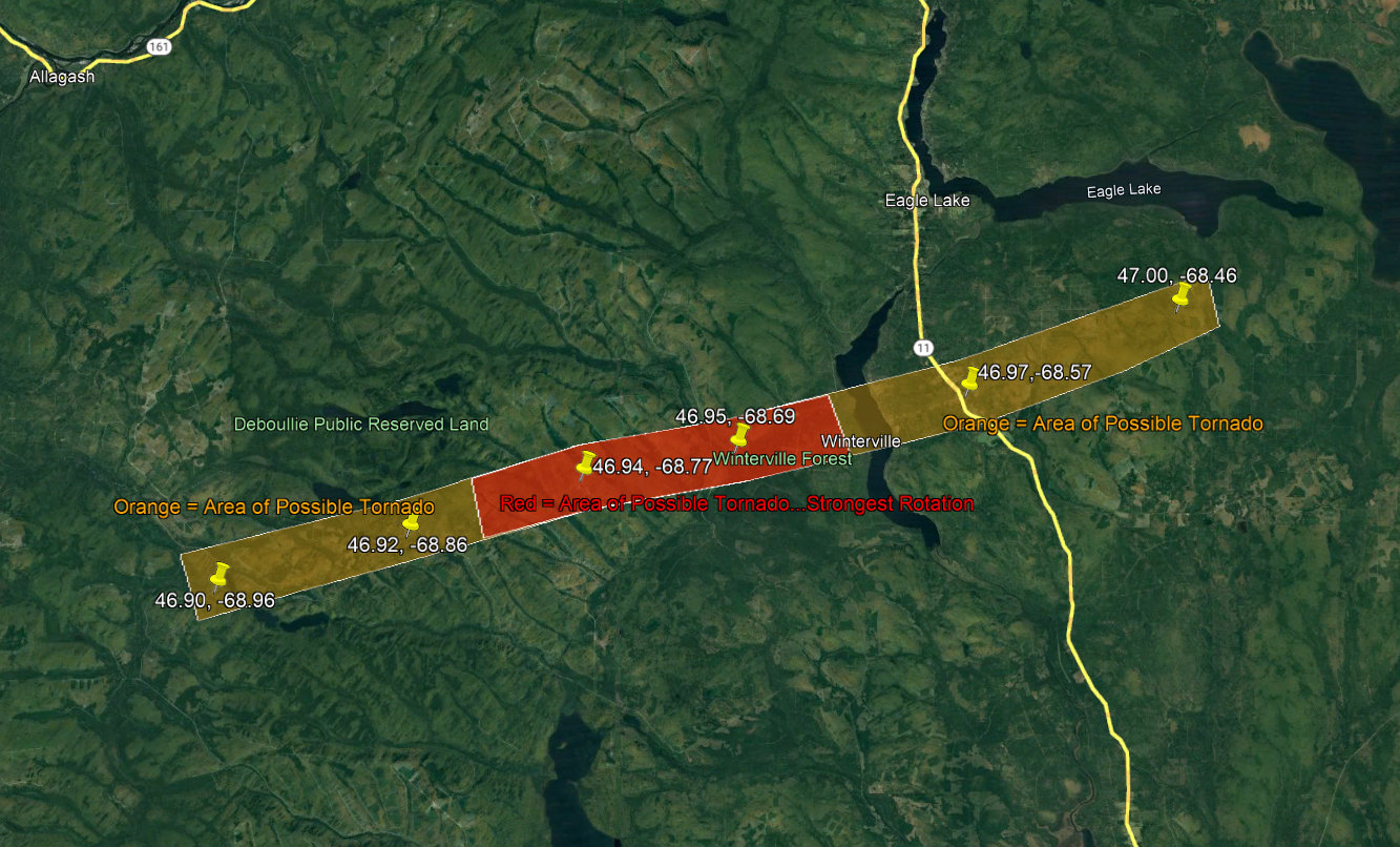
Monday overperformed here, yesterday nasomuch. Maine cocorahs is up to 100 reports so far, and only 4 had no measurable precip. Two were in Hancock County, Downeast, and the other two were in the small town of New Sharon. We did better than our crosstown neighbor however, getting a trace (sprinkles while I was outside grilling dinner) compared to zero. Meanwhile, the Farmington cocorahs observer had 0.44" and farther south in Auburn, 2 observers had over 2.7". Here's the map made by Public Lands staff after flying over the area affected by Monday's storm, the one that had hail of tennis ball size. Fort Kent is about 10 miles north of the upper edge of the pic. The firetower noted earlier is above the "R" of "Reserved". The area north of Eagle Lake (between the town and lake name labels) is where about 200 acres were mostly flattened in 2012 and 2,700 cords salvaged. This is 2020 imagery at Eagle Lake and 8 years has lessened the visual impact. (The odd color between Eagle and Square Lakes is open bog.)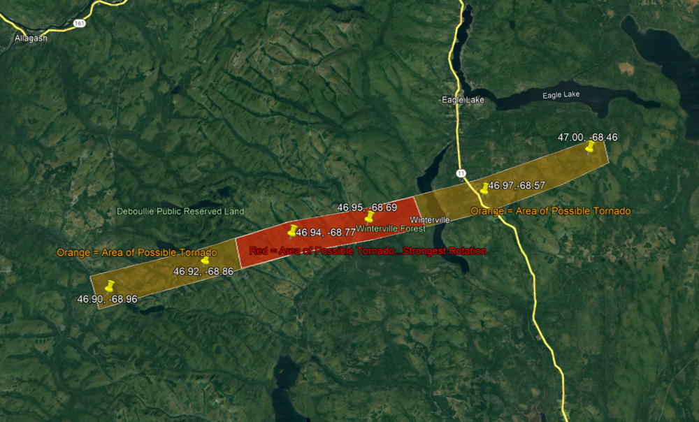
-
Early spring can be awful, but late spring often has the nicest wx of the year, a time when 65/30 feels summery and green things begin to appear. (And my season sequence is the same as yours.)
-
Getting 2" over the past 10 days has brought the month to 2.90". July average is 4.06" so we'll need a lot more than the forecast (1/4-1/2") to avoid the 8th BN month in the last 10. (And the 2 AN months, Feb/April, were only 0.62" and 0.77" above the mean.)
-
Severe Weather Threat Week...so many threats!!!
tamarack replied to weatherwiz's topic in New England
IMO, that's a generous estimate, at least for here. Perhaps divide it by 10, maybe 20, for MBY. I think we've been in the box 4 times this year and might make it 5 today, and that's about the average. In 24+ years we're yet to experience severe conditions - closest was June 2005 and the 14th last month. It's been close, the hailstorm that defoliated (and partially debarked) trees on several thousand acres in late August 2007 was less than 10 miles away. Every 2-3 years we get inside a warning area, even a tornado warning once - that system washed out some roads in the next town west (we got 0.09" and no thunder) and dropped an EF-1 about 30 miles to our east.