

hazwoper
-
Posts
3,489 -
Joined
-
Last visited
Content Type
Profiles
Blogs
Forums
American Weather
Media Demo
Store
Gallery
Everything posted by hazwoper
-
So, looks like PHL will keep the record going and doesn't look to be touched in the foreseeable future.
-
That output looks reasonable, with perhaps a quicker drop off at the fall line especially due to ocean temps.
-
Marginal airmass and 47 degree ocean temps. I'll be happy with 2-3".
-
Yeah, I'd probably go 176 for the QSTs. Thinking of maybe just dumping my Declivity's and just using the QSTs for my all around ski......decisions decisions.
-
Looking to get a second set to add to quiver. I am between a Elan Rip Stick 96 172cm and a Salomon QST92 168cm I am 5'11 215 lbs. I already have an Armada Declivity 82ti 182cm. I am looking for a ski to make it easier for me to enjoy the glades with my sons and as my go to for our first trip out west . Obviously I'll mostly be skiing on the NE (PA/NY/VT). Thoughts on these two or potentially others for me? I'd say I am an advanced skier that doesn't look to do anything crazy.
-
 It’s nasty here in Brigantine
 -
Cat 4 now
-
Cantore there as well.
-
With a strengthening major hurricane making landfall, yeah he needs to get out while he can.
-
I really hope no one stayed in Steinhatchee, but I am afraid some most certainly have.
-
Now forecast to be cat 4 at landfall 130mph
-
I don’t know. I’m not seeing it yet. Eye still seems to be coalescing and this is still only 110mph storm. ERc doesn’t typically happen till storms are stronger. Time will tell I suppose
-
Anyone know who is chasing and likely doing a live feed later? Any links?
-
Bump LOL
-
E PA/NJ/DE Spring 2023 OBS Thread
hazwoper replied to Hurricane Agnes's topic in Philadelphia Region
Confirmed tornado right down the road. My son was out chasing when it dropped down at his location. Like father like son.... -
E PA/NJ/DE Spring 2023 OBS Thread
hazwoper replied to Hurricane Agnes's topic in Philadelphia Region
I was wrong. We topped out at 61 at 10:35 PM. -
E PA/NJ/DE Spring 2023 OBS Thread
hazwoper replied to Hurricane Agnes's topic in Philadelphia Region
Topped out at 59.9 here at 6:10 -
E PA/NJ/DE Spring 2023 OBS Thread
hazwoper replied to Hurricane Agnes's topic in Philadelphia Region
59.2 here now -
E PA/NJ/DE Spring 2023 OBS Thread
hazwoper replied to Hurricane Agnes's topic in Philadelphia Region
-
E PA/NJ/DE Spring 2023 OBS Thread
hazwoper replied to Hurricane Agnes's topic in Philadelphia Region
Warm front (if you can call it that) is to your west. Temps in LanCo are approaching 60 now. Warmest temps in our area will likely be late this afternoon/early evening when front moves by. -
E PA/NJ/DE Spring 2023 OBS Thread
hazwoper replied to Hurricane Agnes's topic in Philadelphia Region
I can't go down this path with you, I just cant. If you don't realize that humans, through the release of carbon that has been trapped in the earths crust for millions of years is causing the extreme increases in the past century in global temps, then I don't know what to say. Not sure where you got that graph, but this one is far more realistic. Using a 10 degree spread is a bit misleading, to say the least.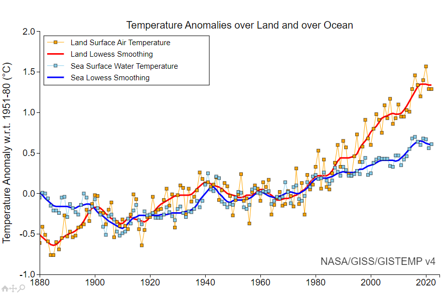
-
E PA/NJ/DE Spring 2023 OBS Thread
hazwoper replied to Hurricane Agnes's topic in Philadelphia Region
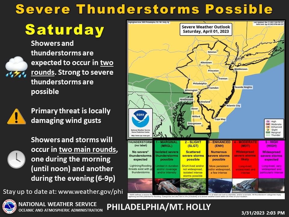
will this one work?
-
E PA/NJ/DE Spring 2023 OBS Thread
hazwoper replied to Hurricane Agnes's topic in Philadelphia Region
Accumulating here. Nice dusting at present with more coming Temp dropped from 33.3 to 31.6 in 30 mins -
E PA/NJ/DE Spring 2023 OBS Thread
hazwoper replied to Hurricane Agnes's topic in Philadelphia Region
Snowing really well at present. Reports of accumulating snow just to my NW with echos from that inbound. -
E PA/NJ/DE Winter 2022-2023 OBS Thread
hazwoper replied to Ralph Wiggum's topic in Philadelphia Region
just over an inch feel here in Wrightstown, PA.


