HKY_WX
-
Posts
3,246 -
Joined
-
Last visited
2 Followers


About HKY_WX

- Birthday 12/13/1984
Recent Profile Visitors
7,929 profile views


-
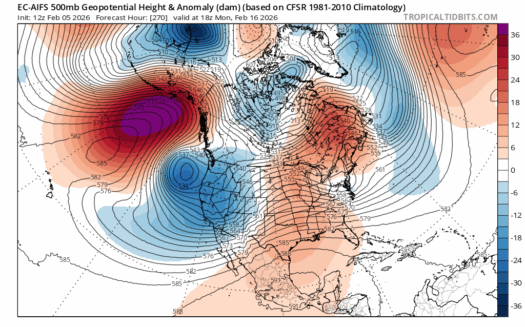
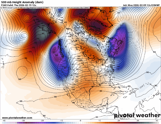
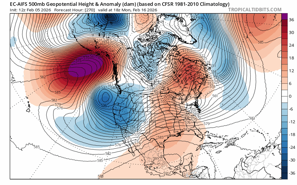
This is a pretty insane -NAO signal day 10. This would displace the mean pattern further south eventually. You would think it could lend itself to one of those classic late winter UL bowling ball snowstorms at some point in late February/March if we're lucky.
-
12 here this Morning and my backyard is still snow covered for the 15th day in a row. Seems like just another day this winter. Pretty wild.
-
The models giveth and the models taketh away... I think there could still be some hope for the last week of February into March. Still early to be calling Winter at this point. That said, I'm going to enjoy the thaw. It's been a fun few months of Winter but my body needs a break. Also i'm tired of trying to entertain a 5 year old indoors.
-
Kinda graupel like
-
Snowing here west of Franklinton
-
AI Euro is showing what i was referring to. Roll over ridges out west normally teleconnect to an eastern US trough. The models this far out are normally pretty worthless, so take with caution.
-
It wasn't that bad up here in central Franklin. We had an 1" back in December, 1.5" sleet, and then 5 inches last weekend. So i guess a total of around 7". Better than the last few winters. We definitely missed out on 2 historic opportunities though. Could have been much better, which is what leaves a bit of a bitter taste on this winter thus far. That said, we still have about 5 (maybe 6) weeks left where we can realistically get something, but the extended modes aren't overly exciting at this point. They have overpredicted the collapse of the -NAO/AO all year though, so I haven't completely given up hope.
-
There are some hints of a roll-over ridge and a return of the +PNA towards the last week of February. Don't see much in the way of winter related action prior to that. Enjoy the thaw next week for now.
-

January 30th- Feb 1st ULL and coastal storm obs
HKY_WX replied to JoshM's topic in Southeastern States
Ended up with 5" here in Franklinton. All fell in a 5 hour period last night. Wild system. Up there with March 1980 for sure. That was probably the best analog 500mb wise, along with Christmas 2010. I feel like my totals did very well outside of Fayetteville. -
January 30th- Feb 1st ULL and coastal storm obs
HKY_WX replied to JoshM's topic in Southeastern States
3.25 here in Franklinton -
January 30th- Feb 1st ULL and coastal storm obs
HKY_WX replied to JoshM's topic in Southeastern States
To my RDU peeps
-
January 30th- Feb 1st ULL and coastal storm obs
HKY_WX replied to JoshM's topic in Southeastern States
We're at 1.5" per hour in these bands around north wake/Franklin county. Recorded that between 7 and 8pm -
January 30th- Feb 1st ULL and coastal storm obs
HKY_WX replied to JoshM's topic in Southeastern States
1.25 in franklintom since 7pm -
January 30th- Feb 1st ULL and coastal storm obs
HKY_WX replied to JoshM's topic in Southeastern States
Heavy snow here in Franlinton. Already have 3/4" in 30 mins. The mega dry air penis has went flacid here in Franklin county -
January 30th- Feb 1st ULL and coastal storm obs
HKY_WX replied to JoshM's topic in Southeastern States
Light snow now here in Franklinton