
dmcginvt
-
Posts
470 -
Joined
-
Last visited
Content Type
Profiles
Blogs
Forums
American Weather
Media Demo
Store
Gallery
Posts posted by dmcginvt
-
-
2 minutes ago, STILL N OF PIKE said:
From 250 am Box Disco
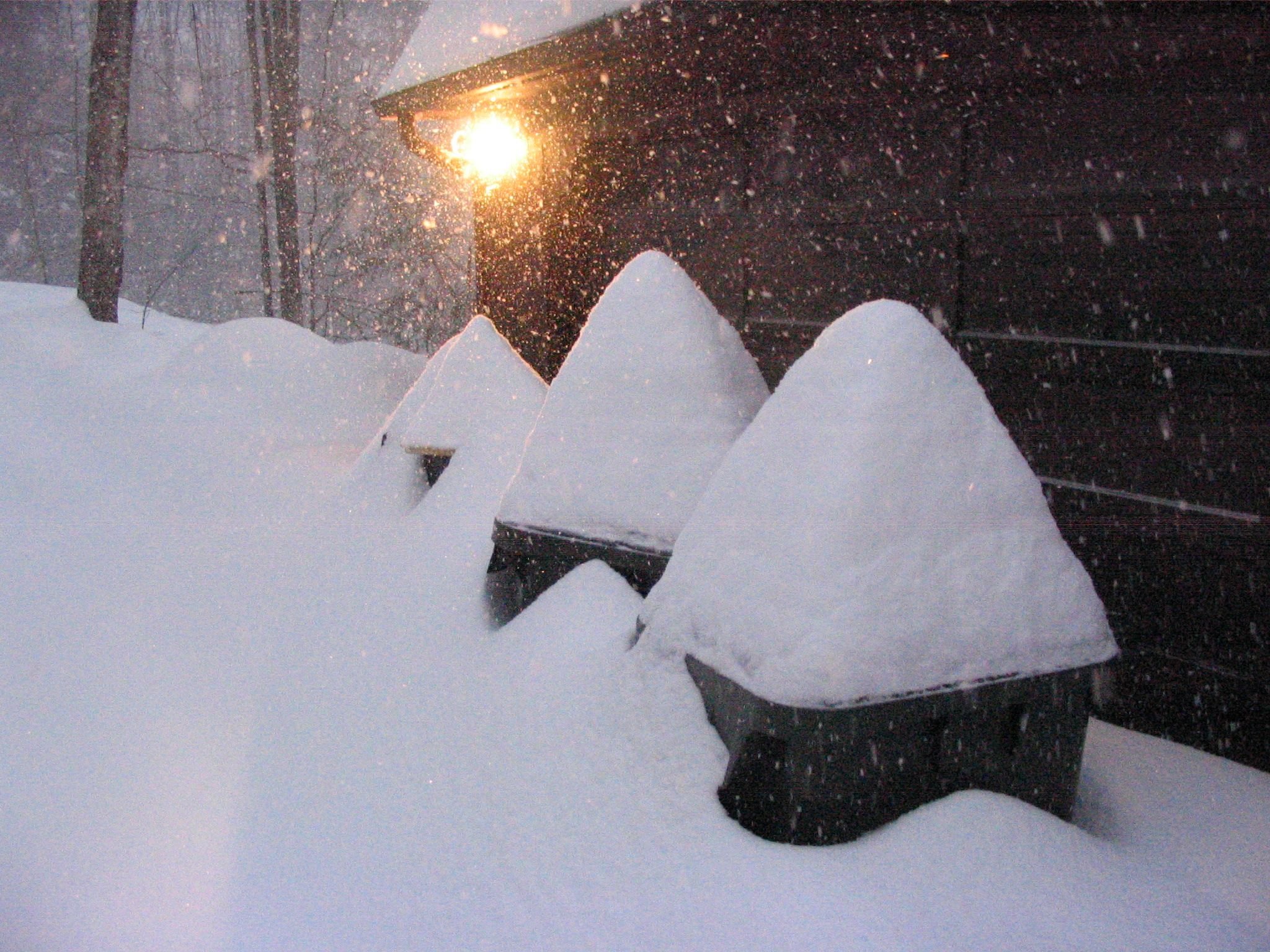
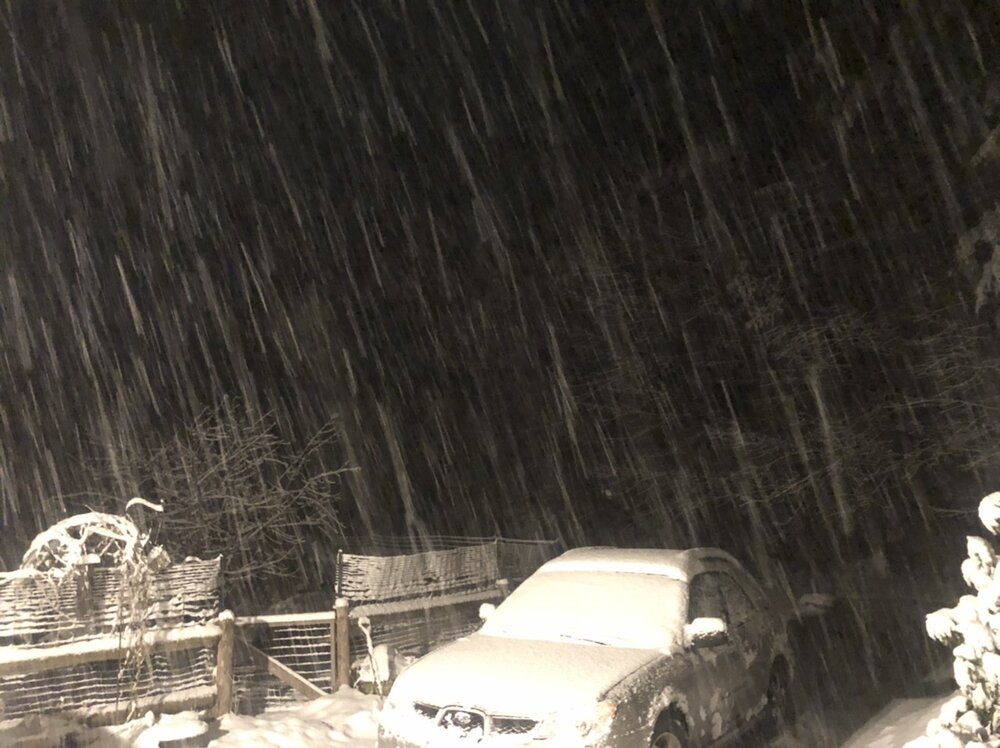
 The trend may
be for total snow accumulations closer to the lower end of the
ranges for most. The higher terrain towards the NH/VT border remains
the most likely locations to see the greatest snow
accumulations.
Not sure what happened but the MD was right. It just started dumping here and I went from 1/4 in to 3" in an hour. we must be under optimal dgz because these flakes are silly. thick and heavy and coming down like a thunderstorm. No thundersnow though.
-
Its dumping so hard now. Literaly pouring snow. Took the dog for a walk and after 20 minutes we were covered by a half inch. Vis is near zero, 100 yards and I couldnt see my house
https://share.icloud.com/photos/002do0rPLhp-r63_8YYHZ8_rw I couldnt embed this
 Im new to iphone
-
 1
1
-
-
16 minutes ago, The 4 Seasons said:
Is that on desktop or mobile? I gotta say their mobile app is probably the worst app in existence. Their support number on it is so old that it takes you to a scam hotline
I dont use it on mobile, desktop only, I paid for weather weather omega after reading reviews for the app and it has no radar tilts for winter mask, WTF? I live in the shadow of the green mountains from our main radar. I need all the tilts always. I asked them and they said
At this time we don't have additional tilts for Winter Weather Radar, however, I see why this would be a priority in your case. This likely won't be something I can get changed right away, as there are a lot of complications with WWR and how it's created, but I'll bring this up to everyone today and see if this is something we can get worked on.Nice and honest answer from a met on their team!But weathertap it is. -
The low is where the hrr shows it. It shows it doing exactly what is expected a few hours of destruction
There will be an MD for this
-
That show me that Ray has a really nice snow coming his way that dark band is coming right for you and hitting worcester now
-
I actually enjoy how weathertap has changed they have added some nice features.

-
1 minute ago, 40/70 Benchmark said:
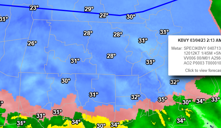
Problem is I have already reached wet bulb...big difference between that and being 33/12.
Well the air changes as the wind blows doesnt it
-
12 minutes ago, 40/70 Benchmark said:
Yea, one would think...gonna need to because my low levels stayed a a bit warmer than I had hoped.
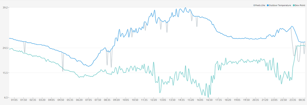
I was shocked by being 33 watching virga with 12 dewpoint and dropping so rapidly to 26/24 in 30 minutes as the front got closer. But again there's going to be a transition between these lows and I have no idea who that will affect both the front giving me the goods and what will happen there, the 995 low in va is fucking with me because it looks like its off the coast of jersey
-
9 minutes ago, dmcginvt said:
Just not your winter my man. I know you like to be in the best parts and who doesnt. But surely your close enough to get enhanced rates...just maybe not the 2 inches per hour?
Also theoretically the low is moving east and presumably reforming off the coast of LI, and you are still north of it so this front will surely push your way NE of the low. Which may mean an MD is coming your way in a few hours. Your getting your snow tonight. I bet we end up being very similar in totals which is frankly quite rare, it's usually you or me.
-
Just not your winter my man. I know you like to be in the best parts and who doesnt. But surely your close enough to get enhanced rates...just maybe not the 2 inches per hour?
-
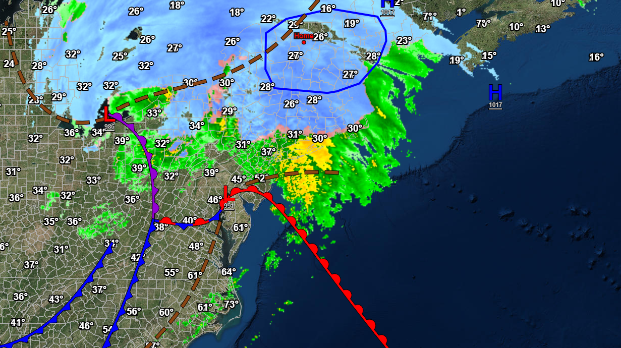
1 hour ago, Ginx snewx said:
Interesting

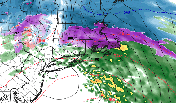
showing some frontogenesis there along the cold front?
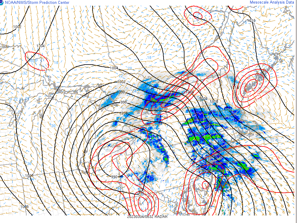
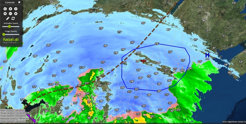
That encircled blue area just had a mesoscale discussion released, and as the radar shows it did just stop snowing here...
 Mesoscale Discussion 0254
   NWS Storm Prediction Center Norman OK
   1240 AM CST Sat Mar 04 2023

   Areas affected...portions of northeast NY into VT/NH and western ME

   Concerning...Heavy snow

   Valid 040640Z - 041245Z

   SUMMARY...Heavy snow with rates of 1 to 2 inches per hour is
   expected across parts of northeast New York, into New Hampshire,
   Vermont, and western Maine through around 12z/7am EST.

   DISCUSSION...Areas of light to moderate snow are ongoing across
   portions of the New England. A heavier band of precipitation over
   eastern NY into MA and southern VT/NH will lift north/northeast and
   intensify overnight. This activity is occurring within a band of
   strong 700 mb frontogenesis and midlevel warm advection, ahead of a
   compact upper trough and surface cyclone. Forecast RAP soundings
   show thermodynamic profiles becoming saturated, with an
   approximately 2.5 kft deep dendritic growth zone. Strong ascent
   through the DGZ and the saturated thermodynamic profile will support
   increasing snowfall rates, with periods of 1 to 2 inch per hour
   rates expected. The highest snowfall rates appear most likely in the
   08-12z time frame.
-
wow, way to saturate that column, KMVL
-
9 minutes ago, HIPPYVALLEY said:
Never noticed your profile pic 2 of my favorite things, Snoopy and the Dead.
") Please stay up all night and keep posting the same pic so we can see the progress!
Please stay up all night and keep posting the same pic so we can see the progress!
-
1
-
-
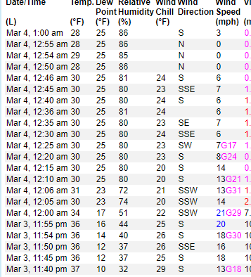
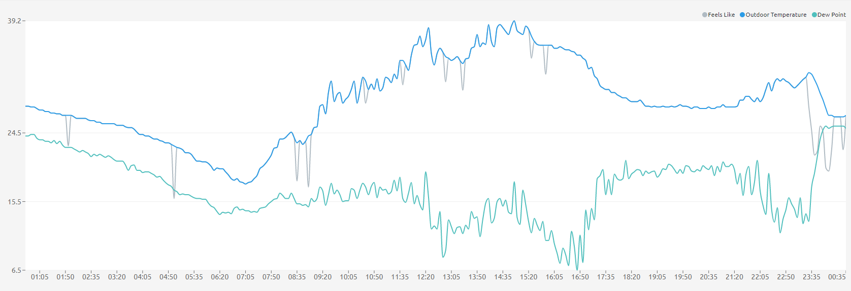
Temp dropped from 33 to 26 and dewpoint went from 12 to 25 in 20 minutes, bam it's snowing. Was also wild to watch the winds which were out of the north and west go 100 % from the SE/East with gusts to 20. 1/4 in in the first hour
-
On 3/1/2023 at 9:53 PM, powderfreak said:
That is absolutely bonkers. I’d start to be worried about getting buried if one of those snow walls calved off. Walk one at a time to make sure if someone gets buried another person is able to get them out, ha. Children can’t go outside either, going to drown.
only word for this is gobsmacked, whats happend in cali this year is just unreal. To the point that it brought tornado chasers to make videos of it, I love that.
-
can i embed this???
-
-
Its cold windy and literally dumping out there right now.
-
Now snowing for real in N VT
-
I just saw 3 flakes
-
 1
1
-
-
Heavy band and still not snow reaching me
-
22.5
dp 16
no snow
-
also this air is so dry it's been snowing over my head for 2 hours
-
My question is did SSW have to do with this? The science doesnt seem strong yet it seems like it's happening. Seems like it was maybe , maybe ,maybe and now yes?. So is it?


March 4 2023 Storm Obs
in New England
Posted
26.1/25.6 Snow started at midnight. 1/4 in first hour. 3.75 since. 4 inches at 4:45am. Wiped board