psuhoffman
-
Posts
27,413 -
Joined
-
Last visited
Content Type
Profiles
Blogs
Forums
American Weather
Media Demo
Store
Gallery
Everything posted by psuhoffman
-
Before things get crazy with the 0z runs... the long range GEFS from last night really reloads a great looking -AO/NAO pattern in January. It's workable to favorable straight through actually.
-
Sorry I posted this in the wrong thread a min ago @dtk @WxUSAF @high risk do you know what resolution the GEFS and EPS members are run at compared to the operational? I have noticed that the ensemble members (of both the EPS and GEFS) have been running warmer even with similar or further east tracks then the operational runs. This has been a consistent correlation for several runs across both ensemble suits. The track of the operationals has changed but the presentation of the thermal structure of the storm has remained fairly consistent...meaning where you expect the thermal boundaries to be wrt to mslp is roughly the same places each run dependent on the MSLP. But those same thermal boundaries seem to be further NW given the same MSLP track on the individual ensemble members of both the EPS and GEFS. I am wondering if they are run at a lower resolution...they may be warmer due to not modeling the meso scale features as well. That may not be correct...just grasping at possible causality for the observation I noted. I know back in the day the NAM would pick up on CAD better due to its higher resolution...one of the few things it was good for at range with a winter synoptic event. You had to adjust for its over amplified bias...but you could get an idea what the thermal structure of the storm might look like.
-

Central PA - Winter 2020/2021
psuhoffman replied to MAG5035's topic in Upstate New York/Pennsylvania
@MAG5035 do you know what resolution the GEFS and EPS members are run at compared to the operational? I have noticed that the ensemble members (of both the EPS and GEFS) are often warmer even with similar or further east tracks then the operational runs. This has been a consistent correlation for several runs across both ensemble suits. The track of the operationals has changed but the presentation of the thermal structure of the storm has remained fairly consistent...meaning where you expect the thermal boundaries to be wrt to mslp. But that seems to be different on the ensembles. I am wondering if they are run at a lower resolution...they may be warmer due to not modeling the meso scale features as well. That may not be correct...just grasping at possible causality for the observation I noted. ETA: I know back in the day the NAM would pick up on CAD better due to its higher resolution...one of the few things it was good for at range with a winter synoptic event. You had to adjust for its over amplified bias...but you could get an idea what the thermal structure of the storm would look like. -
Before the 0z starts..fwiw I think the 18z rgem looked great at 84 hours. High stronger and further SW then most other guidance. Faster wave. It looked like it was about to get good.
-
March 18 clipped his area pretty good
-
best run yet wrt mslp track 18z v 12z
-
Was comparing these wrt the colder profile on top of the primary in KY. Thermals did retreat SLIGHTLY in VA too.
-
I wasn’t picking on you. That was totally ok. Not your fault. That map did say what you said. Those multi plot precip type charts aren’t as precise with estimating pressure locations as the mslp plots.
-
Lol. Not your fault but that map has the high from the 12z run in the wrong spot. I think because the map cuts off just below the true center of the high. Here.. like I said maybe a few miles apart...

-
@WxUSAF one other minor different wrt 18z euro. The thermal boundary shifted north ever so slightly in southern VA by like 10-15 miles but the cold is still draining increasing the gradient so the entire profile didn’t retreat just along the edge. However, it’s colder west of the apps in KY on top of the primary. I don’t the primary would make it as far north on the 18z v 12z. That is provably a trade off I would take for the ever so slight changes in the temps and pressure among the coast. Thoughts?
-
By like 3 miles maybe
-
Other than the slightly weaker system the rest of the representation is remarkably similar for 84 hours. The pressure field up top is nearly perfectly identical. Wrt slightly weaker...if we lose a tiny bit of the mega banding qpf but get this to tuck just a little less that’s probably a winning trade off for most of us. We have dynamics to spare here, room to breath with the track not so much.
-
You’re right. I was comparing it to 12z op. The 18z is slightly slower so it’s not a perfect comp but they seem to be identical in track through 96h but then 18z jumps due north into the CAD wedge. It is definitely in response to SW going neg. But while the 18z SW is slightly more amplified then 12z I feel like that looks overdone wrt the surface tuck there v 12z. If course maybe 12z was underdone! Lol. Either way the op would be the second most inside track of all the ensembles so it’s an outlier. For the comments WRT the gefs being warmer. They are lower resulting I believe. So they might tend to be warmer by missing some of the dynamic cooling. But what I am more sure of is when you have a few inside runners in the mean they will skew the temps warm a little. I would worry more about the slp clusters and getting a good track more than the mean temps on those plots.
-
The jump due north between 96-102 is odd imo.
-
Well that gfs run looked like one of the inside eps members. Low gets to the mouth of the Potomac. That’s way inside where we want.
-
Honestly I don’t look at a lot of that crap other then for entertainment sometimes. At some point more info, if it’s likely not better info, is just distracting noise.
-
The NAM wouldn’t have ended well. But it’s NAM at 84. That’s like the Gfs at 240. If it wasn’t over amped at that range I’d be shocked.
-
Icon is slowly trending more towards the other globals every run imo. It wasn’t long ago (last night I think) the icon was a primary with almost no secondary and a rainstorm to upstage NY and central New England after a brief period of WAA snow.
-
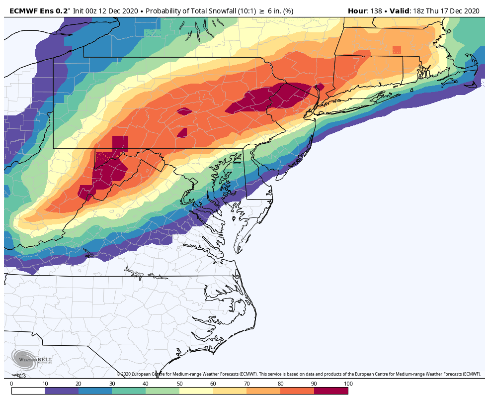
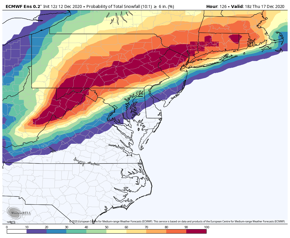
@WxUSAF just quick visual evidence of what I said. The edges tightened some due to some outliers falling off. But look at the 50% prob of 6” line runs. Almost identical at 12z to 0z. The probabilities of the 2 camps hasn’t changed much. 0z 12z


-
Central PA - Winter 2020/2021
psuhoffman replied to MAG5035's topic in Upstate New York/Pennsylvania
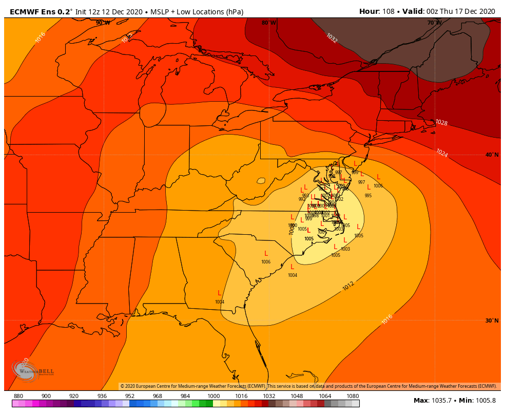
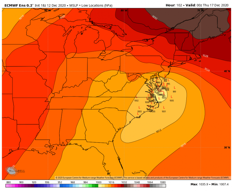
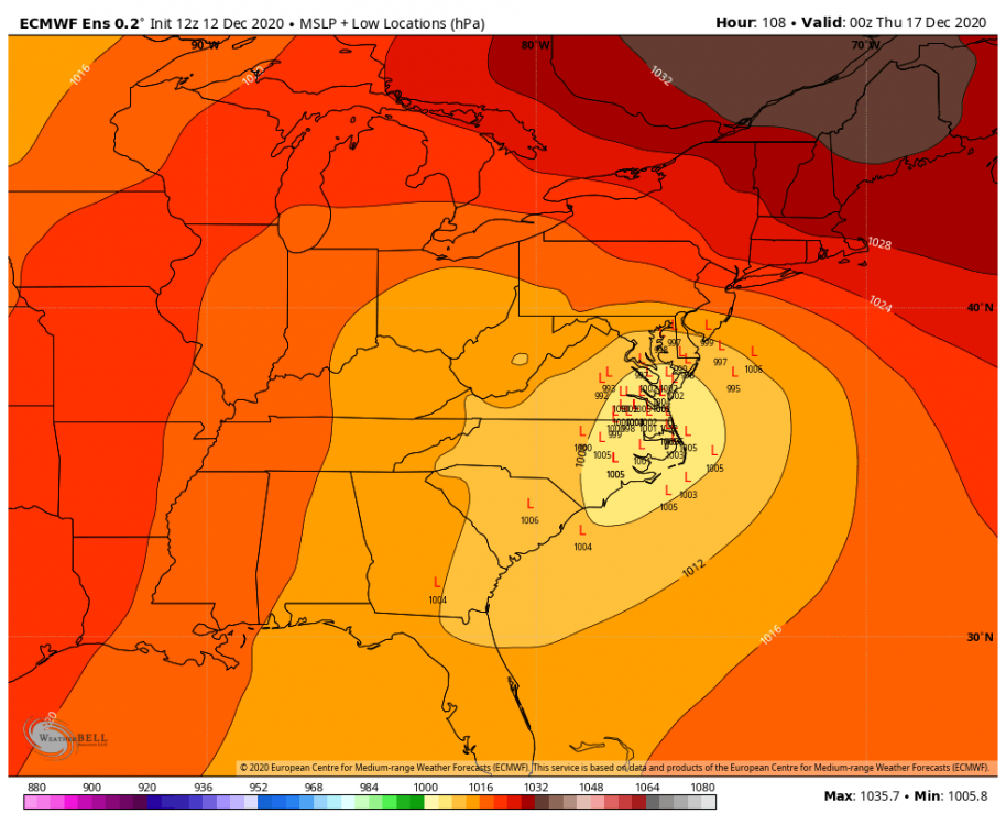
There was a bit of a freak out in the mid atl forum over the EPS looking a bit “inside” at 108 hrs. This really only matters to the SE zones in here but for them I’ll post what I said in the mid atl thread. Since the Eps is based on the op and typically supports it it makes sense it would have the same bias but I can’t say for sure. But Imo the reaction to the 12z Eps is overblown. It’s not as bad as it looks. It’s sort of an illusion imo. There are several factors that make that 108 hr panel look awful. There was always a camp in the EPS going back 48 hours that has a too far inside track v the cluster of tracks that would support a decent amount of frozen. From my analysis I don’t think the % in each cluster changed that much. Several factors made that 108 panel look worse. First a few if the inside runners are way inside this run. But it matters not to us if the track is up the fall line vs up the bay. Both are rain. Matters for Harrisburg I guess. The inside runners are deeper too skewing the mean. Second the timing tightened up. There is way less timing differences on the 12z v 0z so now there is one panel where you can see all the inside runners at one time. Third the timing changed by 3 hours so now that 108 panel catches the storm at its closest inland pass in VA where before most of the lows we’re still down in NC then off the MD coast. We didn’t have one panel on the EPS that caught all the lows at their ugliest look before. By my count if you look at all the panels and estimate (hard to do with some but this is close) there were 21 members out of 50 that were inside of a “frozen supporting track” at 0z. That doesn’t mean the others were all huge hits but tracks that should support a decent bit of snow into 95. At 12z I count 23 inside runners. So maybe 2 more in the camp we don’t want. But that seems like noise to me. I’m not saying an inside runner isn’t a legit fear here. Even up here that’s my fear. I don’t see any way this gets suppressed south. The trough goes neutral and starts to lift pretty far west. The whole flow is amplified. The block/50-50 are anchored a little north of the examples where we see something squashed to our south. Imo this is going to be a hit or too far north and rain. I feel pretty good about this ATT but still a long ways to go. But you know me if there is an “oh no it’s all falling apart” moment I will be the first on here warning about it. The 12z EPS wasn’t that imo. -
@WxUSAF I’m not saying an inside runner isn’t a legit fear here. Even up here that’s my fear. I don’t see any way this gets suppressed south. The trough goes neutral and starts to lift pretty far west. The whole flow is amplified. The block/50-50 are anchored a little north of the examples where we see something squashed to our south. Imo this is going to be a hit or too far north and rain. I feel pretty good about this ATT but still a long ways to go. But you know me if there is an “oh no it’s all falling apart” moment I will be the first on here warning about it. The 12z EPS wasn’t that imo.
-
Since the Eps is based on the op and typically supports it it makes sense it would have the same bias but I can’t say for sure. But Imo the reaction to the 12z Eps is overblown. It’s not as bad as it looks. It’s sort of an illusion imo. There are several factors that make that 108 hr panel look awful. There was always a camp in the EPS going back 48 hours that has a too far inside track v the cluster of tracks that would support a decent amount of frozen. From my analysis I don’t think the % in each cluster changed that much. Several factors made that 108 panel look worse. First a few if the inside runners are way inside this run. But it matters not to us if the track is up the fall line vs up the bay. Both are rain. Matters for Harrisburg I guess. The inside runners are deeper too skewing the mean. Second the timing tightened up. There is way less timing differences on the 12z v 0z so now there is one panel where you can see all the inside runners at one time. Third the timing changed by 3 hours so now that 108 panel catches the storm at its closest inland pass in VA where before most of the lows we’re still down in NC then off the MD coast. We didn’t have one panel on the EPS that caught all the lows at their ugliest look before. By my count if you look at all the panels and estimate (hard to do with some but this is close) there were 21 members out of 50 that were inside of a “frozen supporting track” at 0z. That doesn’t mean the others were all huge hits but tracks that should support a decent bit of snow into 95. At 12z I count 23 inside runners. So maybe 2 more in the camp we don’t want. But that seems like noise to me.
-
I’m late to the party and probably 150 posts behind...but it hits the wall of confluence and turns due east just in time to save DC north. Keep in mind euro is typically the most amplified model (sometimes a little too amplified) so seeing it slightly north of other guidance (initially) isn’t shocking.
-
Central PA - Winter 2020/2021
psuhoffman replied to MAG5035's topic in Upstate New York/Pennsylvania
It’s gonna snow. That’s the analysis. Happy holidays. -
Can you see the pine tree I lit up in my backyard from the bottom of the ridge?