


psuhoffman
-
Posts
27,482 -
Joined
-
Last visited
Content Type
Profiles
Blogs
Forums
American Weather
Media Demo
Store
Gallery
Everything posted by psuhoffman
-
Guidance is hinting at a bit of an inverted trough near the area on Tuesday. Some places could get some nice bands of snow showers with that. Right now the placement would favor just to our northeast. Climo says that’s more likely. But it’s close enough to point out. You never know.
-
Which storm recently was supposed to be a snowstorm? I must have missed that.
-
I dunno the euro has been a big red flag to me. I’ve never really gotten invested in this. Comparing the runs at 12 and 18z the euro made sense. The upper low keeps trending further and further NW. There really wasn’t much of a surface wave along the coast until close to our latitude. That band of heavy previp all the way from the coast wrapped around the upper low looked less likely then the split due to weak to almost non existent forcing in between the developing coastal wave and the upper low. The NAMs now look like the euro. The precip shield blossoms just to our north as the coastal finally deepens enough to produce better moisture transport and lift but we needed the quick thump snow idea. Maybe if we see the surface system trend more amplified sooner or the h5 more elongated towards the coast and less consolidated. Right now there is a big area with not much mechanism to get lift in between and that’s where we are.
-
Whose house has the snow magnet near the northern tip of Fairfax County?
-
Oh yea but I’m sort of hoping we pull that card. I said back in the fall I expected this winter to be pretty awful and the only thing I saw that could save us was if we got blocking. I still feel that way. For my area. You have a lot more ways to make things work up here. I’m just pointing out “if” we do get a west -NAO regime the general pac look we’ve had and look to have can work out. Lots of ifs and buts in there though.
-
Ideally yes. The near record cyclone that blasts in there this week is a killer. But I’m referencing where the vortex has been centered most of winter so far and where long range guidance suggests it pulls back to after the next 10-12 days. We can do ok with lower heights near the Bering so long as a massive vortex isn’t centered there. the look mid January across guidance right now is pretty close to the composite of our biggest snow years and some of our big dog storms. But if you’re talking about why it’s warm the next 12 days or so yes! I was looking ahead. Btw miss your input in the mid Atlantic thread. Please pop in when we have a threat worth talking about.
-
He isn’t wrong for the mid Atlantic though. I’ve run similar studies of our big snow events down here and our best big snow look often has a trough in the N PAC along with a west based NAO block. It’s a big if, but if we do develop a west based NAO block the pac is just fine. Otherwise it’s crap.
-
I dunno. I’m sure the mean is biased positive some by the warmth near Davis but those are some strong anomalies to get at those ranges from just that. You will never see the ridge signature past 10-12 days due to smoothing on ensembles but when I look at most individual runs and the controls there is legit ridging and even a Rex block at times. Plus with the pac trough where it is we wouldn’t see lower heights into the central and eventually the eastern US in the long range without legit blocking. There would just be a wave 1 signature with full latitude trough on the west coast and a full latitude ridge in the east. I think past day 10 the blocking signature looks real imo. Will it actually evolve that way and can it overcome the pac and a scorched N Amer thermal profile though...?
-
The first storm after Xmas (the only one in range of worrying about yet) doesn’t cut. It gets shredded them redevelops as a miller b that misses us. Problem is the NS wave runs out ahead of the SS and gets shredded but it also flattens the heights and squashes the SS until it phases and comes together too late. We need the SS out in front so the NS can phase in to our south. Look at the h5 for most of our big snows (it’s on the climo thread) there is a trough near AK usually.
-

Central PA - Winter 2020/2021
psuhoffman replied to MAG5035's topic in Upstate New York/Pennsylvania
Thank you -
Central PA - Winter 2020/2021
psuhoffman replied to MAG5035's topic in Upstate New York/Pennsylvania
@MAG5035 do you know what resolution the GEFS and EPS members are run at compared to the operational? I have noticed that the ensemble members (of both the EPS and GEFS) are often warmer even with similar or further east tracks then the operational runs. This has been a consistent correlation for several runs across both ensemble suits. The track of the operationals has changed but the presentation of the thermal structure of the storm has remained fairly consistent...meaning where you expect the thermal boundaries to be wrt to mslp. But that seems to be different on the ensembles. I am wondering if they are run at a lower resolution...they may be warmer due to not modeling the meso scale features as well. That may not be correct...just grasping at possible causality for the observation I noted. ETA: I know back in the day the NAM would pick up on CAD better due to its higher resolution...one of the few things it was good for at range with a winter synoptic event. You had to adjust for its over amplified bias...but you could get an idea what the thermal structure of the storm would look like. -
Central PA - Winter 2020/2021
psuhoffman replied to MAG5035's topic in Upstate New York/Pennsylvania
There was a bit of a freak out in the mid atl forum over the EPS looking a bit “inside” at 108 hrs. This really only matters to the SE zones in here but for them I’ll post what I said in the mid atl thread. Since the Eps is based on the op and typically supports it it makes sense it would have the same bias but I can’t say for sure. But Imo the reaction to the 12z Eps is overblown. It’s not as bad as it looks. It’s sort of an illusion imo. There are several factors that make that 108 hr panel look awful. There was always a camp in the EPS going back 48 hours that has a too far inside track v the cluster of tracks that would support a decent amount of frozen. From my analysis I don’t think the % in each cluster changed that much. Several factors made that 108 panel look worse. First a few if the inside runners are way inside this run. But it matters not to us if the track is up the fall line vs up the bay. Both are rain. Matters for Harrisburg I guess. The inside runners are deeper too skewing the mean. Second the timing tightened up. There is way less timing differences on the 12z v 0z so now there is one panel where you can see all the inside runners at one time. Third the timing changed by 3 hours so now that 108 panel catches the storm at its closest inland pass in VA where before most of the lows we’re still down in NC then off the MD coast. We didn’t have one panel on the EPS that caught all the lows at their ugliest look before. By my count if you look at all the panels and estimate (hard to do with some but this is close) there were 21 members out of 50 that were inside of a “frozen supporting track” at 0z. That doesn’t mean the others were all huge hits but tracks that should support a decent bit of snow into 95. At 12z I count 23 inside runners. So maybe 2 more in the camp we don’t want. But that seems like noise to me. I’m not saying an inside runner isn’t a legit fear here. Even up here that’s my fear. I don’t see any way this gets suppressed south. The trough goes neutral and starts to lift pretty far west. The whole flow is amplified. The block/50-50 are anchored a little north of the examples where we see something squashed to our south. Imo this is going to be a hit or too far north and rain. I feel pretty good about this ATT but still a long ways to go. But you know me if there is an “oh no it’s all falling apart” moment I will be the first on here warning about it. The 12z EPS wasn’t that imo. -
Central PA - Winter 2020/2021
psuhoffman replied to MAG5035's topic in Upstate New York/Pennsylvania
It’s gonna snow. That’s the analysis. Happy holidays. -
Hate to be dark but deaths lag cases by about 3 weeks. 18.5 days is the average time from diagnosis to death and then add a few days for reporting delays. If you go back 3 weeks and look at the cases that correlate to the current deaths...and apply that same % to the current cases, we are looking at possibly 5,000 deaths a day around Xmas.
-
Mid-Atlantic winter 2020-21 snowfall contest
psuhoffman replied to AnEndlessMaze's topic in Mid Atlantic
First winter call
-
You are describing the micro effects of the macro pattern I discussed.
-
Split flow progressive pattern with lack of phasing (until OTS). Southern stream moisture stays south. Northern stream races by to the north. It happens. But it’s unlikely to persist forever. Especially as we move into Summer patterns when different factors become more critical to our precipitation prospects.
-
At least this time the map agrees with your point. But a 30 day anomaly over such a relatively small geographic area isn’t that significant. If that kind of pattern were to continue another 60 days or so it would become a problem. My guess is it won’t. These things tend to naturally balance out. These short term anomalies aren’t even really anomalies. The mean is just a bunch of anomalies averaged together. You are missing the forest from the trees.
-
You might want to learn how to read that map before using it to make a point...
-
A small area receiving 50-75% of normal precip for 1-2 months isn’t that significant. That happens quite frequently. For some reason no one makes a big deal everytime we get 150% of qpf in a 60 day period. The drought thing is overblown almost everytime it comes up. We haven’t had a true emergency level drought in a long time. The droughts being trumpeted lately are just typical variance that happens several times a decade. And before some brings up water restrictions...just because some localities didn’t properly plan their water usage when zoning doesn’t mean it’s a true anomalous drought everytime they run out of water due to poor planning and over population for the local water availability.
-
It hasn’t rained here in about 20 minutes. Good thing we are already sheltering in place.
-
Here we go...
-
I think the coop they used there is right on the bay so it skews low.
-
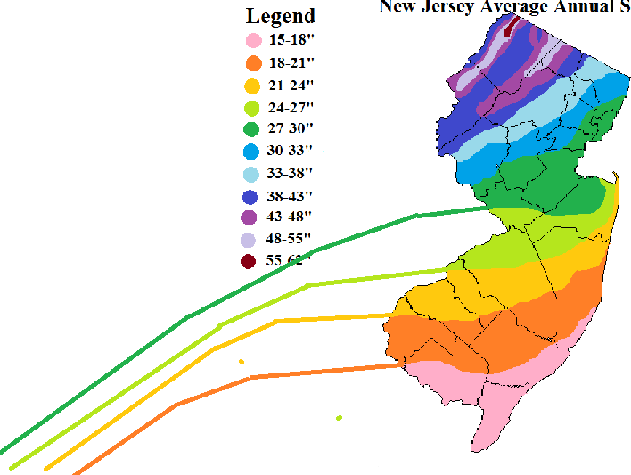
@RevWarReenactor they might not have "lied" to you, simply fallen to a common misconception. West can help wrt snowfall...but only if you get far enough west to enter another climate zone. The reason west helps is because of the contour of the elevation zones in the mid atlantic. If you go far enough west you get out of the coastal plain and into the Piedmont. Go far enough west and you get out of the Piedmont and into the mountains. With each elevation increase you enter a better climate zone for snowfall. But within each zone...north/south matters more than east/west. You can see that with these snowfall maps here...I continued the approximate contours from the NJ map to help show how once you hit the fall line...snowfall totals turn southwest due to the climate zone change...but within the coastal plain the contours run more west to east. You can see on the Maryland snowfall map how there is a tight gradient along the fall line. Had you moved 15 miles further northwest THEN you would have seen a dramatic change in your snowfall. But moving east and west within the coastal plain won't make much difference. Within each climate zone local meso scale terrain features like ridges and water matter more. So being right along the immediate coast...like on the barrier islands...will get less snow than 10 miles inland. But once inland a little snowfall won't usually change much going another 10 miles east or west. Someone right along the Delaware river will get less snow than someone 250 feet higher up in South Jersey for instance. Look at where you are on that MD map...you had the misfortune of moving into a local snowfall minimum also...a region that is between the Chesapeake bay and Delaware river...at very low elevation. Warmth floods up the bay and river.... you have a downsloping wind from every direction...and a wind off water from many directions. You are in a bad local area also. When I moved from southern NJ to northern VA I did see an increase in snow...but only because I went from the coastal plain to the Piedmont. Had I moved somewhere 15 miles further southeast in VA I would have actually gotten less snow than where I used to live southeast of Philly. Elevation is the reason going west helps...but if you go west and do NOT increase your elevation...you really aren't doing yourself any good. And if you go west and put yourself into a local snow hole due to terrain features you can even get less. I get way more snow than places west of me in the valley there. Hope this helps explain the real phenomenon you are describing.
-
First of all I hope you don't find this antagonistic. I don't find any of this to be hostile. We have different opinions but it's an interesting conversation that is all. It has been a crappy run for snow. I am not happy with the results either. But I am taking a purely statistics and probabilities side here. In the last 10 years DCA had 4 years above average. That still holds with the long term "normal" frequency. Those years can sometimes come in chunks with long periods in between...that has always been the case. There is a very random distribution to our big snowfall years. You have to look at the frequency over longer periods of time when you have that kind of distribution to see real trends versus just random noise. Like a coin flip. You can get 5 heads in a row...and think that is a trend...but if you step back and look over 20 or 30 flips you are more likely to see it even out towards the 50/50 probability. Over the long term the odds of a big snowfall year is about 30% and we will have runs of good or bad within but over the longer term it usually ends up evening out to about that 30% chance. I am not trying to say its been a good run for snow. Its been crappy. But the problem is we live somewhere that crappy is kind of the normal base state most of the time. I am just accepting that reality. Not saying you should be happy about it. WRT your take on different years...and how snow comes. Again you feel how you feel...no changing that, but what you describe...late snowfalls (or even mid winter ones) that melt right away...or turn to rain and get washed away...or imperfect storms that dry slot us...that describes A LOT of our snow. If you start to toss years that got to a decent result but did it with "flawed" storms you end up making our already crappy climo even worse. For instance if you remove the "good snow years" in DC where most of that snow came from one big storm OR most of that snow came late in the season then you end up tossing "good years" like 1960, 1972, 1983, 2000, 2015, 2016, 2019... take those away and now your probabilities of a "good year" go down to like 20% if not worse. On top of that a lot of the "mediocre" years become awful if you toss one big storm years...like 2006, or years where most of the snow came from flawed melty storms or late season storms....like 2018. Do that and now the chances of a total crap season goes up even more. So I get why you don't "like" those storms as much...I just don't think you get how rare what you "want" really is. How common has it been for us to get a winter where we get a lot of snow from multiple "cold" storms? How many of those have happened in the last 30 years? 1996, 2003, 2010, 2014, 2015... is that it? Am I missing any? If not that is 5 times in 30 years... that's only 17% of the time. You only have a 17% chance of getting that in any given year. I am not saying that isn't what you should want...and I want that too...I just realize how rare that is around here. I also think you are mis remembering some years. 2002 DC only had 3.2". It was 2003 that was great and that was a nino year. 2004 was only 12.5" so it was decent but not a "good" year, especially by your standards. 2006 DC had 13.6" and most of it came from one storm that was a meltathon right after so doesn't that fall into the type of years you say you don't like? 2008 was only 4.9 all of it came from a clipper in early Dec and then two 1" slush storms. I highly doubt you really thought that was "decent" at the time. 2009 was 7.5" almost all from one storm in March that melted the next day. So.... You are saying some of those werent that bad but they were every bit as bad as some of the years in the last 10 that you complained constantly that they sucked as they were happening. They were all way worse than 2018 was in your location and you hated that year when it was actually happening. I think time has a tendency to edit our memories. 15 years from now maybe all I will remember from this winter is that one good snowstorm I got in January and the day in the snow with my children and it won't seem as bad. But the numbers don't lie.


