psuhoffman
-
Posts
27,419 -
Joined
-
Last visited
Content Type
Profiles
Blogs
Forums
American Weather
Media Demo
Store
Gallery
Everything posted by psuhoffman
-
If we’re lucky
-
The 18zgefs does not agree wrt EPO. Even stronger poleward ridge then 12z. Was probably just an op at range on a tangent.
-
Ha and the block still forces a low under us even after it starts in the upper Midwest...but without the epo we don’t get the expansive cold press so again it’s a narrow as bleep snow area.
-
18z Gfs op lost the epo ridge totally. Instead it’s a flat central pac ridge and we see the results. The blocking is crazy but it can’t offset that pac. Hopefully it’s just a bad op run.
-
Yes.....
-
You expect as deep a pressure along the gulf coast or southeast as a vortex in the North Atlantic?
-
Teenagers close enough I don’t mind engaging with him. In case you haven’t noticed ignoring him doesn’t work. He posted like 15 times while I was teaching a class today and no one said squat to him. After I engaged with him the nonsense posts calmed down...for a while at least until he gets triggered by the next bad run.
-
Does that mean I can claim this one too lol
-
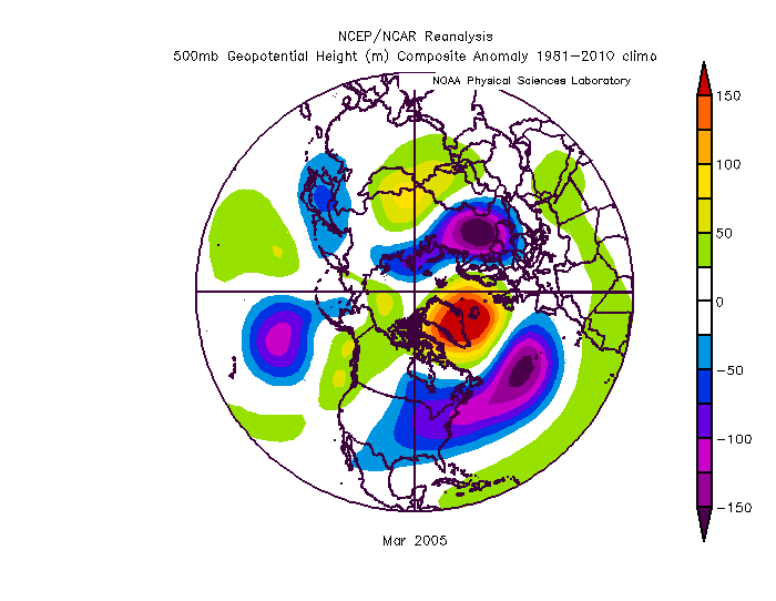
2005 you are thinking of but...we did get 2 snowstorms from that pattern in late February and early March. Both were 3-6” type deals. It was mostly dry after and I would agree it underperformed potential but it wasn’t a shutout and it was March which always is more challenging. We’re talking prime climo here! ETA; that block was more east based also
-
If we waste this we really do suck. This is a once a decade type blocking event.
-
This is the Eps 72 hour mean day 12-15. Honestly you won’t see a stronger signal at that range. Both GEFS and EPS are sniffing something there. It’s been on the GFS op also
-
Fwiw eps thinks rain is the bigger threat day 8-9 not suppressed. Some hits though. Some south misses. It’s not a bad look. But the signal day 10-15 is really strong for that range. If this look holds I do expect to see something worthy to show as that period comes unto range.
-
This is an excellent look. Mean H pressure to our NW with low pressure running the gulf states and up the coast...
-
EPS has a big signal for that range around Jan 25-26. So does the gefs. West to east type wave as blocking relaxes some. Way too far out but it’s there. Remarkably similar on both ensembles
-
If his default is 3” I can understand his frustration.
-
We’ve had a lot of runs less then 3. Since they upgraded the GEFS it’s snow maps have been less stupid skewed high by outliers. But also that’s a 10 day mean not 16. So you’re exaggerating and comparing a 10 day to a typical 16 day map. BTW the euro wasn’t that far from a better solution. we need 1 and 2 to phase. Instead they don’t and flatten each other out. We need 3 to be a couple hundred miles east...or not there at all..timing up a wave rotating down a trapped 50/50 at day 8 is hard. It’s not out of the question. I don’t care about details past about 150 because they change run to run a lot. 150 in I want to see it closer because the adjustments seem to be more incremental once inside about that range.
-
I wouldn’t mind getting the -pna a bit further south out west. A more SE to NE gradient would help. So long as the blocking is ape like that we will need to get lucky we timing up a wave and phasing it to buckle the flow or getting a temporary weakness in the flow...But the blocking will relax eventually and as that happens with a very cold airmass likely rooted in the US...that’s when things could get more interesting.
-
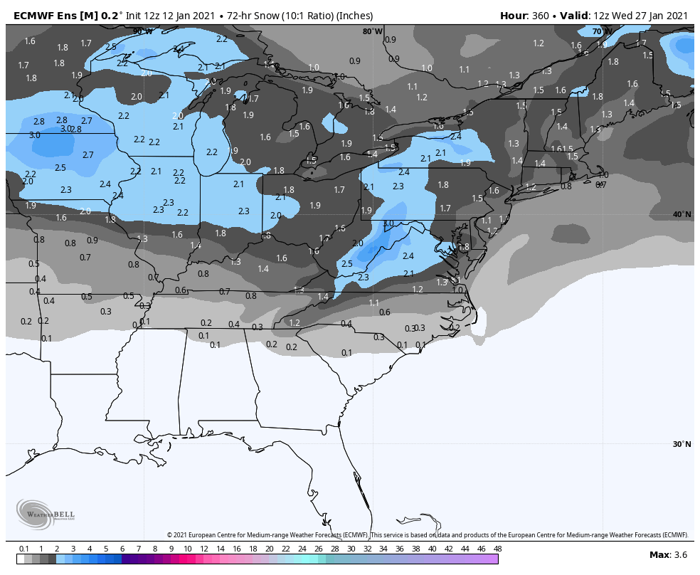
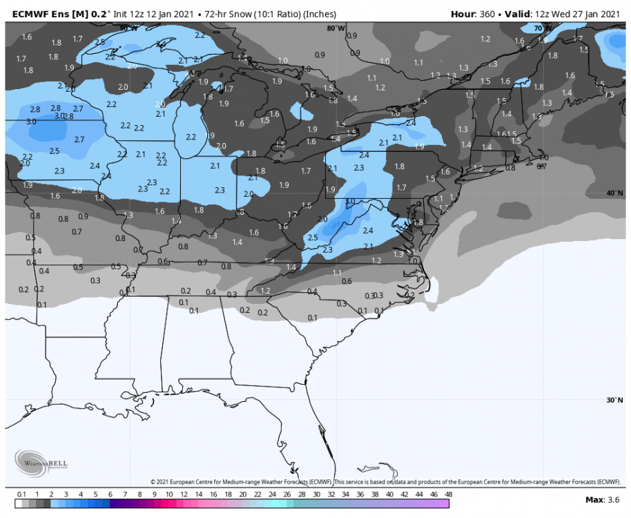
Gefs was a great run. Very cold. Blocking keeps holding stronger and longer..likely runs into Feb now. For those that want to pull hints from clown maps...the day 6-16 snow mean has a max over VA. The snow belt regions will always have a max from upslope and lake effect but otherwise the max snow axis runs just to our south. That’s a good signal. Ji will be along to take a dump on it in 3...2...1...
-
Oh the storm it didn’t even have last run misses us this run. Oh no
-
Too much blocking lol
-
obviously the blocking shows better at earlier times but that’s crazy for day 15 and all the smoothing at that range.
-
The last 2 runs that system was a hit and a miss to the south. Now it is a very close miss north. At that range it’s going to bounce around because very minor details that can’t possibly be pinned down at 300 hours will determine if the storm snows on PA or MD or VA or NC. And some don’t want to hear this but the pattern from the general hemispheric longwave pattern we can see hints of at that range is the same for all those solutions. We’re not geographically far enough apart to see the discreet differences between a PA and a VA snowstorm at that range. A good pattern gets us in the game that’s all. The real key is if this pattern lingers for 2-3 weeks we should get a hit out of the 4-5 waves that would come during that time.
-
Of course not....we should use the pressure difference between DC and Pittsburg to extrapolate the pattern for the next 3 weeks!!!
-
I don’t remember him saying anything. Or are you using what someone else said against him?