psuhoffman
-
Posts
27,409 -
Joined
-
Last visited
Content Type
Profiles
Blogs
Forums
American Weather
Media Demo
Store
Gallery
Everything posted by psuhoffman
-

January Storm Term Threat Discussions (Day 3 - Day 7)
psuhoffman replied to WxUSAF's topic in Mid Atlantic
GEPS loves that threat too. Gefs is more north (good!!!!!)

-
January Storm Term Threat Discussions (Day 3 - Day 7)
psuhoffman replied to WxUSAF's topic in Mid Atlantic
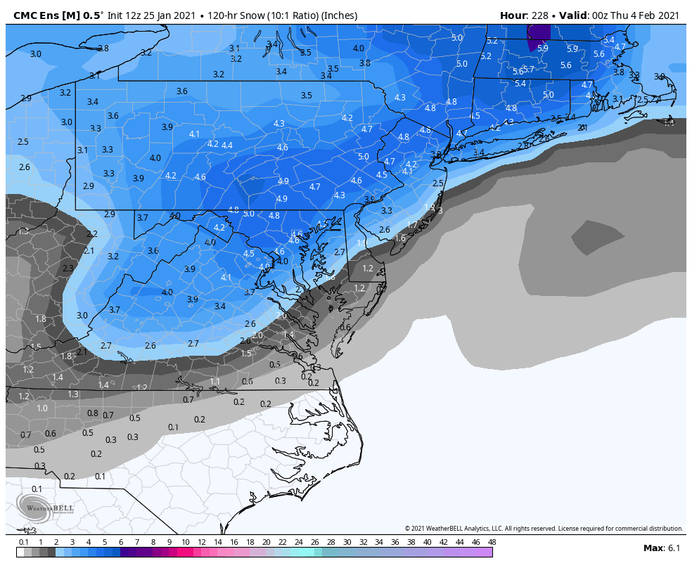
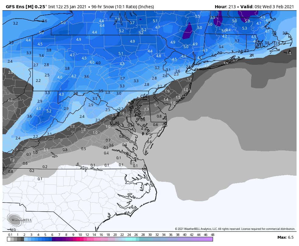
This is the mean for the whole storm. You need to use the 72 hour snow mean to capture it all because there are some timing differences and some members have the secondary stall and linger.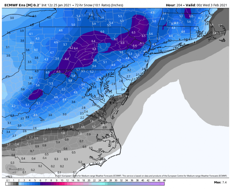
-
January Storm Term Threat Discussions (Day 3 - Day 7)
psuhoffman replied to WxUSAF's topic in Mid Atlantic
Just once... -
January Storm Term Threat Discussions (Day 3 - Day 7)
psuhoffman replied to WxUSAF's topic in Mid Atlantic
You would think if we keep getting GOOD setups one has to work eventually. Right lol -
At least some people still know what's up
-
January Storm Term Threat Discussions (Day 3 - Day 7)
psuhoffman replied to WxUSAF's topic in Mid Atlantic
That’s too much specificity for that range. The weird double barrel h5 pinwheel aside the track of the h5 and surface low adjusted south again. That’s the takeaway at that range. I’m not even worrying about that weird h5 Fujiwara it pulled. -
January Storm Term Threat Discussions (Day 3 - Day 7)
psuhoffman replied to WxUSAF's topic in Mid Atlantic
Very close...big hit for NW of 95. But the trends both now and seasonal are the key. Ignore the gfs also. It’s added more confusion then anything else lately. All other guidance is trending south pretty dramatically over the last 24-48 hours and that fits the seasonal trend. I expect further south adjustment the next 2-3 days. There is a limit to how far south though because this is coming across pretty far north. I’m not as worried this gets squashed south of us as with the Thursday storm. Trends since Dec are south/weaker day 3-7 and a slight north amp bump the final 48. -
January Storm Term Threat Discussions (Day 3 - Day 7)
psuhoffman replied to WxUSAF's topic in Mid Atlantic
-
January Storm Term Threat Discussions (Day 3 - Day 7)
psuhoffman replied to WxUSAF's topic in Mid Atlantic
Dude look how that wave has been trending the last 48 hours. Then look where every storm has trended the last month. Storms that were cutting so far north we didn’t even give them a thought at day 8-10 ended up suppressed south of us! Just pray by the time we get to 100 hours were not looking at another NC snow threat. -
January Storm Term Threat Discussions (Day 3 - Day 7)
psuhoffman replied to WxUSAF's topic in Mid Atlantic
Simple isn’t an option. Simple would be a wave running under us with a nice WAA snow shield. That cannot happen because there isn’t enough cold. Look at the thermals I posted last night from the icon as the wave gets into the plains. It has no snow shield to it’s NE again because there is no tight thermal gradient to focus along. You can go 250 miles and only get a 5-10 degree change because it’s 28 degrees all the way up into Canada where it should be 10 degrees. Because of this we will likely continue to see storms where there is little to no WAA snow shield to the northeast of them. We need some kind of dynamic system that amplifies in just the right spot and given the blocking that’s going to involve some form of west track transfer hybrid system. And yes that’s the complicated way and we prefer simple but without the overrunning option simple is gone. I guess you could consider tonight simple except the snow shield is sooooo narrow because of the factors above its not really simple and it’s pretty limited in potential and scope. -
January Storm Term Threat Discussions (Day 3 - Day 7)
psuhoffman replied to WxUSAF's topic in Mid Atlantic
If the Mjo gets into 8 with a -AO and we still fail lol. We’ve been fighting a somewhat hostile Pac base state. Although I think some are using that as a comfort blanket honestly because the pac forcing has been mostly blah and muted. Definitely not good but not awful. And we’ve overcome a similar pac with a -AO/NAO before. But if we get the pac into a favorable forcing state in Feb and its still not cold enough the excuses start to run out. BTW when I say forcing I don’t mean the longwave pattern necessarily. I have my suspicious the typical response is being altered somewhat. But that altered response if somewhat permanent is irrelevant. If the forcing takes on a typical nino phase 8 look and we still see a hostile longwave pattern....well at least we can eliminate the “we need the pac to cooperate” posts. -
It’s a living
-
Guess I’ve been booted from the forum.
-
January Storm Term Threat Discussions (Day 3 - Day 7)
psuhoffman replied to WxUSAF's topic in Mid Atlantic
Yea that looks off. It’s more like 2-3” which is a hecs by recent standards -
January Storm Term Threat Discussions (Day 3 - Day 7)
psuhoffman replied to WxUSAF's topic in Mid Atlantic
It has some light snow on the front...but when you say it looked nice I think most aren't really chasing an inch or two followed by rain on a day 7 threat. But I am not even worrying about those details at that range anyways...but I agree the way the run was described did not align with what the run looked like. That GFS run the other night was NICE. That ICON was...ehh at least its got some pity flakes. -
January Storm Term Threat Discussions (Day 3 - Day 7)
psuhoffman replied to WxUSAF's topic in Mid Atlantic
I saw that all or nothing dichotomy because either the wave has the necessary amplitude to begin to amplify a surface system and cut off to our west and it would then foster a bombing secondary along the coast that would tuck in tight with the upper low...or it would fail to reach the necessary amplitude and get suppressed by the flow. In between doesn't really work. Its a a critical mass thing to spark the chain reaction we needed...there is a very narrow zone for the in between options...its more likely it amplifies or gets squashed because its too weak. -
Oh no you don't...you started all this by dropping these nuggets for no reason in both storm threads earlier today. You didn't post in banter. And now you want to pull this passive aggressive BS "not the right place" crap because you're rightfully taking a beating for the nonsense garbage you posted.
-
January Storm Term Threat Discussions (Day 3 - Day 7)
psuhoffman replied to WxUSAF's topic in Mid Atlantic
I expect it to keep trending south... I thought it would either amplify enough to bomb along the coast...or get squashed...I never liked the in between option. It's becoming clear which way its going imo. -
January Storm Term Threat Discussions (Day 3 - Day 7)
psuhoffman replied to WxUSAF's topic in Mid Atlantic
I am skeptical of the day 7 threat...but lets see what happens as it gets under 150 to the range where EVERYTHIGN has shifted south since December without fail. Storms that were cutters at 180 hours ended up suppressed south of Atlanta. We need to get the transfer to happen further south then guidance is suggesting right now...but its well within margin of error given the seasonal trend. Now getting the wave to amplify and not shear out...that might end up the bigger problem if we apply the seasonal tendencies. -
January Storm Term Threat Discussions (Day 3 - Day 7)
psuhoffman replied to WxUSAF's topic in Mid Atlantic
There is no sign the pattern just breaks down and we go into a shutout look...but we've had a pretty freaking good pattern all winter and almost nothing to show for it so I don't know what to think or how to even be excited by anything anymore. -
January Storm Term Threat Discussions (Day 3 - Day 7)
psuhoffman replied to WxUSAF's topic in Mid Atlantic
It will if the GFS adjusts the track the same way its been adjusting everything else from that range all winter long. We probably want to see the storm cutting to hudson bay right now frankly. Just sayin -
January Storm Term Threat Discussions (Day 3 - Day 7)
psuhoffman replied to WxUSAF's topic in Mid Atlantic
So many little things went the wrong way...but what sticks out there as by far the biggest issue is again what happened in the Atlantic. The lack of any space between the waves as Thursday's storm reaches the east coast because the previous one lingers there. There is no room to amplify. -
Thank you for contributing...and in case you haven't noticed his ridiculous NWP conspiracy rants drive me absolutely crazy. It's not the stupidity of it...its the extreme disrespect to basically accuse so many people of that kind of thing without any evidence to back it up. The audacity to think its acceptable to just make up some BS like that and impugn the integrity of others without a shred of any evidence to support the accusation.
-
January Storm Term Threat Discussions (Day 3 - Day 7)
psuhoffman replied to WxUSAF's topic in Mid Atlantic
I have always wondered how current models would have handled some of our past storms that busted pretty close to game time. Like 1996 when we still expected most of the snow to stay south until about 24 hours out...or 2000 of course. -
January Storm Term Threat Discussions (Day 3 - Day 7)
psuhoffman replied to WxUSAF's topic in Mid Atlantic
it was "ok". It got some WAA snows over our area. I guess the totals are measly but honestly I don't bother to look at that at those ranges. But again...the wave is falling apart as it tries to press east under the blocking...from 992 in KS to a 1009 shearing out mess near Detroit. It tried to secondary and was close to something nicer though. I was mostly kidding about "the one" stuff. I posted a couple times earlier on that threat...the setup had potential but it also shows some of the same limitations we have been suffering from all year. Look as the storm is crossing the plains...notice AGAIN the lack of a significant snow shield on the north side of the storm like we would expect from a decently amplified mid winter mid latitude system. This thermal profile is disgusting! There is no strong gradient...no thermal boundary to focus baroclinicity and amplify the surface system. And the system again looks more like what we expect from a late March/April storm and it starts to shear out as it heads east absent a nice boundary for it to focus along and amplify. What we would need for this to work is to get the upper system to crash in and phase with a secondary along the coast kind of like the euro op did but a little further south. That is not off the table...there are hints at that progression in the guidance...but again its a situation where we are left needing the complicated intricate 10,000 steps all have to go right solution to make this work because the simple way to get snow...ride a system along the thermal boundary and get some nice WAA up over a cold air mass is removed from the equation. Remember Bob used to say we do simple well...we don't do complicated. Well everything has to be complicated when you remove true cold from the equation.