psuhoffman
-
Posts
27,419 -
Joined
-
Last visited
Content Type
Profiles
Blogs
Forums
American Weather
Media Demo
Store
Gallery
Everything posted by psuhoffman
-

January Storm Term Threat Discussions (Day 3 - Day 7)
psuhoffman replied to WxUSAF's topic in Mid Atlantic
Yes but we should remind ourselves as @CAPE said...they can also be frustrating as hell because they suppress and often we have to wait and wait and wait and it’s typically as it breaks down or relaxes that we get our best threat. -
January Storm Term Threat Discussions (Day 3 - Day 7)
psuhoffman replied to WxUSAF's topic in Mid Atlantic
I would say the EPS supports the op...more then I expected Seriously the south trend can stop RIGHT THERE!!!!!

-
January Storm Term Threat Discussions (Day 3 - Day 7)
psuhoffman replied to WxUSAF's topic in Mid Atlantic
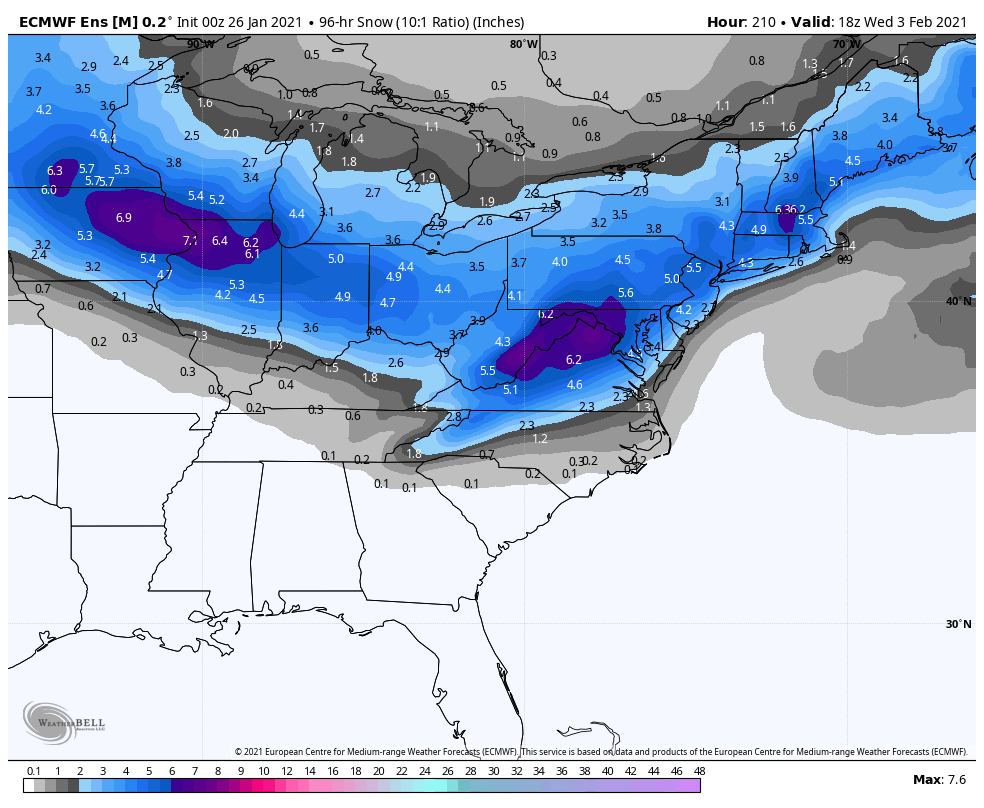
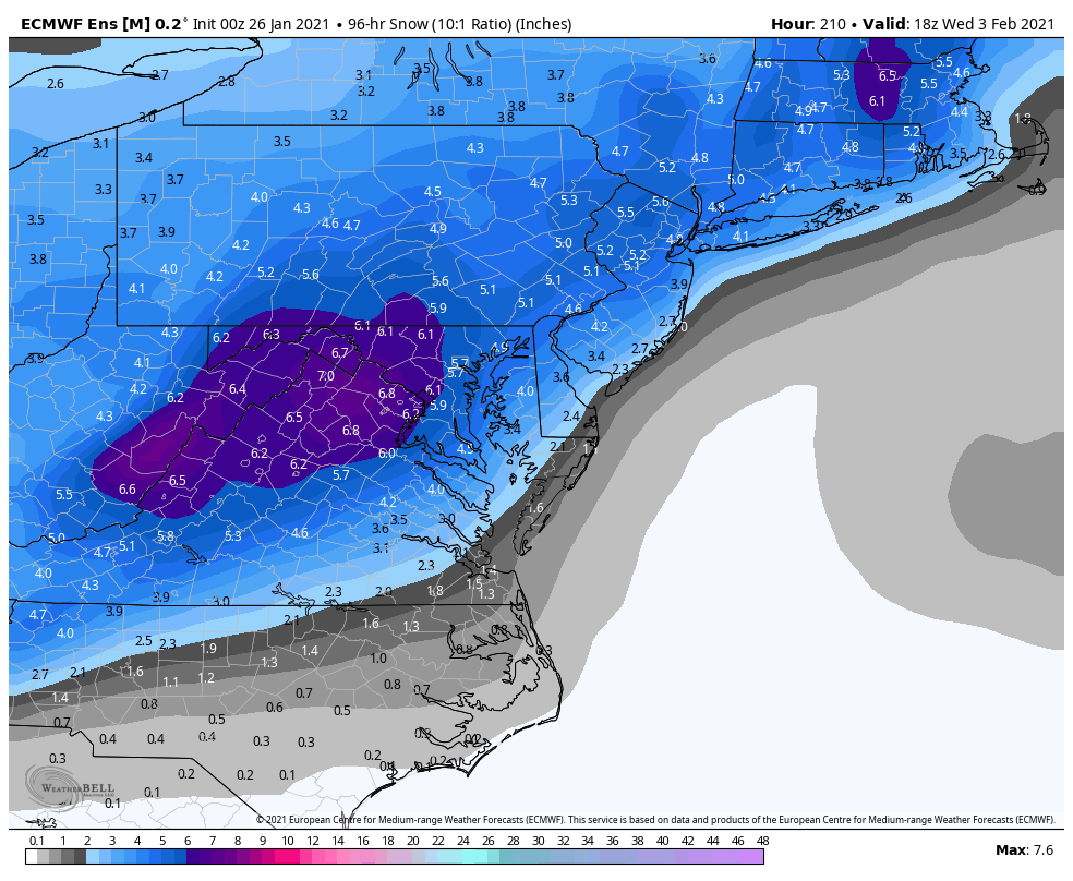
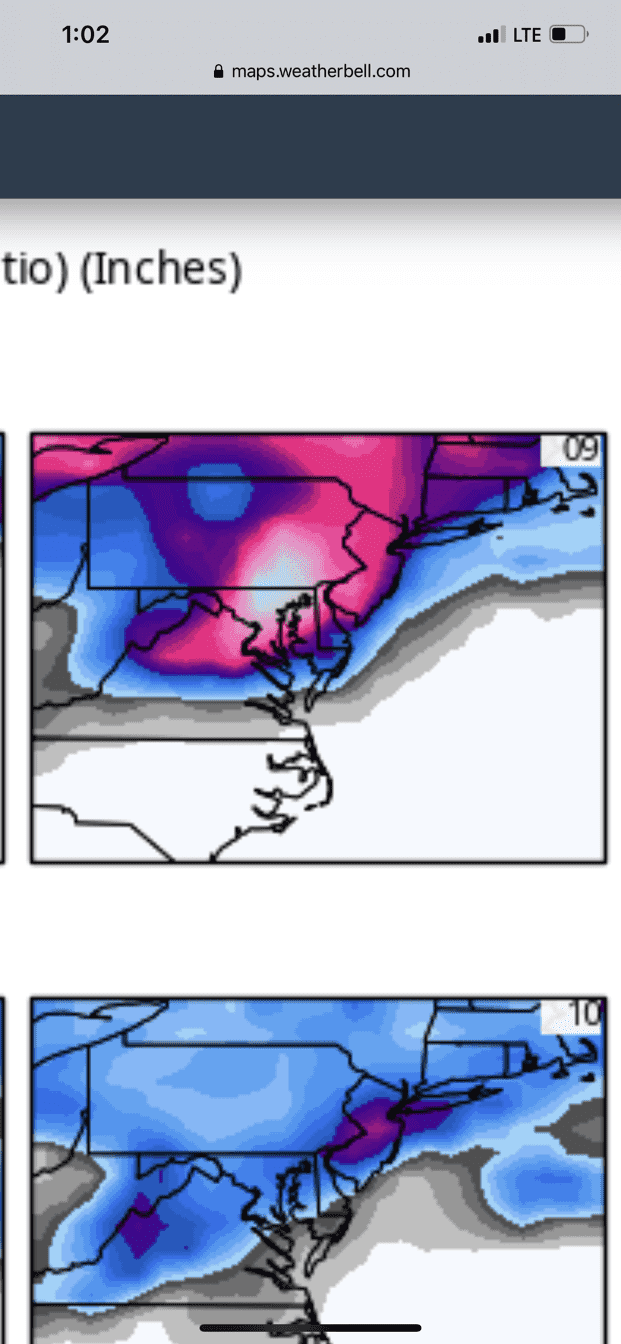
Total EPS QPF for the storm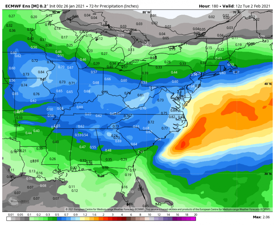
-
January Storm Term Threat Discussions (Day 3 - Day 7)
psuhoffman replied to WxUSAF's topic in Mid Atlantic
Impressive wedge for that range -
January Storm Term Threat Discussions (Day 3 - Day 7)
psuhoffman replied to WxUSAF's topic in Mid Atlantic
EPS -
Feb Long Range Discussion (Day 3 and beyond) - MERGED
psuhoffman replied to WinterWxLuvr's topic in Mid Atlantic
Geps agrees -
Feb Long Range Discussion (Day 3 and beyond) - MERGED
psuhoffman replied to WinterWxLuvr's topic in Mid Atlantic
The GEFS is trending the wrong way for them. -
Feb Long Range Discussion (Day 3 and beyond) - MERGED
psuhoffman replied to WinterWxLuvr's topic in Mid Atlantic
The relaxation looks brief. By mid Feb we look right back into it. I guarantee if everything else there is correct that SE ridge won’t last long. plus even with that ridge the cold is pressing. Look where the boundary is. Looks like the pattern is rebooting only with a lot more cold to work with.
-
January Storm Term Threat Discussions (Day 3 - Day 7)
psuhoffman replied to WxUSAF's topic in Mid Atlantic
We’re getting inside the range everything else started to fall apart. This one is trending better. I do think there is a limit to how far south this one can go given its trajectory. -
January Storm Term Threat Discussions (Day 3 - Day 7)
psuhoffman replied to WxUSAF's topic in Mid Atlantic
I’m not done yet -
January Storm Term Threat Discussions (Day 3 - Day 7)
psuhoffman replied to WxUSAF's topic in Mid Atlantic
I’m going to need some quiet time alone with this Euro run. -
January Storm Term Threat Discussions (Day 3 - Day 7)
psuhoffman replied to WxUSAF's topic in Mid Atlantic
? Lol -
January Storm Term Threat Discussions (Day 3 - Day 7)
psuhoffman replied to WxUSAF's topic in Mid Atlantic
Yea the coastal gets suppressed but a nice front WAA thump. Ji: but we lost 18”, at this rate by tomorrow we’re going to owe it snow -
January Storm Term Threat Discussions (Day 3 - Day 7)
psuhoffman replied to WxUSAF's topic in Mid Atlantic
This one is coming across at a higher latitude...the blocking is relaxing... I do think there is a limit to how far south this gets suppressed...but if you told me we get no snow from this wave...I guess gun to my head...it gets squashed is still the bigger risk vs it cuts enough to be all rain. -
January Storm Term Threat Discussions (Day 3 - Day 7)
psuhoffman replied to WxUSAF's topic in Mid Atlantic
This one... we get to pick right? Isn’t that how it works?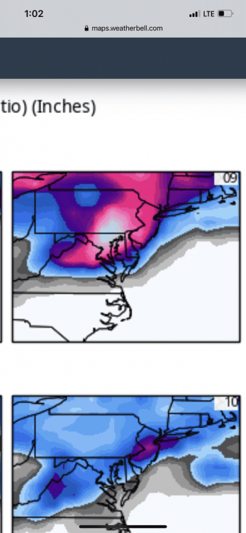
-
January Storm Term Threat Discussions (Day 3 - Day 7)
psuhoffman replied to WxUSAF's topic in Mid Atlantic
Geps trend last 4 runs... ok the south trend can stop now -
When's the snow gonna start?
-
January Storm Term Threat Discussions (Day 3 - Day 7)
psuhoffman replied to WxUSAF's topic in Mid Atlantic
I said its complicated not it wont work. I see that option...I also could see that "capture" missing and the storm slides out. Both are possible permutations. -
January Storm Term Threat Discussions (Day 3 - Day 7)
psuhoffman replied to WxUSAF's topic in Mid Atlantic
just saw your surface map.... that is pretty textbook if it were not for that vortex over Maine I would say its bob chill face worthy...but that complicates things. Could squash the secondary development due east...we need it to gain a little latitude from where its at 144...not a lot but ideally we want it to move NE from there to off the delmarva then east. It might move due east under that vortex in NE -
January Storm Term Threat Discussions (Day 3 - Day 7)
psuhoffman replied to WxUSAF's topic in Mid Atlantic
@yoda Where is the secondary forming at 144? -
January Storm Term Threat Discussions (Day 3 - Day 7)
psuhoffman replied to WxUSAF's topic in Mid Atlantic
Ehh...what's it got going on over New England??? That is a bit too much... Love the h5 low placement but hard to see the coastal really amplifying much with that sitting on top of it. It would be CLOSE to something bigger but I dunno with that there. But were worrying about details too much for 144 hours. Not a bad thing to have something a little south when the other 3 globals were all a little north so far. -
January Storm Term Threat Discussions (Day 3 - Day 7)
psuhoffman replied to WxUSAF's topic in Mid Atlantic
That could even be a little too far south...depending on what the coastal does after. LOL -
January Storm Term Threat Discussions (Day 3 - Day 7)
psuhoffman replied to WxUSAF's topic in Mid Atlantic
Gefs 24 hour trend -
January Storm Term Threat Discussions (Day 3 - Day 7)
psuhoffman replied to WxUSAF's topic in Mid Atlantic
Yea man...I'm not buying these 995 primary nw of us...I'm willing to sacrifice the waa snow Sunday for a much bigger chance Monday Check out the changes at h5. This was a better run imo if we want to get the big coastal option. -
January Storm Term Threat Discussions (Day 3 - Day 7)
psuhoffman replied to WxUSAF's topic in Mid Atlantic
@Ji look at the h5...I actually like this CMC run better then 12z. The h5 tracked further south and more amplified...it was closer to a BIG storm for us imo just had the primary hold on slightly too long...but given the seasonal trend I would go against an over amplified primary into the ohio valley. The rest of the run was better...better h5 track, better cold press in front.