psuhoffman
-
Posts
27,419 -
Joined
-
Last visited
Content Type
Profiles
Blogs
Forums
American Weather
Media Demo
Store
Gallery
Everything posted by psuhoffman
-
Cant wait for this event to end so we can go back to the long range. Im so over 3 hour events You're one of a kind lol
-
It's almost go time Currently the surface low is over south central VA moving ENE towards the lower Ches Bay. The upper level short wave is rounding the base of the trough in KY and about to cross through WV then VA later tonight. As that happens VV's will be increasing across the area. That area in SW VA right now I have circled is going to be the main show for the DC/Baltimore area as that lifts NE with the best vorticity associated with the mid and upper level energy. It should be fun for a few hours. This is an excellent profile to maximize snow growth across the area during the passage of this feature. I expect some nice ratios and big fat fluffy OMG flakes.
-
when I told it I said spread the word
-
Wine seems to be popular in here
-
I told it
-
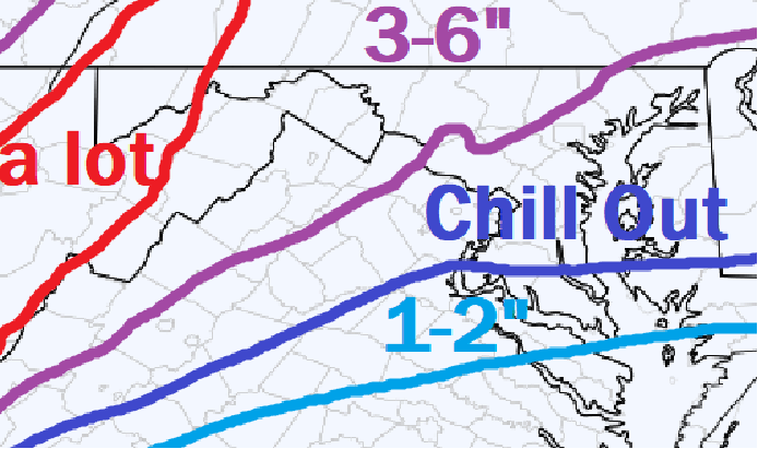
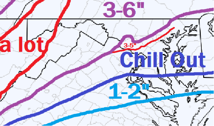
I like what I am seeing now. Reports to our SW show this is overperforming if anything. That band ripping to our NW is a good thing...that banding riding along the jet was NOT supposed to be our snow. The actual radar matches the sim radar from the GFS and Euro, both of which were decent to good for our area in general. But the intensity of whats happening just to our NW shows what kind of environment we have for anyone that ends up in banding later on as the primary and upper level energy tracks across VA and we get into better lift. If anything I am MORE optimistic right now than I was earlier. Oh and chill out.
-
Best I could do
-
what the GFS said it should look like right now... LITERALLY
-
Ya I saw that but its kind of perplexing because they are getting a dump of snow tonight...and then cold through Saturday...but its going to rain pretty hard Sunday so if they don't get it open by saturday....well...the "by the END of the weekend" part is confusing.
-
Great to have you back fighting the good fight!
-
It's not THAT big a difference across guidance, we are all just obsessing over meso scale banding placement which is a nowcast detail. In a much larger storm who gets 28" v 22" isn't as big a deal. In a much "wetter" storm along the baroclinic boundary with lower ratios small .1 QPF differences arent as big a deal when were talking who gets 5" from .5 and who gets 7" from .7. But this is a type of setup where small qpf differences make a big OTG difference but that fact still doesn't make us any more able to place meso scale features accurately. They just told ya'll to chill out too I did my job, you have been lead to water trough...its not my fault if you dive head first into it and drown!
-
tell them to get western territory open for my by Saturday!
-
It's not even supposed to be snowing in our area for about 5 more hours...some ya all need to chill. WRT radar, it looks exactly how its supposed to look. The banding streaming off to our NW is supposed to. That isn't what brings the DC area any snow. As the upper level energy now over KY/WV emerges through VA later tonight that banding down to our SW will transition across the area. Everything looks exactly like it should on radar to me. Not worse, not better...the way its supposed too. WRT the HRRR and RUC they are eratic as all get out. From one storm to another they can be good or just plain awful. But the difference isnt that crazy. There was one run that was 1.2 QPF but most runs of the HRRR have been around 1.5-1.9 QPF. With expected ratios thats about 2". We are expecting 2-4" so thats on the low side but not that out of range. Some of the better guidance (except the GFS which is probably on crack) is closer to .3 QPF which would be the 3-4" possibility with good ratios. I guess if you were expecting this to suddenly explode into a 6-12" snowstorm then it looks like a disaster so far but if you are expecting the 2-4" that was generally advertised by most guidance lately...everything looks fine imo.
-
Flakes have commenced. oh and it’s snowing too!
-
I’ll tell you what stuck out to me when I searched for that answer. Gfs has a much more consolidated and vigorous vort max and because it’s associated with the primary it causes that to be the focus of amplification and associated banding vs transfer to the coastal secondary. Other guidance has a less focused vort with several weaker vorts that fails to support the primary enough to stave off energy transfer to the coastal, which is what causes the relative qpf minimum across our area.
-
Balance has been restored to the force
-
Thanks for the kind words. One of the times I went to Revelstoke BC I ran into an older gentlemen in his late 60's looking for someone to hit the backcountry with. He showed me some great terrain and then we had a few beers. He was still able to do all the terrain I could handle and made it look easy! lol. There is hope for us all!
-
wish the actual storms were as predictable as these threads
-
I spent several years heading out west, after I originally learned in the east, for 1 or 2 trips a year instead of skiing the east, really love Revelstoke and Jackson Hole. I like to ski off piste a lot so grooming isn't a big concern of mine. Obviously nothing in the east compares to most of the resorts out west or in Europe but if you time your trips right and hit up mtns after a snowstorm it can be good skiing. Snowshoe is the best of the mid atlantic mountains and its not even close imo. Now I will say I have not tried Timberline since its ownership change and reopening. I've heard good things. And that mountain has a ton of potential. But under previous management it was a mess. Awful slow lift, boring trails with similar terrain, no moguls or natural terrain, and just run down feel to it. If they are running it right, have some nice bumps and variety and I know they have a new fast lift...maybe that can compete now. You are right the front side of snowshoe only has about 800 ft vertical. But there is a backside with 2 trails that have 1500. It is only 2 trails but they also have some glades in between the trails. The front side isn't so bad though, there are 2 nice gladed runs, a couple of nice mogul runs, and the lifts are fast enough it doesn't feel too awful with the lack of vertical. Snowshoe gets dumped from upslope events from the west. Additionally I have always been impressed by their conditions despite challenging weather. They recover from a hard freeze pretty quickly and make a ton of snow fast. All in all for this area its the best. For the east coast though nothing beats northern Vermont after an upslope event where Stowe, Sugarbush, Smuggs, or Jay get crushed with feet of powder. They all have some decent tree skiing and natural terrain and get enough snow that if you time it after a dump its worth it. In the spring Sugarloaf in Maine is awesome, they don't get nearly as much snow but hold their snowpack very well into April and May, but its a freaking grail quest to get there. Also look out for cold and wind in New England. You don't want to go up there if its the middle of a brutal cold period. They lifts might be shut down due to wind anyways and it can be -20 with a 30 mph wind and frankly no matter how tough you are and how well you dress its not going to be a fun experience. I've skied out west in colorado when it was -20 and it just didnt' feel nearly as awful as a couple times I made the mistake of skiing in Vermont in -20. Just don't do it!
-
Gfs is way more focused with the mid level VVs right through our area. Euro is extremely diffuse with multiple vort maxes all over which doesn’t facilitate the banding the Gfs has and instead focuses the greater lift to our east which allows the combo of downslope and subsidence to do our dirty work up 95. Looking at other guidance most is somewhere in between with 3k NAM closest to the Gfs.
-
If you want to look smart say 2-5 everywhere. 90% will verify. When in reality we know there is likely to be a zone of 3-6 with a zone of 1-3 but placing those exact bands is risky and really just an educated guess.
-
Gfs doesn’t have the resolution or the physics to resolve fine details like banding and sharp edges due to subsidence around banding. It smoothed everything which gives a too expansive representation of precip along sharp edges. It’s very subtle, one of those things where we’re right near a critical mass switch flip and models can’t decide which side we end on, but the deciding factor seems to be how much energy transfers to the coastal v simply amplifying the primary associated with the SW. Runs that key on a quicker transfer and amp the coastal more v the primary less, cause 2 effects. It interferes with the south and easterly flow around the primary cutting off better moisture transport. And it develops a more intense deform band along the coastal front sooner which puts a subsidence zone over our area. The models that amplify the primary more and coastal less delay that process, or in the case of the Gfs simply never really develop the secondary and just have the primary amplify and merge with the secondary, so the initial band intensifies after the mountains as it crosses our area aided by a nice southeast moisture influx from the primary. I tend to like to use the euro for Synoptics like where to expect a feature then the higher resolution models for what the exact details of said feature will look like. That’s not 100% and I definitely factor the Gfs and other data into it and can nudge the euro representation one way or the other but that method has served me pretty well as a “starting point” from which to build on in the past.
-
I suffered this morning for waking the kids up so late.
-
If anyone ever wants to get some turns and a few beers in let me know!