psuhoffman
-
Posts
27,419 -
Joined
-
Last visited
Content Type
Profiles
Blogs
Forums
American Weather
Media Demo
Store
Gallery
Everything posted by psuhoffman
-
 A SSWE early Feb in 2018 is speculated to have caused what happened that March/April. It's plausible an event in late January could start to impact by the second half of Feb. But we've seen the SE ridge win in every other scenario so why are we confident the results would benefit us? It could just dump arctic air into the west again and pump the SE ridge to the north pole.
 -
I'm sorry that sucks. I had to cancel a trip to snowshoe last winter when the kids got sick. If the long range guidance is correct Feb could get really ugly... if so my full attention will turn to my PD trip out west shortly lol. Another option is Vermont. Killington is really awesome for the kids. They have a really good kids program, and the back side of the mountain isn't very crowded and has very easy green trails all the way down to the base. It's really not THAT much further than snowshoe and doable if you take a day off and make it a 3 day weekend. Even if we torch odds are Vermont will find its way to a snowstorm or two sometime in February, I would imagine...god I hope so or they are FOOKED because they have absolutely no base right now and ski season is kinda half their economy. Even past torch years like 98 were NOTHING like this. I went up to Vermont a couple times that winter and they actually did ok because enough of those rain storms were wet snow up there and they had a pretty good base. I can't remember a year where mid January the ski resorts up there had absolutely no natural snow base at all.
-
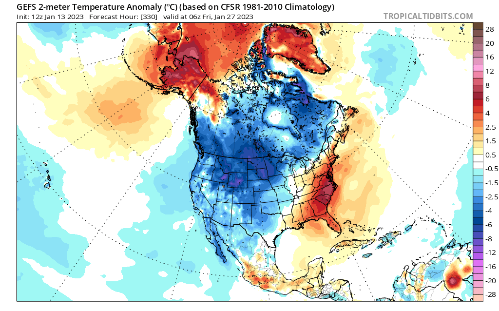
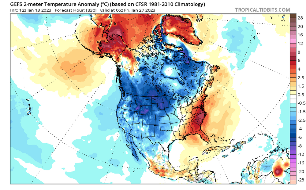
The GEFS flips the pattern in the Pacific exactly opposite...totally reverses all the blues and reds...and the result is exactly the same for us.
-
https://www.snowshoemtn.com/media-room/skidder-slope-live-cam Heading up tomorrow. Will be in the pool/hot tub tomorrow afternoon and on the slopes with my kids Sunday and Monday. There are ways to survive this with your sanity intact.
-
Well we are about to go from "its warm everywhere" to "its just warm HERE". Baby steps and all that jazz.
-
I am almost positive Ji was just trying to be funny. But if he was actually being mean spirited, highly doubt it, then the way you responded wouldn't exactly have been the most effective way to deal with it anyways.
-
It was a joke...
-
it looks great for Winter Park where I will be PD weekend...Ya'll should come along.
-
It would be cool and interesting to have the data and it might be enlightening to find previous periods similar to this one so we have better comps to use. But it wouldn't be that relevant to what we are doing here because when we analyze the weather history is a huge deal. When the very knowledgeable posters here break down these day 10 looks in here to analyze our snow chances that analysis is based on what we know historically is a good pattern for snow and what the cause effect relationships are that work out in our favor. We aren't basing our expectations and discussion on some other climatological period in the 1600's. Now maybe having more data would show another cycle like this...and a long frame of reference would show us some data useful to this current period...but my guess is that is so long ago no ones expectations are going to be based on something that happened before their great great great grandparents were born. What happened in our lifetimes or in the more recent past is always going to skew perceptions so we would probably still be lamenting "things are bad" compared to our recent framework.
-
But the issue is there is way too much crossover between the pattern and the fact it’s warming to avoid some bleed over. Because a lot of the analysis we do in winter is centered on “is it gonna snow” and the analysts we do of the long range pattern is grounded in historical precedence and expected outcomes, it’s relevant and stupid to just ignore it. The issue seems to be that when it comes up in relation to the pattern the simple mention of it upsets some. Some for emotional reasons some for political maybe I dunno, but that then starts a side debate about it and then veers off on a tangent and I get the result isn’t good. Take today. I didn’t talk about climate change at all. I simply refuted some claims that “this is just a normal cyclical thing” by showing the data that this is the least snowy period ever. That’s it. Then I addressed some individual “causes” you brought up one by one and said there is more to this than to just keep cycling between different variables as a cause but I didn’t say the elephant in the room. But we have to discuss what’s impacting the pattern right? But that started 20 posts on climate change again because everyone knows what’s really going on. I do understand I just think it’s kinda silly and a lost cause.
-
I am a very analytical person, I enjoy a debate, and I like science. This hobby isn't making me miserable. I still enjoy the discussion and debate around the science. Yes I love snow. Yes I want it to snow more. Its annoying me that its not snowing but that is not making me miserable. I am about to go to lunch and I will be enjoying it. Later today I will pick up my children and I will be very happy to give them a hug. We will enjoy dinner. This weekend we are going to snowshoe and will have a wonderful time. The fact it didn't snow is not going to ruin my day or my life. On a list of things I am more upset about or concerned with...whether Jalen Hurts shoulder will be healthy enough by next weekend is higher on the list than if it will snow. I can go see snow whenever I want somewhere...I can't go see an Eagles super bowl anytime I want. My failed marriage was something worth being upset over... snow is insignificant compared to REAL problems. This hobby is an escape from real problems. I like to analyze. I like to debate. I actually enjoy this. Yea I would enjoy it MORE if it was snowing but I would enjoy it less if it wasn't AND I wasn't analyzing the weather. Not right now...not until the kids are older. But the next 18 year period starting in 5 years....by the time we get that far into THAT period I likely won't be here anymore. I do plan to move somewhere closer to skiing and more snow once the kids are older.
-
Its my fault. I saw a bunch of "its not really that bad" posts and simply wanted to show "it is that bad, worse ever actually" and that sparked another climate debate which isn't really what I wanted to do. We've had that several times already recently. But the problem is there really isn't much else to discuss either so these tangents take over. One decent long range GFS op run isn't really worth that much discussion either.
-
I started the current period because NWS starts climo periods after the turn of a decade. So eventually our climo will start with 2011. It wasn't meant to skew the data. I used 18 instead of 30 because I wanted to put it in a reference we can understand...but 18 is the shortest period you can use and still claim much statistical significance. But it doesn't change the equation as much as you would think for 2 reasons. First going with 7 years before the bad stretch also brings a historically snowy season into the period of record for the previous "least snowy" period on record also. Not quite as snowy as 2010 but close enough that it mutes the impact of changing the years. Second, it does change the equation with the mean some but it doesn't impact the median or probabilities of snowfall season to season much at all. And that has been my point all along...our mean is skewed by a couple good seasons a decade but the REAL story is how much worse the typical seasons in between those rare unicorn snowy years are becoming. Since we spend 80% of our lives in those years...what its like in those years is actually more important IMO to our sanity that the fact it snows a shit ton (its a technical term) in years like 2003 and 2010 and 2014. It's all arbitrary where you start and end a period. If we start a period with the snowiest year on record that kinda skews things the other way...and the fact that starting the current "18 year period" with the snowiest year ever still doesn't make this period look that good is indicative of how bad its been.
-
I think when we do get truly cold, then your hypothesis is correct and we’ve seen it. Problem for us is 2 fold. 1) that’s such a minority of the time what’s more likely is the ridge impact. 2) even when that happens we are seeing it result in very tightly wound bomb cyclones focused off the coast where the warmest SSTs are NOT tucked in where we need them to get a big snow into the 95 corridor. It's been a net L
-
I’ll probably be living in Colorado or northern New England for most of that next period.
-
But we’re not supposed to talk about that in here. We’re supposed to just endlessly chase fake day 15 patterns and pretend this is normal.
-
You just said what I was trying to say way better in way less words.
-
None of my point was specific to this pattern, although I am seeing some signs we may still end up with similar problems discussed above coming up. But we will see. I was just seeing a lot of "its not that bad" or "its this or that one thing" kinda posts...and neither really captures the reality imo. Maybe I am wrong and in the next 5 years we go on a 1960's level epic run...but that is what we're talking about here...its been so bad we dont just need like a few 20" seasons or one 40" season to pull out of this...we actually need some EPIC historically unprecedented makes the 60s look like 2020 5 year run just to avoid this being the WORST PERIOD EVER! Now back to analyzing what's in front of us for better or for worse. Just had to get that off my chest.
-
We don’t need to have the why debate in here. I was just trying to end the “it’s not really that bad” claims. It is that bad. The why debate can happen in another place.
-
If you go back over several days it’s slowly bleeding the wrong way wrt SE ridge and pna. Another mid latitude system during the coldest month of the year with absolutely no appreciable frozen WAA precipitation to the north of the track until you get north of 43*!
-
@Maestrobjwa please skip this post, seriously just don't read it, its not going to be good for your health. Before I respond to some specific things I've seen lately let me first lay out the case that THIS IS NOT NORMAL...its not just a normal cyclical thing. Remember it was back in 2019 to 2020 that I was on the other side of this. Because the people going overboard then were doing it prematurely. There was a LOT of precedence for a several year run of low snowfall following a generally good stretch from 2010 to 2016. But I know the data, I know the historical cycles, and we are way way past that now. I am not going to get into what is causing it...we don't need to bring THAT in here. Maybe its a confluence of several factors all coming together at once, and I do think there is SOME of that...and I will get to those things later in this post also but first simply the facts that indicate this is not just a typical funk as I continue to see some claim. I've gone into the trends and numbers at DCA but just a quick comp to previous bad cycles to show this is not normal. Lets look at that 1970's period people like to bring up. That was the previous next worst 6 and 7 year period other than this one. But it wasnt AS BAD. At BWI for instance this period has been 3 inches worse. That doesn't seem like much but lets look at some other factors also. IMO the pattern was actually WORSE then...yet they had better results. Compare H5, and keep in mind this is using current normals so you have to adjust for that. But look at the longwave pattern mean. The 1970's had a RAGING positive AO/NOA and extremely -PNA the entire time with pretty much no EPO help either. This is the worst possible M5 mean you could ever make. This is a classic awful look. If we got this today it would be a total no hope shit the blinds pattern all the damn time. Look at the current period to compare. Yea this is bad...the Pac ridge is west of where we want it...but on the means it actually is extending into the west coast more...the PNA isn't as awful, this is way more EPO help...and the AO is actually averaging slightly negative over the period with a neutral NAO. This is not good but its not as bad. But the results are worse. Imagine what our results would be in that 1970's look now. Would it be 80 degrees in January with that look up top and that pacific now considering what we have had in results with a less hostile overall mean pattern. Additionally 6 and 7 years isn't really long enough to get a full scope of a period. Lets use 18 years again since that is considered a minimum number to get a significant mean for most statistical analysis. If we look at past 18 year periods...take the 1970's one for example. It was bookended with a big snowfall period in the 60's and late 70's/early 80s. That makes this current situation a lot more dire because by comparison the snowier period that preceeded our current funk did not stand up to the snowy period on the front end of that 1970s drought. To put it numerically...for BWI to end the current 18 year period starting in 2011 with similar results to that referenced previous "WORSE PERIOD EVER" BWI would need to average 32" of snow the next 5 years. Think of that...just to equal the period everyone is citing as the "its been bad before" we need 32" every single winter the next 5 years... Now because some of those years before and after that 1970's period were so huge a better comp for a longer period might be 1938 to 1955. There was no 7 year stretch nearly this bad but there also was no 1960's and late 70s snowstravaganza. But even that period BWI would need to average 27" the next 5 years to match. Lets me honest that aint gonna happen, this 18 year period will be by far the worst in history at BWI. Using BWI since many feel it is way more representative of more of the region...but the results are the same just slightly higher overall. DCA would need to average 34" the next 5 years to be better than that 1970's 18 year period, but to be more fair again, DCA's worse 18 year period EVERY was 1942-1959. DC will need to average 25" over the next 5 years to equal that. How many of you want to make a bet with me that DC averages 25" of snow over the next 5 seasons? I'll take that bed. My kids need to go to college...so please let me know if you want in on that action. So can we please stop with the "this is just cyclical and its happened before" nonsense. No this has never happened before. Its never been close to this bad before if you really dig into the data. Even just looking at this year tells the story. We have had several different patterns now...each time I look at the analogs. They have never been great. But none were shutouts. We keep getting analogs to blah periods but ones that did produce SOME SNOW...not a total shutout. Yet here we are. @Ralph Wiggum man you were all over the place... Just last night you said It's solar, but 97-98, Nina, WAR, but the MJO... ok lets address all these Solar...ok but we have not had solar flares non stop for 7 years and there is a lag actually so I doubt the solar flare a few days ago is what is causing our problems right now. Certainly wasnt the problem in December. 97-98...fair enough but even if you want to say that's the comp to this...and to be fair it was the top analog for a while, THIS IS WAY WORSE. Yea you can cherry pick one location like DCA where its the same 0 and 0. But not far from DC there was snow. My area had a 3.5" snowfall late December. Several 2-3" snows during the early winter that year also. I was up over 10" by now. Here I sit at 0. This is not specific to my location. Places not far NW of DC had a bad but not awful amount of snow by now in 98. I was in east central PA that year and we had already had several pretty decent snowstorms by now...the same location has had almost nothing this year. This year is WORSE. Both were bad...this is worse. Nina...this is kinda revisionist history. 2017 was a cold neutral following a super nino. 2018 was a legit Nina. But 2019 was a nino and 2020 was a warm nuetral following a nino. 2021 to now was a nina but if we go back 5 years the mantra was...its the NAO, why can't we get NAO help anymore...when we had 2 seasons in a row with a positive NAO. Remember that...for years all anyone blamed this on was the AO/NAO. But then we started getting -NAO and -AO periods that did us no good and suddenly the new vogue thing to blame it all on was the MJO. Then we got some MJO phase 8/1/2 that did us no good and now its just the really lazy "its the pac" crap. We keep changing "what the problem is" but the one constant is a SE ridge that is more than our snow chances can survive regardless of whatever the du jour "problem" is at that moment. We've had a pac ridge, pac trough, positive AO, negative AO, whatever...doesn't matter the SE ridge remains a problem the vast majority of the time. MJO??? first of all phase 3 becomes a colder phase as we head into Feb...but what about Phase 1 and 2. You just skip right over the fact we are going to torch right through the cold phases then use the warm phase we head into 2 weeks from now as the excuse for the warmth? Sorry that doesn't fly for me. WAR... yea but the WAR is an effect not a cause. That's like saying your headache is causing your brain cancer. Maybe we should be discussing the AMO more. Now...I do think some of this might be a confluence of things all going wrong at the same time. This combo of the PDO and AMO is a really bad one. I am not denying that the general longwave pattern isn't really good. But its not the worse we've ever seen...yet its been the worst results we've ever seen. Past periods with this confluence of AMO/PDO weren't good but they weren't nearly this bad either. But my 2 main points are no this is not normal, this is by far the worst period ever in recorded history for our area and there is way more going on here than all these singular excuses we keep cycling through to try to explain it away.
-
You had 50 inches 2 years ago and Texas froze to death. Winter can still be fierce thankfully Of course it can but we’re talking degrees. The AMO point is valid and we’ve struggled in previous AMO periods but not to this extent! In 2021 I was the southern edge of snow when past comps said it should have been snowing into VA. Look at the analogs this winter. Everytime I check they’ve been bad but not shutout bad. Most of the years that have been spit out at various times were low snowfall pwriods. Not no snowfall!
-
But if speculation the WAR is a result of warming SSTs and if those are permanent umm…
-
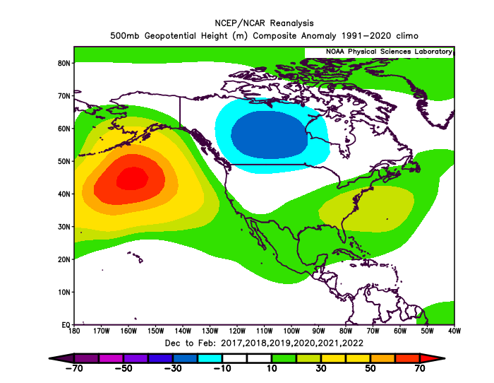
The se ridge is just a response to when a trough dives into Los Angeles. His question is why is that happening no matter how the pac looks. I'd say the last 5 winters...the blue is on the west coast 80% of the time lol There could be something too that though. Think about the flow. As the flow goes up just off the west coast and into western Canada the wave in the west SHOULD be forced east. If there is nothing causing a kink in the flow. But if there is resistance to the flow east (think of putting a stick in the water and watching the flow back up around it) that would cause what we’re seeing. Something on the Atlantic side is resisting troughs professing east.
-
Nina’s cause a -pna because a canonical Nina causes a central pac ridge which naturally favors a pna trough. That doesn’t explain why when we get rare favorable pac forcing to press that ridge east the trough still doesn’t progress but just cuts off under it. That has to be resistance downstream. Troughs either lift or cut off out west even when the longwave pattern upstream suggests otherwise. Something on the Atlantic side is a problem also imo.