psuhoffman
-
Posts
27,419 -
Joined
-
Last visited
Content Type
Profiles
Blogs
Forums
American Weather
Media Demo
Store
Gallery
Everything posted by psuhoffman
-
Let’s move all this discussion here for maestro’s sanity sake.
-
 look at the 850 anomalies. This isn’t as close as you are painting it for our area. Unless we just want some front end freezing rain.
 -
This is another two things can be true. Also some are wired differently. I remember in high school I scored a goal late in a game we were down 5-0 and some teammates wanted me to celebrate and I was like “no just put the ball on the fucking spot and let’s get this embarrassment over”. I know that’s not a perfect analogy but I’m doing two things at once here. Yes I’m the moment I’d enjoy a 4” snowstorm. But I’m also really hopeful I’m dead wrong and the people saying this is 100% bad luck and we’re about to come storming back and restore our climo are right. Im hunting for evidence. One 4” storm to bring me to 10% of normal isn’t even a drop in the bucket wrt that.
-
I am talking about trends up to NOW and how they impact is now. That’s pertinent because we base a lot of our analysis on historical normals for patterns. Take my post in banter last night about the euros rainstorm for the mid Atlantic despite every pattern indicator being perfect for a snowstorm. My point when I said “I don’t even know what I’m looking for anymore” was right now when I analyze a long range pattern and see that look my expectation is a snowstorm and when it ends up a 40 degree rain literally I’m not even sure what to look for anymore. That doesn’t mean the trend doesn’t change in the future. I dunno. Also two trends can be true as I’ve said. I do think we get more snow soon. But I don’t think we get so much more that we offset the lack of snow recently. On the short scale we will get a snowier period ahead but likely the longer term down trend will also continue. That’s my gut. But that doesn’t mean I’m saying it’s never gonna snow again or won’t ever be snowier periods ahead.
-
I disagree on how likely we are to get much snow from that. It’s better yes. But it’s going from a 0/10 to 3/10 imo. Analogs to that aren’t good. Some are total shutouts. Some have a tiny bit of snow. Some minor events. If we had that look long enough we probably would get some snow but that isn’t a snowy look just not a no hope shit the blinds one. But it’s not worth being excited about either. To quantify if that was a monthly h5 mean for Feb I would buy BWIs over under at 4”. That’s still below avg and pathetic considering it’s coming off a complete blanking
-
I’m talking about NOW. Right now. I don’t know what May or may not happen 50 years from now and frankly I don’t care. I have my suspicions but I’m not been going there. Y’all do that.
-
@Ji there can also be different trends on different time scales. By belief that on a longer scale the downward trend is real is not in contradiction with those saying better times are ahead. I do strongly believe BWI will get more snow in the next 7 years than it got the last 7. I do think on a shorter timescale we’ve been in a down cycle. But do I think BWI will average 30” over the next 7 years which is what is necessary to balance out the last 7 and get the larger period back to “normal”. No. So I believe both can be true. Yes we will likely get a significantly snowier period ahead soon. Maybe BWI does average 25” over the next 7 years. But that would still mean at the end of that period the longer term down trend continues and BWIs longer term snow mean will have continued to decline. I see a lot of one statement being misused in relation to another. They are independent things. Just like when I say a pattern doesn’t look good doesn’t mean we can’t luck into some snow somewhere. Getting some snow is normal. Just means a good run where we actually get above normal snow isn’t likely. But if I say something is trending bad or it’s not a great pattern suddenly I said it’s never gonna snow again.
-
@JiTo be more specific a SE ridge is a good thing for Chicago. So if there is a large scale change that’s increasing the SE ridge it might help them and hurt us.
-
When did I say it’s going to be crappy in the future? I’ve said repeatedly I can’t say that for sure. All I’ve done is present the data that shows the trend. Everyone else drew the obvious logical inferences from that. But don’t get mad at me.
-
Not true at....when the west/Midwest is seeing above average snow and were in shutout modre...its all about the pattern. The whole country can't be cold and snow The Midwest isn’t getting a lot of snow. The only places getting a lot of snow are higher elevations out west. Higher elevations and places north of our latitude aren’t good comps to us. For example, if the hemispheric pattern were to shift in a way that shifts the thermal boundary north 1 degree but also increases baroclinicity and precip events that would be a net benefit to snowfall in high elevations and places north of us but a net negative for us. I don’t wish to rehash this in detail. That was just an example. If you want to dig deep into this we can go over to the climate change thread. But I’m simply pointing out that using increases in snow in places that have a totally different snow climo with no correlation to us and get snow in different ways is a bad way to make the case you’re making. The same factors that might hurt us could help them.
-
Who is we? Usually when one area dosnet get snow another area flourishes This sub forum region. There are a few exceptions, most notably the coastal regions that keep taking advantage of the bomb cyclones that I do think are associated with the warmer waters but do anyone west of of bay no good. Some higher elevation locations have done more respectable too by still taking advantage of some of the marginal events that failed along 95. But the vast majority of the population of this forum are in a drought. Even up here it’s been really bad. Ya I’ve had more but my avg is 3x higher than DC. Everyone makes a huge deal that I hit 50” 2 years ago but that’s only slightly above avg here and the year before was the worst season in 50 years here, and we had 3 years below avg preceding that and last year was also way below avg. One slightly above avg season surrounded by 6 below avg years isn’t doing ok. If you mean other parts of the world who cares. It doesn’t matter to us at all that Tahoe is getting 200”. That has no correlation to our snow. They get snow from completely different mechanisms than we do. A larger scale pattern shift that’s bad for us could be good for other places. I can’t stand when people bring up snow somewhere else that has no correlation to our climo as if that somehow has something predictive to say about our snow prospects.
-
Two things can be true. 1) It will snow again and there will be another HECS. 2) we are in the worst snow drought in recorded history and lately it’s been a lot harder to get snow than it used to be Those two things don’t have to start a back and forth everytime one or the other is brought up. They can coexist.
-
Please we’ve had -3 NAO blocks recently where we cant even get any negative anomaly. And before anyone says but the pna there were several periods In the 60s with a -pna and a trough across the whole conus because of a block!
-
@Ralph Wiggum I agree with @Bob Chill. Are there ways to score in that look ya. But we’ve seen this pattern plenty the last 7 years and has that been working out for us lately…(checks data) umm. We would need timing and we’d be rooting for weak waves which given the circumstances seems blah @WxUSAF let me admit my expectations given my location probably make me even more disillusioned than most. In what was the absolute worst winter ever up here 2020 when DC had no snow I had 14” here by now! We’re about half way through and I need 17” just to avoid the worst season ever! And simply not being the worst ever isn’t my bar or target even in a bad year. And that’s not unrealistic when 95% of winters here, even the awful ones, at least get to 20”. So the prospects of licking into some 5” messy event does absolutely nothing. If I finish the season with 10” it’s by a huge margin the worst winter ever up here. So seeing a “well that not gonna be good but maybe we luck into one minor wave eventually in that” doesn’t do much for my feelings on this winter. I have a lot further to go here ironically. DC can get a 6” storm and suddenly this year catapults way up the list to a bottom 30% but not bottom 1% winter. Here i need 17” just to not be the worst! Lol That said if I do get one snow I’ll enjoy it in the moment but I separate those 2 things. When long range pattern hunting I’m a big game Hunter. What’s the point of over analyzing some low probability pattern that would require a ton of luck to work when none of that will be evident until close range anyways. If something pops up day 3 with a legit chance in a flawed pattern ya I’ll be in on it and excited. Just can’t bring myself to get excited about a huge -pna se ridge long range looK with “but if 20 details all go our way we could get some front end mix” kinda thing.
-
What if…we get a 2003/2010 type Nino and DC gets 8” next year. Then do I have permission to start sacrificing people who try to say “but it’s this or it’s that”? Lol
-
look at the ridge axis along the west coast then look at the extent the trough is stretching to avoid progressing east. That was what I meant the other night when I said this isn’t the pacific. Even when the pac is perfect there seems to be resistance in the flow to getting a trough into the east for any meaningful length of time. Something else other then just the pac is feeding it. And this is why a big -epo arctic flow pattern isn’t actually correlated to snow here. This is actually the way more common outcome from an epo ridge. A -epo +pna is a rare combo. It’s difficult to get that longwave configuration. A -epo usually dumps the cold west of us and pumps a SE ridge. That’s why a way better pattern for snow here has always been ridging across central Canada and the NAO domain. But that combo usually comes with a +epo and it’s not a really cold look which is why the vast majority of our snow, even if you go back to the 1800s when we got a lot more, has always come with temps near or even above freezing! Arctic cross polar flow patterns are 1) rare and 2) not even usually a good longwave look to get an amplified storm off the east coast.
-
EPS fully caved to the gefs. Dumps the trough into the west and pumps the SE ridge. But we already knew. Frankly, it could have been the CRAS, as soon as anything showed that didn’t we all go “yup that’s exactly what’s going to happen”.
-
Nothing anyone has said on here had ever offended me. It’s just discussion and debate. Not personal. None of your points was wrong. I just felt there has to be more to it since none of those factors explains it all and it’s unlikely to get so many things to combine randomly.
-
Great 2 more mins a day everyone can clearly see my ugly mug.
-
@JiExplain this one to me. Flow is off the North Pole. And I’m not cherry picking if you look at the run the pac pukes been cut off for a week at this point. It’s a CP airmass. 50/50 feature as storm approaches. The flow is so good the storm gets too suppressed. And… Its just a rainstorm. No frozen even on the NW fringe in the coldest snowiest part of winter with a CP airmass and a suppressed track. Lately I don’t even know what we’re supposed to be looking for anymore!

-
I don’t care about the climate change angle. I mean I care but not in the framework of on this forum. Nothing we say here is going to do a damn thing one way or the other. What I find annoying are those that want to get bent when presented with simple facts and data because it might not agree with a preferred reality. I don’t care if that reality is because of politics or an emotional attachment to frozen water vapor! And the data doesn’t even have to mean the trend will continue forever. Maybe the 2% are right and this warming is just cyclical and 50 years from now it gets colder and snowier again. But why does that even matter? I don’t care what happens 50 years from now. I’ll be long gone. I’m using data to say how our climo has changed from some x period 25/50/100 years ago to right now for predictive purposes NOW! That’s important because a lot our analysis is based on the concept of expectations based on these historical norms. That’s pertinent to a pattern analysis discussion. Why is that even controversial? We all know why, but I’m not playing that game. I’m just using data to show how probabilities have changed to be useful in a predictive way. Because of extreme variance which is increasing locally our snow data can be presented in ways that cover up the underlying trends. But the most significant factor to me, as stated above, is that the “most likely amount of snow X in a given season Y” is declining significantly. Yes we do still and will still get big huge snowy seasons once in a long while. But what is the most likely outcome in all the other years is getting worse, and pretty significantly so! To me anyways what happens in 85% of the time matters more than what happens the 15% of years like 96/03/10/15….
-
Ya now do median and individual seasonal probabilities. That chart is proof of “you can make numbers say anything you want”. Presenting the data in that format hides 3 facts. 1) Within the variance is a long term decline. 2) the seasonal variance is increasing. 3) the odds of seeing a specific amount of snow, X, in a specific season is decreasing. Those are facts but this is my spin/preference. Number 3 is the most significant. The “what is the most likely amount of snow in any given season” value “x” is declining significantly. While it’s cute that once in a blue moon we can get a hecs or a 50” season the vast majority of our lives are spent not in one of those years. It matters way more to my satisfaction what happens the other 80-90% of the time! And that’s where the decline is greatest. If you remove all seasons that are an anomaly (more than a standard deviation) the decline becomes crystal clear! We’ve always had big years and bad and variance. But the variance has shifted to where what is most likely to happen in any given year is radically lower. I ran the numbers a couple years ago (so it’s only gotten worse) and at BWI the “what is the most likely value X in a season” had declined from 21 to 14. That matters to me way more than the fact every 8 years or so we get some 60” snowmageddon. Those don’t happen often enough to offset the losses in the rest of the years Imo.
-
Lol no one has harassed anyone. No one has said it will never snow again. But I’ve seen simple data and facts about what has been happening. And I’ve seen people who can draw their own conclusions then feel harassed by it when it’s not the picture they want.
-
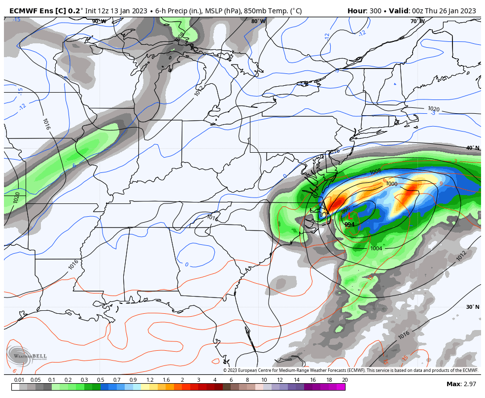
The euro still ends up nothing but rainstorms, it just mocks us by doing it with a perfect pattern.
-
@Jithis is more depressing than the Gfs. Look at that setup. Tight wave spacing. System still over New England as the next wave entrees the Midwest. All that ridging over the top. Ridge pressing into the west. And it’s not enough. Not even that close. Ends up a New England event.