psuhoffman
-
Posts
26,411 -
Joined
-
Last visited
Content Type
Profiles
Blogs
Forums
American Weather
Media Demo
Store
Gallery
Everything posted by psuhoffman
-

Mid January/Mid February Medium/Long Range Discussion
psuhoffman replied to WinterWxLuvr's topic in Mid Atlantic
The 0z gfs showed one reason why there weren’t a lot of regular small to medium hits in the ensembles. That track (up through eastern TN) with any cold at all would be 3-6” before a flip. And with cold that low likely transfers to the coast from there instead of tracking due north and then who knows. But the bottom line is even a track that normally with simply typical winter cold can support “some snow” isn’t even close it’s all rain. Likewise a perfect track but weak system would be rain. We need to get CCBd to death to get snow. It’s an ultimate thread the needle. -
That sounds perfect
-
Mid January/Mid February Medium/Long Range Discussion
psuhoffman replied to WinterWxLuvr's topic in Mid Atlantic
February 1958 had some similarities to the euro track and location of the phase and your area had more from that so it’s possible... -
Mid January/Mid February Medium/Long Range Discussion
psuhoffman replied to WinterWxLuvr's topic in Mid Atlantic
Well add the eps to the “flip up top” camp. Again I don’t care what the day 15 details are. Seeing all guidance weakening the death grip the PV has up top is good news. -
Mid January/Mid February Medium/Long Range Discussion
psuhoffman replied to WinterWxLuvr's topic in Mid Atlantic
Right now at least, guidance is indicating there isn’t enough cold air for a marginal setup to work. Light precip will be rain. A questionable track will be rain. A perfect track but not amplified enough will be rain. The only snow scenario is a perfect track amplified storm that CCBs the living hell out of us such that dynamic cooling overcomes the thermal deficiencies. That’s why you’re seeing the mediocre ensemble results imo. -
Mid January/Mid February Medium/Long Range Discussion
psuhoffman replied to WinterWxLuvr's topic in Mid Atlantic
@Bob Chill I did see material improvement wrt the h5 setup though. Leading into it look at the 50/50 signal. That 50/50 Hudson Bay ridge combo puts us in the game at least There is enough to like here... nice western ridge, that h5 track is classic. The 50/50 departs a bit faster then ideal and I’d prefer the ridge centered by Hudson not east but it’s close enough to the +AO big storm composite look actually Its a shame the airmass is atrocious. That’s why the results are lackluster. Every variable has to be spot on perfect to work. If we had a colder antecedent airmass I bet the ensembles would be lit up like a Christmas tree right now. -
Mid January/Mid February Medium/Long Range Discussion
psuhoffman replied to WinterWxLuvr's topic in Mid Atlantic
I guess I had lower expectations. There are flaws. Just because this one op run spit out the damn perfect set of permutations we need to make this work doesn’t make that suddenly likely imo. It just means it’s within the envelope of possible. -
Mid January/Mid February Medium/Long Range Discussion
psuhoffman replied to WinterWxLuvr's topic in Mid Atlantic
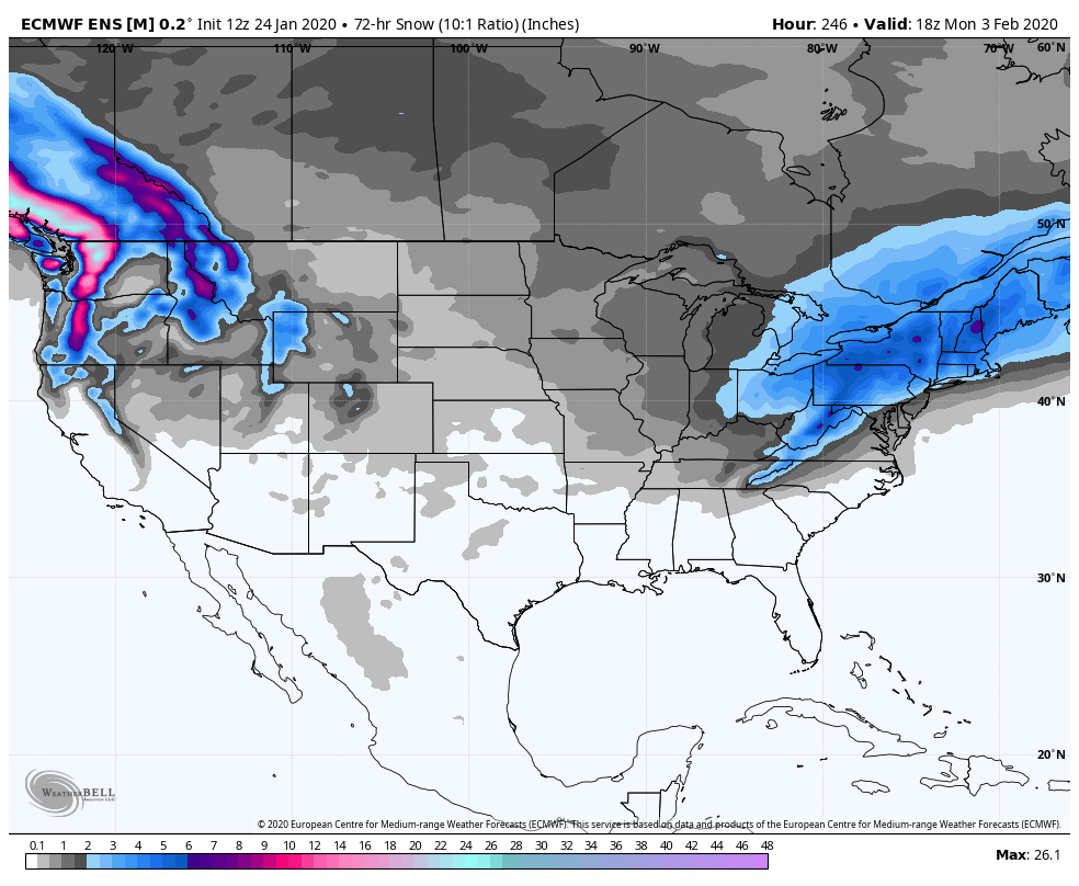
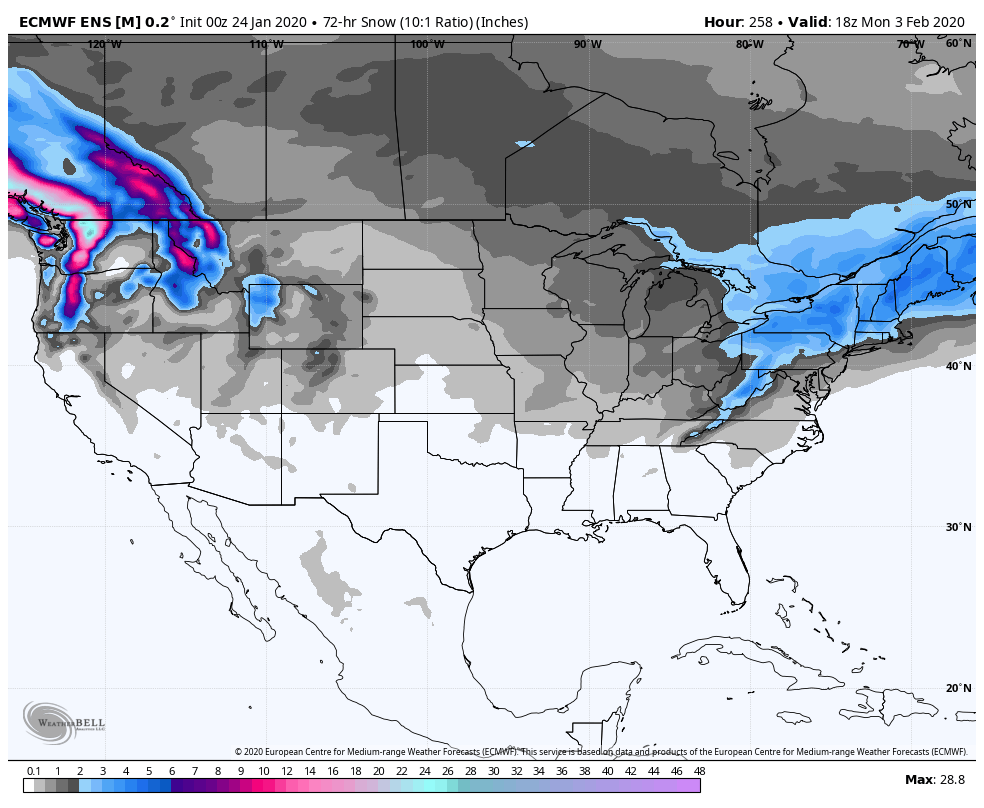
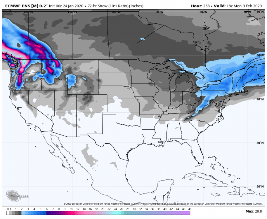
It was better than I expected at that range. Obvious improvement from 0z. This isn’t the best way to illustrate it but it’s the easiest and I’m busy 72 hour mean snowfall 0z 12z
-
Mid January/Mid February Medium/Long Range Discussion
psuhoffman replied to WinterWxLuvr's topic in Mid Atlantic
@Ji look at the h5 track. Base of the upper level trough goes across the TN/KY border through southern VA then closes off as it passes just under us. That’s the “Goldilocks” upper level look I was talking about yesterday and this morning. This was close to the perfect run. Only thing that could have maxed it out more would be a little weaker NS system initially and stronger STJ wave to wrap up the coastal 6 hours sooner...then you get that 12-24” area down here...but that’s getting really picky and if you wrap the low up too early you get the rain solution again so it’s a thin margin for error with barely any cold in place. -
Mid January/Mid February Medium/Long Range Discussion
psuhoffman replied to WinterWxLuvr's topic in Mid Atlantic
Yea...it’s one thing when we get totally shafted but as long as I get a warning level event obsessing over “who got more” seems silly. Just ruins what is a rare opportunity to be happy as a snow weenie. -
Mid January/Mid February Medium/Long Range Discussion
psuhoffman replied to WinterWxLuvr's topic in Mid Atlantic
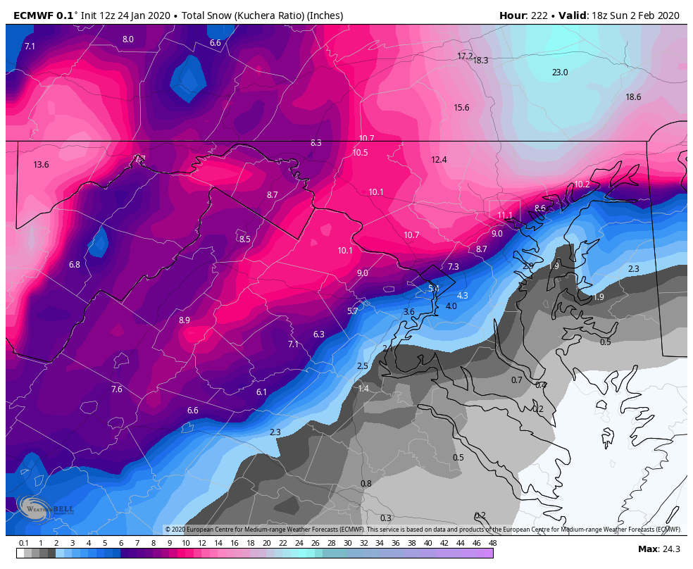
This is the only map we care about... 15” here...check please.
-
Mid January/Mid February Medium/Long Range Discussion
psuhoffman replied to WinterWxLuvr's topic in Mid Atlantic
Yes...it’s very close to a big snow. It trended this way from 0z... more STJ and less NS here and this is a big hit -
Mid January/Mid February Medium/Long Range Discussion
psuhoffman replied to WinterWxLuvr's topic in Mid Atlantic
Too much northern stream. We need the stj wave to be the dominant player. Right now the NS is in the way wrt the threats next weekend. Lots of time for that to change. -
Mid January/Mid February Medium/Long Range Discussion
psuhoffman replied to WinterWxLuvr's topic in Mid Atlantic
Geps gets some NAO ridge day 11-13 but then shifts to a ridge over the top from the epo side. But so long as the guidance agrees to break down the +++NAM state it’s a win imo. -
You have to have an idea of what you are going to do, but it should be a vague idea. -Picasso
-
Mid January/Mid February Medium/Long Range Discussion
psuhoffman replied to WinterWxLuvr's topic in Mid Atlantic
The gefs kind of did move towards the op wrt the NAO long range. -
Mid January/Mid February Medium/Long Range Discussion
psuhoffman replied to WinterWxLuvr's topic in Mid Atlantic
It can snow with an AK vortex if we get a -NAO. We’ve had plenty of Feb snowstorms in that look. Just need to weaken the PV such that it’s not encompassing the entire AO space from Epo to NAO. That simply sets up a raging zonal mid lat jet where the mid latitudes are warm pretty much across the entire N Hem. Have to get that to break down to have a sustained good pattern. -
Mid January/Mid February Medium/Long Range Discussion
psuhoffman replied to WinterWxLuvr's topic in Mid Atlantic
Agree with all this...it’s not high probability but it’s still the best look we’ve had in a while. Low bar. I know what you were trying to do with that last part...well played. Won’t matter though. Next time an op run shifts some day 6 feature 13 miles that post is coming like clockwork. If only our snow was that reliable. -
Mid January/Mid February Medium/Long Range Discussion
psuhoffman replied to WinterWxLuvr's topic in Mid Atlantic
That’s a legit -NAO there. That look works. An AK vortex can be overcome in February with shortening wavelengths and a colder overall hemispheric profile if you get NAO side blocking. We simply can’t overcome lower heights on both the epo and NAO side simultaneously. Right now guidance ageees on weakening the PV and elongating it. That would lower its ability to be simultaneously impacting both epo/NAO domains. But guidance is undecided where the PV ends up. The geps favors it shifting into the NAO side and popping an epo ridge. The eps and gefs is split between that look right there or what the geps says. I don’t care. Either is better that what we got now. Just weaken the PV and get either some epo or NAO ridging and lets roll with that. At least we would have a real shot in either of those scenarios. -
Awesome. Taking my kids there over Easter break.
-
Don’t take this personally it’s just my sadistic side ass side coming out...but you know the most realistic outcome is somewhere between now and April DCA records a couple more .2 frozen events and then gets a 2” event that is immediately melted by rain and ends up with exactly the 3” it needs to wreck your “worst 4 year period”. Either way that’s kind of arbitrary. It ain’t be the worst 2 year or 3 year or 5 year period. It’s kind of a cherry picked number to highlight the point you are making which is it hasn’t been enough snow to make you happy. And that’s totally ok. I get that. But if DC gets a 2.5” storm in mid March it ruins your statistical argument but it won’t change your feelings. You simply aren’t satisfied with our recent snowfall production regardless of the numbers. That’s a fine point either way. But fact is our current climo is to have pretty “crappy” years often. Good news is we are about to reach solar minimum and will likely get some -NAO winters coming up so it’s likely we get another +snow anomaly year soon. We just need to time up a year with either epo/NAO blocking and an active stj and we’re likely to get another 2010/2014. Maybe not to those extremes but enough to make most happy.
-
Mid January/Mid February Medium/Long Range Discussion
psuhoffman replied to WinterWxLuvr's topic in Mid Atlantic
There was an “or”. Roll with the unpredictability. Maybe my perception is wrong, and if so I apologize, but for several years now you “seem” to really obsess over trying to find predictability to our snowfall chances. Beyond a week or so that’s difficult. We all want that. But it’s just not realistic at long range. Truth is we get a few great years time to time but any given year has a higher chance to suck than be good. Basically I always expect it to suck...I don’t expect snow, and then whenever it comes I appreciate the hell out of it. Less stress that way. -
Mid January/Mid February Medium/Long Range Discussion
psuhoffman replied to WinterWxLuvr's topic in Mid Atlantic
I suggest you reset expectations. Your using a numerical anomaly to convince yourself we won’t fail. That very short term trend of storm frequency is just a random anomaly within a larger set of random chaos. Trust me I’ve done the actual statistical analysts and yes at the start of any given stretch the longer you go the less likely you don’t get snow...because at any given time there is a chance of snow, but once you are years into a snow drought the odds of breaking it are no better each year over the long term. We have had 4 years in a row above normal. We have had 8 years in a row with little to no snow. Besides...if it snows it will melt and be gone and so by spring so what we should be over it. Maybe we get a big snow next December. It will snow again. Sucks to have to wait but since we don’t have any control I suggest you relax and just roll with it. Or move somewhere it snows more regularly. -
Mid January/Mid February Medium/Long Range Discussion
psuhoffman replied to WinterWxLuvr's topic in Mid Atlantic
Last year we we often had one side hostile at a time, this year both sides have been hostile a good percentage of time. To simplify it what went wrong last year was we had some very minimal ridging up top but never developed the extreme blocking advertised. What we got this year was what last year would look like with a raging ++++ AO/NAO instead of neutral to mildly positive. My mistake was I expected a similar pac but perhaps with slightly more blocking. Instead we got way less... -
Mid January/Mid February Medium/Long Range Discussion
psuhoffman replied to WinterWxLuvr's topic in Mid Atlantic
Agree with all of this...there are varying options where that look day 15 could progress. If the AK vortex remains we need the NAO to tank. Otherwise as wavelengths shorten a trough will dump into the west and it’s game over. Slightly more likely path is get the AK vortex to slide east and an epo ridge. The fail is if both the NAO and AK vortexes remain once the Hudson ridge breaks we see the trough pull back into the west and the east ridges. One positive sign is across guidance the PV is weakening some towards the end. But it disagrees where is situated so some favors some NAO ridging while other guidance develops an epo ridge and keeps the NAO +++ but we don’t neee both. As long as one of the two sides up top flips we can work with that so seeing the vague spread up there isn’t as bad as it looks because within that spread most guidance develops some ridging on either the epo or NAO side and either works.