uofmiami
-
Posts
2,302 -
Joined
-
Last visited
Content Type
Profiles
Blogs
Forums
American Weather
Media Demo
Store
Gallery
Everything posted by uofmiami
-
September 2025 OBS-Discussion centered NYC subforum
uofmiami replied to wdrag's topic in New York City Metro
0.19” in Syosset & 0.14” in Muttontown. -
Squirrels have been around my yard with those for a couple of weeks now. Always a sign of fall’s arrival.
-
September 2025 OBS-Discussion centered NYC subforum
uofmiami replied to wdrag's topic in New York City Metro
I'd add 5 degrees to that step down, we'll be 65-70 for highs. We are on the western fringe of the cold pool aloft, as the cold shot is now offshore from earlier runs this week. Then back to the 70s for highs with the warmth continuing again. -
September 2025 OBS-Discussion centered NYC subforum
uofmiami replied to wdrag's topic in New York City Metro
0.87” in Syosset & 0.52” in Muttontown. -
September 2025 OBS-Discussion centered NYC subforum
uofmiami replied to wdrag's topic in New York City Metro
I get non-stop planes overheard on approach into JFK runway 22 now at 1800 to 2000 over my house & my parent's in Muttontown. Can always tell a 747 by the sound alone. While planes flew over Great Neck from LGA when I was kid & lived for 30 or so years, they were always at a higher altitude so not as noisy in my experience. -
September 2025 OBS-Discussion centered NYC subforum
uofmiami replied to wdrag's topic in New York City Metro
80.5 in Muttontown & 80.2 in Syosset today. -
September 2025 OBS-Discussion centered NYC subforum
uofmiami replied to wdrag's topic in New York City Metro
Florida -
September 2025 OBS-Discussion centered NYC subforum
uofmiami replied to wdrag's topic in New York City Metro
-
September 2025 OBS-Discussion centered NYC subforum
uofmiami replied to wdrag's topic in New York City Metro
46.0 in Muttontown & 48.1 in Syosset this morning. -
September 2025 OBS-Discussion centered NYC subforum
uofmiami replied to wdrag's topic in New York City Metro
83.0 in Muttontown & 82.3 in Syosset for the high. -
September 2025 OBS-Discussion centered NYC subforum
uofmiami replied to wdrag's topic in New York City Metro
81.3 in Muttontown & 81.1 in Syosset for the high. -
September 2025 OBS-Discussion centered NYC subforum
uofmiami replied to wdrag's topic in New York City Metro
Understood, totally agree. -
September 2025 OBS-Discussion centered NYC subforum
uofmiami replied to wdrag's topic in New York City Metro
Well compared to naked swirl aka Gabrielle, maybe he has a point, haha I don't get how Gabrielle exists at the moment. -
September 2025 OBS-Discussion centered NYC subforum
uofmiami replied to wdrag's topic in New York City Metro
Agreed, just watch how it pinwheels in to the area on radar this evening. -
September 2025 OBS-Discussion centered NYC subforum
uofmiami replied to wdrag's topic in New York City Metro
Hopefully around .25" falls, but could end up closer to .10" -
September 2025 OBS-Discussion centered NYC subforum
uofmiami replied to wdrag's topic in New York City Metro
I do, I busted horribly back in fall of last year calling for a cooler November, as I recall. It's called forecasting, you'll never be correct all the time in weather. I just don't delete my posts when the forecast of it ends up incorrect. -
September 2025 OBS-Discussion centered NYC subforum
uofmiami replied to wdrag's topic in New York City Metro
That's why it's deleted but the 90 for Friday posts remain -
September 2025 OBS-Discussion centered NYC subforum
uofmiami replied to wdrag's topic in New York City Metro
Well you did post yesterday, which I see you since deleted, that the record ridge over SE Canada was going to keep the moisture to our S. We'll take whatever QPF falls, but this was hinted on some models early Monday morning (6Z Euro, NAM & GFS). Glad to see some better agreement that they'll be some QPF at least. -
September 2025 OBS-Discussion centered NYC subforum
uofmiami replied to wdrag's topic in New York City Metro
Not me down here on Long Island. -
September 2025 OBS-Discussion centered NYC subforum
uofmiami replied to wdrag's topic in New York City Metro
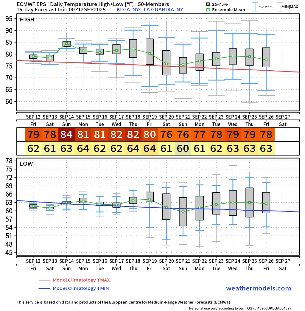
Looks like low 80s on EPS, regardless it’s above normal.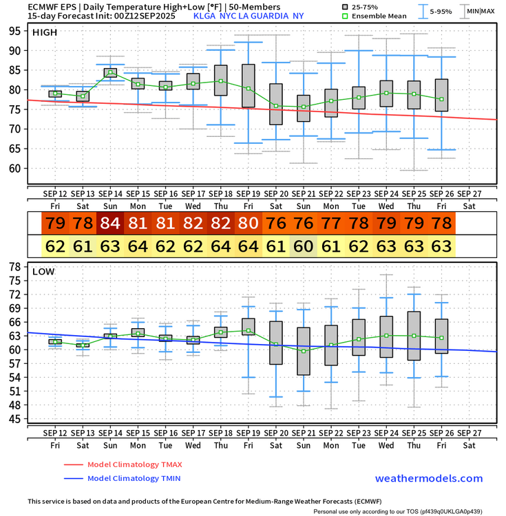
-
September 2025 OBS-Discussion centered NYC subforum
uofmiami replied to wdrag's topic in New York City Metro
48.6 in Muttontown & 50.6 in Syosset this morning. -
September 2025 OBS-Discussion centered NYC subforum
uofmiami replied to wdrag's topic in New York City Metro
49.1 in Muttontown & 51.4 in Syosset this morning. -
September 2025 OBS-Discussion centered NYC subforum
uofmiami replied to wdrag's topic in New York City Metro
1.37” in Syosset & 1.14” in Muttontown for rainfall totals. -
September 2025 OBS-Discussion centered NYC subforum
uofmiami replied to wdrag's topic in New York City Metro
1.32” in Syosset & 1.10” in Muttontown so far. -
September 2025 OBS-Discussion centered NYC subforum
uofmiami replied to wdrag's topic in New York City Metro
So much for the models having nothing for Suffolk GFS is looking good