uofmiami
-
Posts
2,304 -
Joined
-
Last visited
Content Type
Profiles
Blogs
Forums
American Weather
Media Demo
Store
Gallery
Everything posted by uofmiami
-
September 2025 OBS-Discussion centered NYC subforum
uofmiami replied to wdrag's topic in New York City Metro
1.32” in Syosset & 1.10” in Muttontown so far. -
September 2025 OBS-Discussion centered NYC subforum
uofmiami replied to wdrag's topic in New York City Metro
So much for the models having nothing for Suffolk GFS is looking good -
September 2025 OBS-Discussion centered NYC subforum
uofmiami replied to wdrag's topic in New York City Metro
-
September 2025 OBS-Discussion centered NYC subforum
uofmiami replied to wdrag's topic in New York City Metro
Radar seems to indicate metro on east is best for the additional rains this evening. -
September 2025 OBS-Discussion centered NYC subforum
uofmiami replied to wdrag's topic in New York City Metro
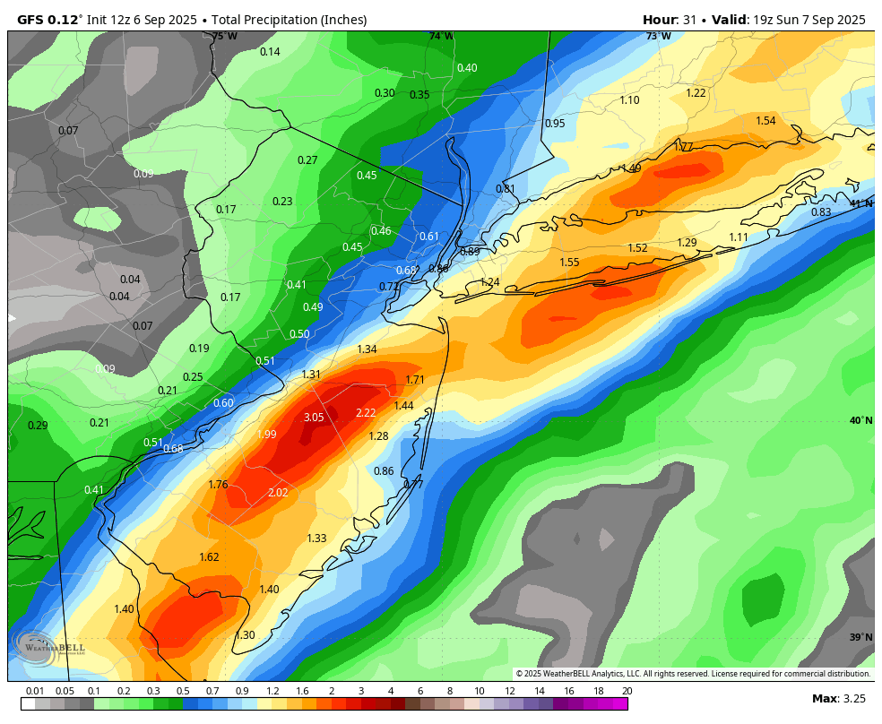
GFS has you covered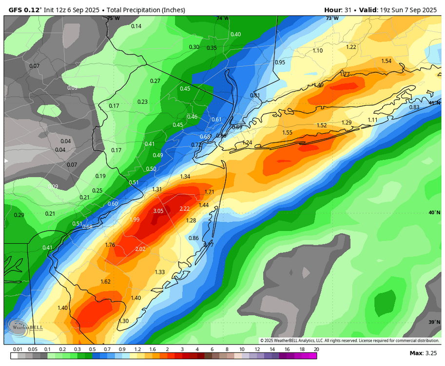
-
51.5 in Muttontown & 52.0 in Syosset this morning. 80.7 for the low here in Bermuda.
-
81.7 in Muttontown & 81.1 in Syosset
-
0.23" at both my stations so far & both currently 64.7
-
Wildfire smoke
-
No surprise, Euro didn't bite & only the AI EURO did for a run.
-
88.4 in Muttontown & 87.9 in Syosset for the high.
-
87.7 in Muttontown & 87.2 in Syosset today.
-
0.43” in Muttontown & 0.57” in Syosset
-
88.5 in Muttontown & 88.3 in Syosset for the high.
-
89.3 in Muttontown & 88.6 in Syosset for the high.
-
89.4 in Muttontown & 89.0 in Syosset for the high.
-
Erica? Isn’t the next named system Erin in the Atlantic.
-
89.0 in Muttontown and 88.4 in Syosset for the highs. Not much above forecast this morning which was 87, as I recall.
-
Doesn’t feel bad outside yet. DP still in the 50s. Probably had the last morning low in the 50s for a while though, 58 in Syosset and 59 in Muttontown.
-
53 in Muttontown & 54 in Syosset this morning.
-
54 in Muttontown & 55 in Syosset this morning.
-
https://nypost.com/2025/08/04/science/mysterious-underground-blob-of-superhot-rock-moving-toward-nyc/