uofmiami
-
Posts
2,304 -
Joined
-
Last visited
Content Type
Profiles
Blogs
Forums
American Weather
Media Demo
Store
Gallery
Everything posted by uofmiami
-
Cool off in the water already, lol
-
July 2025 Discussion-OBS - seasonable summer variability
uofmiami replied to wdrag's topic in New York City Metro
-
-
Passed out from the heat
-
You can put 100 up for LGA with the 5pm observation.
-
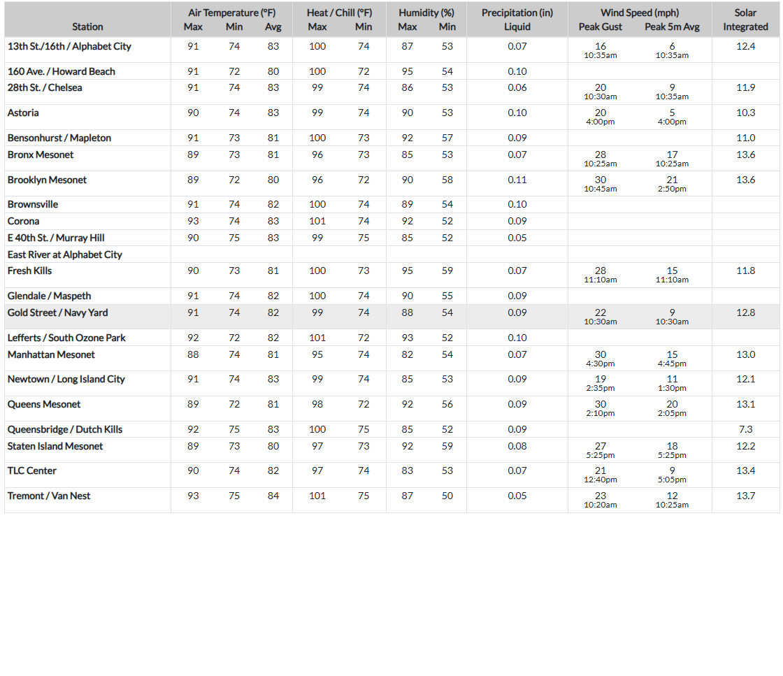
New York City Metropolitan Area Weather Roundup National Weather Service New York NY 500 PM EDT TUE JUN 24 2025 CITY SKY/WX TMP DP RH WIND PRES REMARKS Central Park MOSUNNY 95 64 35 W7 30.05F HX 97 LaGuardia Arpt MOSUNNY 100 58 24 W13G24 30.01F HX 99 Kennedy Intl MOSUNNY 102 62 26 NW14G22 30.02F HX 104 Newark Liberty MOSUNNY 102 63 27 W14G20 30.02F HX 104 Teterboro Arpt SUNNY 99 67 35 MISG 30.01F HX 103 Bronx Lehman C N/A 100 63 28 W10 N/A HX 102 Queens College N/A 100 59 25 NW16 N/A HX 100 Breezy Point N/A N/A N/A N/A SW5 N/A Brooklyn Coll N/A 99 63 30 W10 N/A HX 100 Staten Island N/A 100 64 30 W14 N/A HX 103
-
98.5 (Muttontown) & 98.3 (Syosset) for the highs today.
-
-
Don't you get acclimated to it? I did after a couple of years in S FL for college.
-
You have to wonder how some stations are sited, as well as the type of station too. I'm sure they'll be one somewhere touching 110 if you watch the map long enough, LOL. 96 at both of my stations now.
-
My Muttontown touched 96 & I am sure my Syosset station will get to 96. It's a slow climb with the NW winds along N Shore compared to S Shore, which is baking.
-
105 in Glen Head
-
95 currently at both my stations. Driving before noon from Syosset to Great Neck was interesting, as temps went from 93 to 102 by Flower Hill to 98 in Great Neck.
-
https://nysmesonet.org/networks/nyc Go to map view and zoom in. The list has some intersections, see below:

-
93.9 & 93.5 for the high at my stations.
-
Finally upgraded to extreme heat warning for tomorrow as I expected: URGENT - WEATHER MESSAGE National Weather Service New York NY 310 PM EDT Mon Jun 23 2025 CTZ011-NYZ078-080-177-179-241000- /O.EXB.KOKX.XH.W.0001.250624T1000Z-250625T0000Z/ /O.EXT.KOKX.HT.Y.0002.000000T0000Z-250624T1000Z/ Southern Middlesex-Northwest Suffolk-Southwest Suffolk-Northern Nassau-Southern Nassau- 310 PM EDT Mon Jun 23 2025 ...HEAT ADVISORY NOW IN EFFECT UNTIL 6 AM EDT TUESDAY... ...EXTREME HEAT WARNING IN EFFECT FROM 6 AM TO 8 PM EDT TUESDAY... * WHAT...For the Heat Advisory, heat index values up to 103. For the Extreme Heat Warning, dangerously hot conditions with heat index values up to 106 expected. * WHERE...In Connecticut, Southern Middlesex County. In New York, Northern Nassau, Northwest Suffolk, Southern Nassau, and Southwest Suffolk Counties. * WHEN...For the Heat Advisory, until 6 AM EDT Tuesday. For the Extreme Heat Warning, from 6 AM to 8 PM EDT Tuesday.
-
One zone for the whole house? Good luck, hope it doesn't go out on you. I replaced my A/C system back in 2018 when we moved into our house, as I didn't want the stress of my kids (2 y/o & newborn then) with no A/C on a hot day.
-
Correct: Regional Weather Roundup National Weather Service New York NY 1100 AM EDT MON JUN 23 2025 Note: "FAIR" indicates few or no clouds below 12,000 feet with no significant weather and/or obstructions to visibility. NYZ071-072-176-178-NJZ106-104-231600- New York City Metro Area CITY SKY/WX TMP DP RH WIND PRES REMARKS Central Park SUNNY 91 72 53 NE3 30.11F HX 98 World Trd Ctr NOT AVBL Bronx Lehman C N/A 91 73 55 NW3 N/A HX 100 LaGuardia Arpt MOSUNNY 91 73 55 NE5 30.07S HX 99 Queens College N/A 90 75 62 S7 N/A HX 100 Kennedy Intl MOSUNNY 89 78 70 S9 30.09S HX 103 Breezy Point N/A N/A N/A N/A S5 N/A Brooklyn Coll N/A 90 73 58 S5 N/A HX 98 Staten Island N/A 91 72 52 NW7 N/A HX 98 Newark/Liberty MOSUNNY 95 72 47 N3 30.08S HX 103 Teterboro SUNNY 92 75 57 VRB3 30.07S HX 103
-
5 degree bust for me in the point & click. 93 and only got to 88.
-
88 in Syosset & 87.8 in Muttontown for the high.
-
Looks like clearing coming down CT almost near coastline per WeatherTAP satellite loop. We should be sunny by noon along the coast.
-
If the tree canopy couldn’t succeed, the rain has come to help out.
-
WW3 lol
-
87.7 & 87.4 for the high temp at my stations today.
-
I'm sure Monday it'll be extended for Tuesday's heat.