uofmiami
-
Posts
2,299 -
Joined
-
Last visited
Content Type
Profiles
Blogs
Forums
American Weather
Media Demo
Store
Gallery
Everything posted by uofmiami
-
1” in Syosset
-
Storm potential January 17th-18th
uofmiami replied to WeatherGeek2025's topic in New York City Metro
Winter of when it can snow, it will snow, continues. Dumping in Great Neck with roads, etc. snow covered. -
Storm potential January 17th-18th
uofmiami replied to WeatherGeek2025's topic in New York City Metro
Out of time for what? -
43.4 in Muttontown & 43.8 in Syosset, about 3.5 miles apart.
-
Luck you, dropped from 44 this morning to 37 this afternoon.
-
40.1 & 40.2 at my stations, haha.
-
Is that for all major reporting stations or just ISP, which was the warmest of all stations last month? Every major was around -5 to -6 for the month, ISP was only -2.8.
-
It’s in the December thread:
-
Feels like one of those rare winters were it just wants to snow when it can. No complaints from me about it, especially after the last 2 winters we had.
-
Great, Webb posted this yesterday on X:
-
I didn't marry her, LOL! I concur, young & dumb back then.
-
I was there for that ball drop, they did an amazing job clearing the snow out. It was cold as hell and something I’ll never do again. Flew back from FL leaving family behind to be with my then gf, had to fly out a day ahead due to the storm but made it back to NY ahead of it.
-
City was cold this evening with the wind. Heading back now and the wind through the streets was biting. Only hit 48 with some snow spots left.
-
WWA issued finally for coastal zones URGENT - WINTER WEATHER MESSAGE National Weather Service New York NY 437 PM EST Sun Dec 28 2025 CTZ010>012-NJZ006-NYZ072-074-075-078>081-176>179-290300- /O.CON.KOKX.WW.Y.0014.251228T2200Z-251229T0300Z/ Southern New Haven-Southern Middlesex-Southern New London-Hudson- New York (Manhattan)-Richmond (Staten Island)-Kings (Brooklyn)- Northwest Suffolk-Northeast Suffolk-Southwest Suffolk-Southeast Suffolk-Northern Queens-Northern Nassau-Southern Queens-Southern Nassau- 437 PM EST Sun Dec 28 2025 ...WINTER WEATHER ADVISORY REMAINS IN EFFECT UNTIL 10 PM EST THIS EVENING... * WHAT...Light freezing rain or freezing drizzle expected. Total ice accumulations around a light glaze. * WHERE...Portions of southern Connecticut, northeast New Jersey, and southeast New York. * WHEN...Until 10 PM EST this evening. * IMPACTS...Very slippery sidewalks, roads and bridges are possible. * ADDITIONAL DETAILS...Surface temperatures should rise above freezing by late this evening allowing any precip to change to plain rain.
-
Of course we will & after a few hours go above freezing. OKX will SPS us instead of the WWA.
-
-
-
4.6” just measured and submitted to NWS. 12.2” for the month, can’t complain one bit.
-
Agreed on those teams (JMU & Tulane) making it. Good luck getting CFP changing it but they should. ND & BYU should have been in over them. Looking forward to next year up North.
-
If they only beat The U, lol.
-
Dog's name isn't Jeb, is it?
-
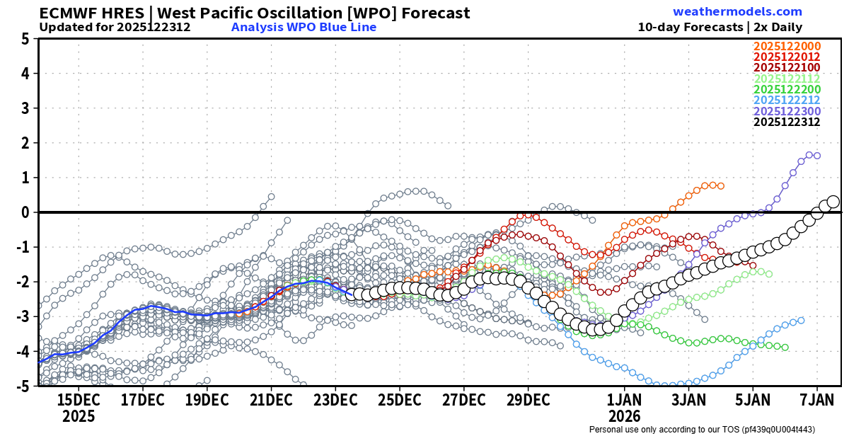
I think the -wpo didn't help
-
Warmth stayed S&W, no surprise. So much for the Scand block linking up with the SE ridge for a blowtorch over us as it transitioned to a -NAO. Got a quick warm shot the 18th & 19th, similar to late November instead. Looks like -5 departure from normal for the month.
-
Flipped to rain around 11:30. Temp still under 35 currently but snow was done accumulating due to weak rates.
-
Another .3" in Syosset, .6" so far on the snowboard. 33 & still snowing.