uofmiami
-
Posts
2,299 -
Joined
-
Last visited
Content Type
Profiles
Blogs
Forums
American Weather
Media Demo
Store
Gallery
Everything posted by uofmiami
-
I’m sure everyone will show up just before the show later, if not at home watching the Knicks game. Water isn’t warm enough and with no sun out it’s not desirable to head to the shore currently.
-
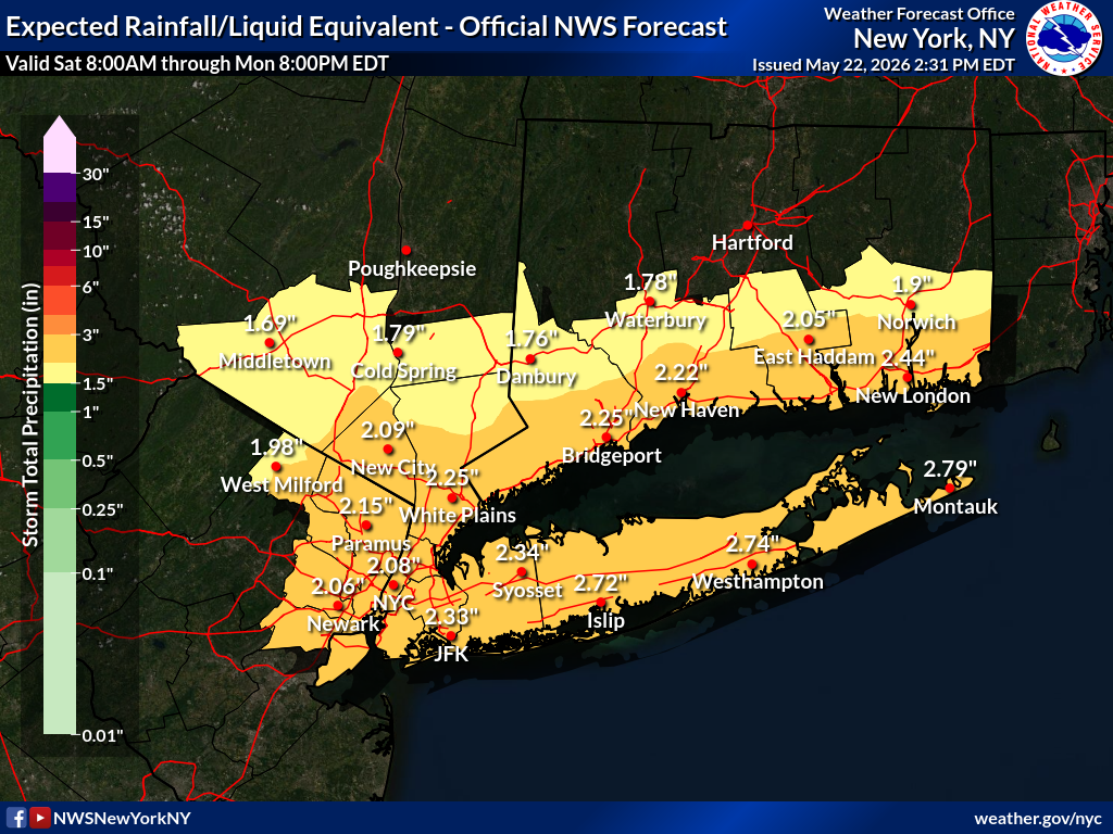
2.38” total in Syosset.
-
2.37” in Syosset & raining currently.
-
Up to 1.72" in Syosset currently.
-
1.30” in Syosset so far.
-
0.51” so far in Syosset.
-
Interesting stat
-
92.7 in Muttontown & 92.2 in Syosset for the high today. Cell popped over Glen Cove & another appears just N of FRG.
-
Cooking at JFK upon landing. 92 at my stations with DP of 63, not bad at all out there.
-
-51F at 35k feet. @nycwinter hoodie weather. Should beat any wx into NYC terminal.
-
91.2 in Muttontown & 90.3 in Syosset for the high today.
-
88.5 in Muttontown & 87.9 in Syosset today for the high.
-
87.9 & 87.3 back home for Muttontown & Syosset for highs today.
-
90 in Orlando w/DP of 68 currently. Summer weather down here. Bringing the heat back with me the middle of the week.
-
Gusted to 33mph in Syosset & 32mph in Muttontown so far.
-
Muggy? DP low to mid 50s
-
It sure as heck isn’t great for outdoor activities. Currently at an intramural baseball game. Feels like early March in late April. Hopefully the travel doubleheader is canceled for later due to rain.
- 970 replies
-
- 2
-

-

-
- april showers bring may..
- rain
- (and 2 more)
-
Saturday is going to be a nasty day. Thankfully Savannah bananas moved Saturday night game to tomorrow night.
-
Deep nap. They are out there flying around once the sun is out.
-
I’m suppose to go Saturday night. Hope weather improves for the weekend.
- 970 replies
-
- 2
-
-
- april showers bring may..
- rain
- (and 2 more)
-
27.3 (Muttontown) & 30.9 (Syosset) for morning lows.
- 970 replies
-
- 1
-
-
- april showers bring may..
- rain
- (and 2 more)
-
30.5 & 31.2 with frost at my stations this morning.