Nomz
-
Posts
705 -
Joined
-
Last visited
Content Type
Profiles
Blogs
Forums
American Weather
Media Demo
Store
Gallery
Everything posted by Nomz
-
January 24-26: Miracle or Mirage JV/Banter Thread!
Nomz replied to SnowenOutThere's topic in Mid Atlantic
How’s it looking? Haven’t had time to weather nerd today and last night. -
January 24-26: Miracle or Mirage JV/Banter Thread!
Nomz replied to SnowenOutThere's topic in Mid Atlantic
I’m unfortunately going to be doing some I Told You So -
Seeing clouds with the arctic blast overspreading the blue ridge from 81
-
AIFS has been deadly this winter so I'll take it in our corner
-
January 24-26: Miracle or Mirage JV/Banter Thread!
Nomz replied to SnowenOutThere's topic in Mid Atlantic
If we get a sequel event next week, I'm not staying up to see the 00z euro till we're at least within 72 hours. -
January 24-26: Miracle or Mirage JV/Banter Thread!
Nomz replied to SnowenOutThere's topic in Mid Atlantic
I think you already screwed us lol -
January 24-26: Miracle or Mirage JV/Banter Thread!
Nomz replied to SnowenOutThere's topic in Mid Atlantic
Winter storm warnings from Mexico to Boston. Anyways Georgetown just cancelled for the poor saps that have classes Sunday.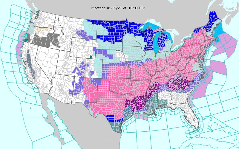
-
January 24-26: Miracle or Mirage JV/Banter Thread!
Nomz replied to SnowenOutThere's topic in Mid Atlantic
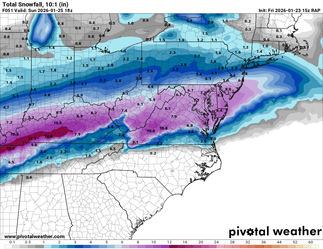
I was just looking at the 10:1 snow map and it looked off up north and figured it would have upstream effects. -
Jan 24-26 Weekend Snow and Sleetfest Model Thread Part Tres
Nomz replied to H2O's topic in Mid Atlantic
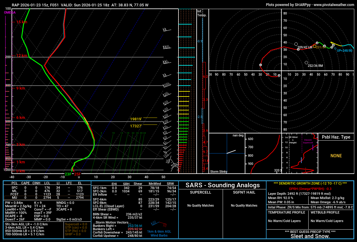
No clue how good the RAP is with winter wx, but I like it more than the NAM for severe wx. Gives us 7.7 inches on 10:1 at the end of the model run and coincidentally right before the changeover

-
January 24-26: Miracle or Mirage JV/Banter Thread!
Nomz replied to SnowenOutThere's topic in Mid Atlantic
when green line go past blue line bad -
Jan 24-26 Weekend Snow and Sleetfest Model Thread Part Tres
Nomz replied to H2O's topic in Mid Atlantic
Probably a ratio thing then... lucky fucks up north probably getting 15+:1 -
AIFS has something at like h300 but its a miller b
-
Jan 24-26 Weekend Snow and Sleetfest Model Thread Part Tres
Nomz replied to H2O's topic in Mid Atlantic
Euro seems unusually dry. Even places up north like BOX and ALY only see just over 10 inches on 10:1. -
January 24-26: Miracle or Mirage JV/Banter Thread!
Nomz replied to SnowenOutThere's topic in Mid Atlantic
Making hot chocolate again. Are we still cliff diving? -
January 24-26: Miracle or Mirage JV/Banter Thread!
Nomz replied to SnowenOutThere's topic in Mid Atlantic
Are ratios solely based on surface temps, assuming there isn’t an above freezing warm nose? -
January 24-26: Miracle or Mirage JV/Banter Thread!
Nomz replied to SnowenOutThere's topic in Mid Atlantic
Bit of a culture shock for me man. 6-10 of snow and sleet Sunday AM would have an outside shot of getting us out of Monday. -
January 24-26: Miracle or Mirage JV/Banter Thread!
Nomz replied to SnowenOutThere's topic in Mid Atlantic
Meanwhile I’m having to argue with people who expect 1+ because Apple Weather is the worst app ever created. It feels like a psyop to destroy trust in meteorology. -
January 24-26: Miracle or Mirage JV/Banter Thread!
Nomz replied to SnowenOutThere's topic in Mid Atlantic
However, I did see someone who was way in over their head take the h288 GFS from 12z yesterday verbatim (the one that showed like 40" in DC) so maybe we're not ready for that -
January 24-26: Miracle or Mirage JV/Banter Thread!
Nomz replied to SnowenOutThere's topic in Mid Atlantic
I had the same question and didn't get any answers. I don't think a single model has been close to 24" since Tuesday. I think I could chatGPT an app that produces better precip forecasts than apple weather. -
January 24-26: Miracle or Mirage JV/Banter Thread!
Nomz replied to SnowenOutThere's topic in Mid Atlantic
Went from this on Wednesday To this today (DC)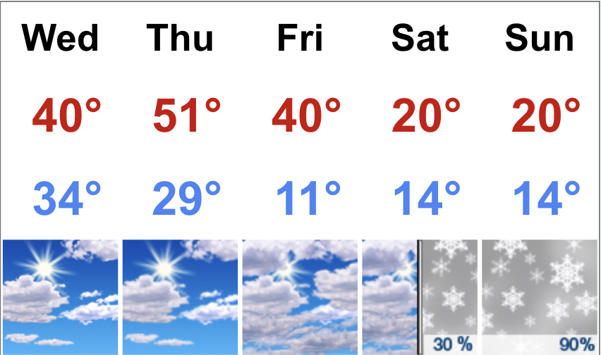
-
January 24-26: Miracle or Mirage JV/Banter Thread!
Nomz replied to SnowenOutThere's topic in Mid Atlantic
Totally meaningless, but it has been depressing to watch the Saturday and Sunday night low temps creep up like 3 degrees. -
Like I said, the “Expected Total: Official NWS Forecast” map is 100% computer generated. I think it runs every 10 min, iirc it was :02, :12 up in NWS BOX.
-
January 24-26: Miracle or Mirage JV/Banter Thread!
Nomz replied to SnowenOutThere's topic in Mid Atlantic
For sure the 00z suite was a small win, but people are really searching for a huge shift south to recover all our losses. It’s like gambling to cover loses. -
The more agressive map is the one in the “Local Winter Key Messages” while the other one is the autogenerated “Day 0-3 Snow and Range of Possibilities.” Usually the Key Messages one is more conservative and more accurate though, so I’m not sure what’s going on.
-
January 24-26: Miracle or Mirage JV/Banter Thread!
Nomz replied to SnowenOutThere's topic in Mid Atlantic
Boston also salts heavily, although recently we've probably rationed our supply better (also there hasn't been much winter precip) since 2015 when we nearly ran out of salt and sand. If you've ever driven up to where 95 meets 128, you'll see one of the massive salt warehouses.