
.jpeg.ee54af147b498e279581e1a7251c11d3.jpeg)
Baum
-
Posts
4,013 -
Joined
-
Last visited
Content Type
Profiles
Blogs
Forums
American Weather
Media Demo
Store
Gallery
Posts posted by Baum
-
-
Just now, hlcater said:
It's been a long time since I've seen this.
november 25
-
good to see some positivity creep back into the board
-
 1
1
-
-
18 hours ago, AppsRunner said:
There’s a decent chance that central Iowa barely gets advisory criteria snow. These trends don’t look ideal.
So maybe this will turn about better than originally thought
-
9 minutes ago, BeastFromTheEast said:
First flakes. -SN here in Hoffman Estates
same here.
-
2 minutes ago, Chicago Storm said:
70/30 shot it under-performs.
Most likely. Most times to me these storms underperform given all the complexities that go into them which is why I didn't bite big time on a super storm as many alluded to last Sunday when this thread was started. That said, I wouldn't be surprised to grab 4" overnight and another 2" of lake effect saturday night for 6" of fresh powder.
-
9 minutes ago, SchaumburgStormer said:
Red flags coming from about every direction to lower expectations locally.
nah. Go outside...it even smells like snow.
-
 1
1
-
1
-
-
5 minutes ago, RyanDe680 said:
No one has really talked ratios. I would think that based on temps, moisture, etc., 10 to 1 seems good?
i would expect a bit better than that.
-
That would be 6".I don’t think Glen Ellyn sees 6-10” with recent trends in the FGEN. Think it’ll be closer to 4-6” all in, LE included.
I can see storm total of 6-10” by the lake where the band sets up. Even Milwaukee in line to get 6-10” if you ask me, all in.
Personally I wish I was a bit further north (maybe Waukegan area), but I still like where I am, right on the lake.
Sent from my SM-G960U using Tapatalk
-
3 minutes ago, mimillman said:
That’s a nice LE signal on the NAM there, very slow to rotate east. Someone in NE IL could see a lucky 6” from the lake effect alone, methinks
Forecasted 6-10" in these parts seems like we have several ways to get there one way or another. Anybody in line to get FGEN band and the synoptic snows?
-
1
-
-
3 minutes ago, CoalCityWxMan said:
NAM centers it around the I-88 corridor while the hrrr/rap has it further north. Would hate to be LOT tonight, tough call.
no changes....easy
new afd states this. Perhaps a 1/2 county shift south.
-
The reality always is folks want to trust the solutions they want and discount the solutions they don't. Always been that way. Will still be a decent winter event just won't be similar to that early February storm from several years back. And, I never expected that. Perspective.
-
1
-
-
2 minutes ago, UMB WX said:
Sub forums will be hopping after that NAM run. JI back in the game

so glad were not part of that east coast/mid Atlantic clown show
-
1
-
 1
1
-
1
-
-
1 minute ago, Frog Town said:
I'm getting the same vibes I got last night as the 0Z suite rolled in. I"m sensing a pattern here. Best cure for the is a strong Double IPA(NOT a Computer model for those of you wandering) and Bed. See you Weenies in the morning.
smartest guy in the room.
-
1
-
2
-
-
Just now, Hoosier said:
That being said, still going to be a very nice run for Chicago area.
your on the hook for 4" at my place.

-
2 minutes ago, AppsRunner said:
You aren’t wrong, but even then most globals and other high res guidance has been putting a nice gradient down somewhere in west central Iowa. Even then I don’t feel great about widespread warning criteria snow. Something about this storm just doesn’t feel right to me.
I needed you to say that 48 hrs ago before you got me invested.
-
2 minutes ago, AppsRunner said:
HRRR/RAP/RGEM trends have been extremely unfavorable. Or I could just be sleep deprived after a week of regular work and tracking this in my spare time, but I don’t feel good about this at all
ok. short term model trends. Your the pro so I'll trust your insight. Would be a dramatic change based on some of the maps i've seen.
-
11 minutes ago, AppsRunner said:
There’s a decent chance that central Iowa barely gets advisory criteria snow. These trends don’t look ideal.
based on what?
-
23 minutes ago, ChiTownSnow said:
I'm hesitant for Chicago. I don't like relying on fgen band and/or lake effect. Both may or may not happen and are much less reliable to forecast..Tricky forecast for sure
glass half full.
-
1
-
-
Just now, ChiTownSnow said:
What???. Where did this come from
Right from Hoosiers lips....that's with the lake effect totals...be nice to verify.
-
1
-
-
2 minutes ago, whoosh said:
your golden. Take the dog for a walk during it's peak.
-
1
-
2
-
-
1 minute ago, mimillman said:
Didn’t you literally just get a good storm dude
People in this thread want every storm. Last week was 6 days ago.
-
1
-
1
-
3
-
-
2 minutes ago, Chambana said:
Do you see the fgen band as far south as Champaign?
Extreme N Ill. Southern Wisconsin,Extreme Southern Mich and N. Indiana.
-
3 minutes ago, AppsRunner said:
Didn't see it mentioned but the GFS was basically a drier, slightly south version of the NAM.
I guess that's somewhat of a consensus.....
-
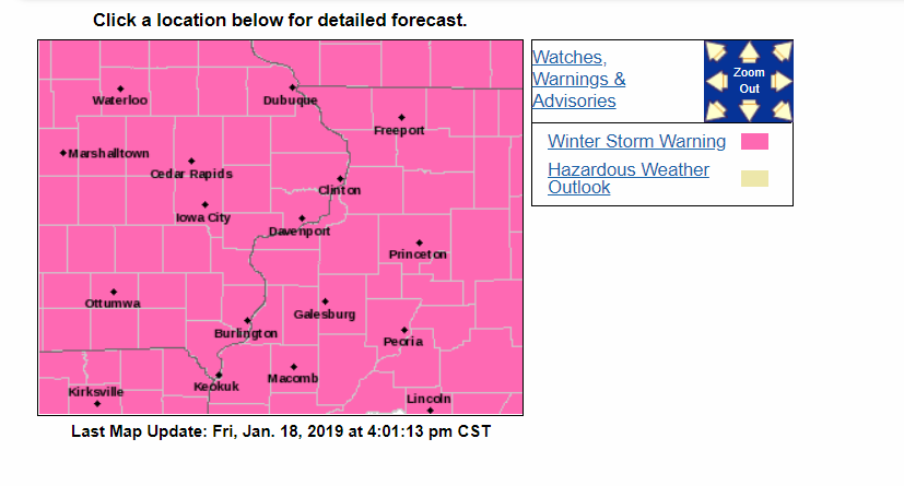
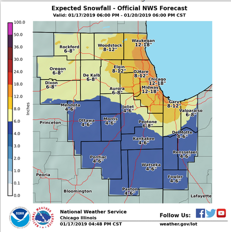
Caveat:"locally heavier totals possible."They go with 4-8” ending Saturday morning. So this is not including lake effect possibilities.
Wonder if they’ll issue or extend headlines for this.
Sent from my SM-G960U using Tapatalk
Winter Storm? Jan 18-19th, 2019
in Lakes/Ohio Valley
Posted
that's quite the change from earlier reports