-
Posts
4,013 -
Joined
-
Last visited
Content Type
Profiles
Blogs
Forums
American Weather
Media Demo
Store
Gallery
Posts posted by Baum
-
-
What's been interesting over the past several days is that LOT has not done much model analysis rather opting for more a feel of the synoptic set up and perhaps a historical approach to how these things can play out to derive the event potential. In short, I don't think I've seen any consternation on their part with regards to the more sheared southern look of the globals versus the more amped approach of the hi-res models. Refreshing approach IMHO.
-
 3
3
-
-
1 minute ago, mimillman said:
I agree the FGEN placement is key for areas north and would me the difference between 2” and 5”, maybe slightly more locally. Hoping for anything else is not prudent.
I almost consider the lake effect a different event considering it will be happening 12+ hours later and I’m not sure how LOT handles that. Perhaps WWA to lake effect snow advisory?
2-5" on the FGEN band is conservative. Read the AFD. Pretty clear they are thinking Watch to a Warning in your neck of the woods. Though I'm long past getting caught up in the NWS designations. Today's 12Z runs will dictate that. Though NE IL looks pretty decent even with the fractured nature of this system.
-
1 minute ago, mimillman said:
I’m thinking more 2-5” from synoptic snows, but I could see the lake effect pushing us over 6 if we get lucky.
key will be where that frontogentic band takes up residence. btw....you could be in line for 6" just from lake effect. Alot of potential if it could be relaized.
-
10 minutes ago, mimillman said:
3z SREF came in weaker. I don’t think this is happening. Too much consensus from the globals and too much known amped bias from the hi res.
I like LOT's read on this. Even in a discombobulated manner your in line for in excess of 6". And of course still the possibility exists all factors come together for a doozy...though that is appearing less likely.
-
 1
1
-
-
Quad Cities afternoon afd is a fun read for winter weather aficionados. Nothing in depth just cold and snow for the foreseeable future.
-
2 minutes ago, mimillman said:
I don’t recall seeing any LE headlines in Cook for a couple years. Wonder if this weekend changes that.
March 2017 I believe. But that was a straight LE event unlike this one which will be synoptic transferring to lake event
-
7 minutes ago, mimillman said:
It’s been an abysmal winter up to this point. Take it.
by march 15th you'll be begging for spring....
-
25 minutes ago, King James said:
Woke up to read the LOT AFD, definitely a different tone today.
.I thought it was another fine job of laying out the possibilities, while clearly stating there is still much uncertainty. As there is with any weather event. The tone has always been cautious....as it should be.
-
 1
1
-
-
It's typical to see at least one model hold sway as to what you think might happen. When they all trend in the same direction,despite lack of sampling it's an ominous sign. Could be as Cyclone said a case of delayed, but not denied. Plenty of ingredients in the mix.
-
Per usual RC with a fine AFD at LOT. Won't post, but well worth the read for most.
-
 5
5
-
-
3 minutes ago, Angrysummons said:
Well, it may not develop and end up a ho hum wave. 50/50 shot.
now I feel better.
-
 1
1
-
 1
1
-
-
8 minutes ago, Angrysummons said:
I would put this energy vortex right up against Super Bowl, GHD and the 1999 storms in terms of Great Lakes snowfall/wind potential. You just look at that vortex off the pacific your like wow!!!! What a high priced texas hooker.
your never positive. Game Ovah!
-
 2
2
-
-
On 1/14/2019 at 9:59 AM, Chicago Storm said:
I'm intrigued about this period...but there are some fail points.
The first potential issue is if that lead wave on Wed/Thur continues to show up in a more organized way, which could lead to a less favorable environment (such as lower heights) for this main system to follow. The second potential issue would be lesser phasing or a total missed phase between the northern and southern stream waves for this main system. The third potential issue would be how far north/south the southern wave comes through the West. The final potential issue would the placement of the PV over Canada, and if it ends up further north or south.
So while I can see a big dog happening with 12"+ amounts somewhere, I could also see a weaker/unorganized system way south as well.
Edit: Another issue is also placement on northern stream, coming around the PV.
perspective. Though I know I'm good for 4 inches per Hoosier....

-
 1
1
-
-
5 minutes ago, StormChaser4Life said:
I guess I should say multiple vorts involved instead. Just isn't looking like a slam dunk winter storm. A lot has to time right and position right. Also need to see if this thurs system is weak or amped. Not saying we won't see a major winter storm, just more complications than the last one. Not as clear cut
there is no such thing as a slam dunk winter storm. That said, you've got a lot of key players on the field as we enter a dramatic pattern change. Percentages are decent of a fairly widespread moderate to high end event impacting a good chunk of this forum.
-
 1
1
-
-
25 minutes ago, StormChaser4Life said:
Typically these winter storms that require so many pieces to come together rarely pan out. Just so sensitive to the smallest of changes. So many PV's involved and that brutal high pressure. Honestly it is a crap shoot at this point. Feel like the high end p otential of this isn't super high but feel like a moderate event is more likely. Not discounting a powerhouse storm but atm I'm not feeling confident in that
whaadya mean? Yesterday it was a sure thing...I had a repeat already pegged of that February 2nd storm from several years back...but with stronger winds. Now it's complicated?

-
 2
2
-
-
1 minute ago, Hoosier said:
Nice to have the lake as a fallback option. I don't know if I've ever felt this good about 4+ this far out
kiss of death....
-
 1
1
-
-
Agreed.As the mayhem of placement starts to narrow I'm thinking +FZRN will dominate some ones forecast.
Sent from my SM-G960U using Tapatalk
-
way too much talk...way too soon. heartbreak typically follows....you'll excuse me if i don't buy in as the cody parkey therapy tour is still too fresh. That said...winter is coming with a vengeance...me thinks.
-
 1
1
-
-
3 minutes ago, Hoosier said:
That brings up an obvious point... that the amount of settling/compaction varies by storm. In some, the difference between measuring every hour, every 3 hours or every 6 hours may be trivial, but I'm just providing the official standard.
I'm not a trained spotter (though I did stay at a Holiday Inn last night) so if somebody wants to add or correct something, go ahead.
what a world....walk out your back door and stick a ruler in it. not complicated.
-
 4
4
-
 1
1
-
-
30 minutes ago, mimillman said:
Fighting some dry air now in these parts. I’m not worried, radar looks good.
Should continue to be a snowy night.
huh? its been snowing since 7 am....got about 3" down here. Thinking another inch to come minimum...
-
best rates of the event thus far. Perfect winter day.
-
 1
1
-
-
49 minutes ago, King James said:
Started snowing here in the 60954
.same out this way. sooner than expected. good trend, as I was worried about a shut out.
-
 1
1
-
-
6 minutes ago, KokomoWX said:
Dry air winning in Kokomo too. Just a dusting and nothing is falling right now. NWS already has trended down the morning forecast by a couple of inches.
zone for Kokomo called for 5-7" at 9:33pm last night. It calls for 6" on today's 3am issuance. maybe i'm missing something.
-
7 minutes ago, King James said:
Dry air still winning in Kankakee County. No flakes yet despite the radar returns
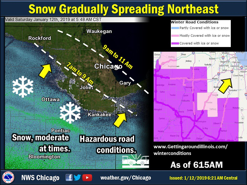
.yup. only saving grace maybe the slow movement of the storm which could eventually overcome the issue. Noticed LOT isn't expecting snow to commence until mid morning across my zones.


-
 1
1
-


.thumb.jpeg.56a9ebf712d5b807b01f737fdf2721c2.jpeg)
Winter Storm? Jan 18-19th, 2019
in Lakes/Ohio Valley
Posted
Sent from my SM-G960U using Tapatalk