Ericjcrash
-
Posts
5,529 -
Joined
-
Last visited
Content Type
Profiles
Blogs
Forums
American Weather
Media Demo
Store
Gallery
Everything posted by Ericjcrash
-
Upstate/Eastern New York
Ericjcrash replied to BuffaloWeather's topic in Upstate New York/Pennsylvania
That's reasonable. It has slowed down a bit though so big totals are on the table -
3k NAM is pretty close to a decent hit. Toasty, yes but still.
-
Upstate/Eastern New York
Ericjcrash replied to BuffaloWeather's topic in Upstate New York/Pennsylvania
Yeah, but it's because of extreme storms. Thursday NYC can get a foot and still go to rain/sleet. I feel like that's how its going to play out. -
Upstate/Eastern New York
Ericjcrash replied to BuffaloWeather's topic in Upstate New York/Pennsylvania
I'd much rather be in Sullivan county. This keeps ticking NW. I've lived the NYC nightmare many times...jackpotted 4 days out only to be pinging or raining watching a crushing on NW webcams -
Active mid December with multiple event potential
Ericjcrash replied to Typhoon Tip's topic in New England
Certainly can be. -
I'm under the impression that strong winds basically break up dendrites, could be wrong but that makes sense to my uneducated self.
- 3,762 replies
-
- 1
-

-
- heavy snow
- heavy rain
- (and 3 more)
-
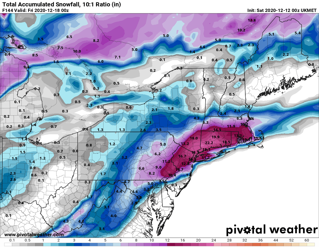
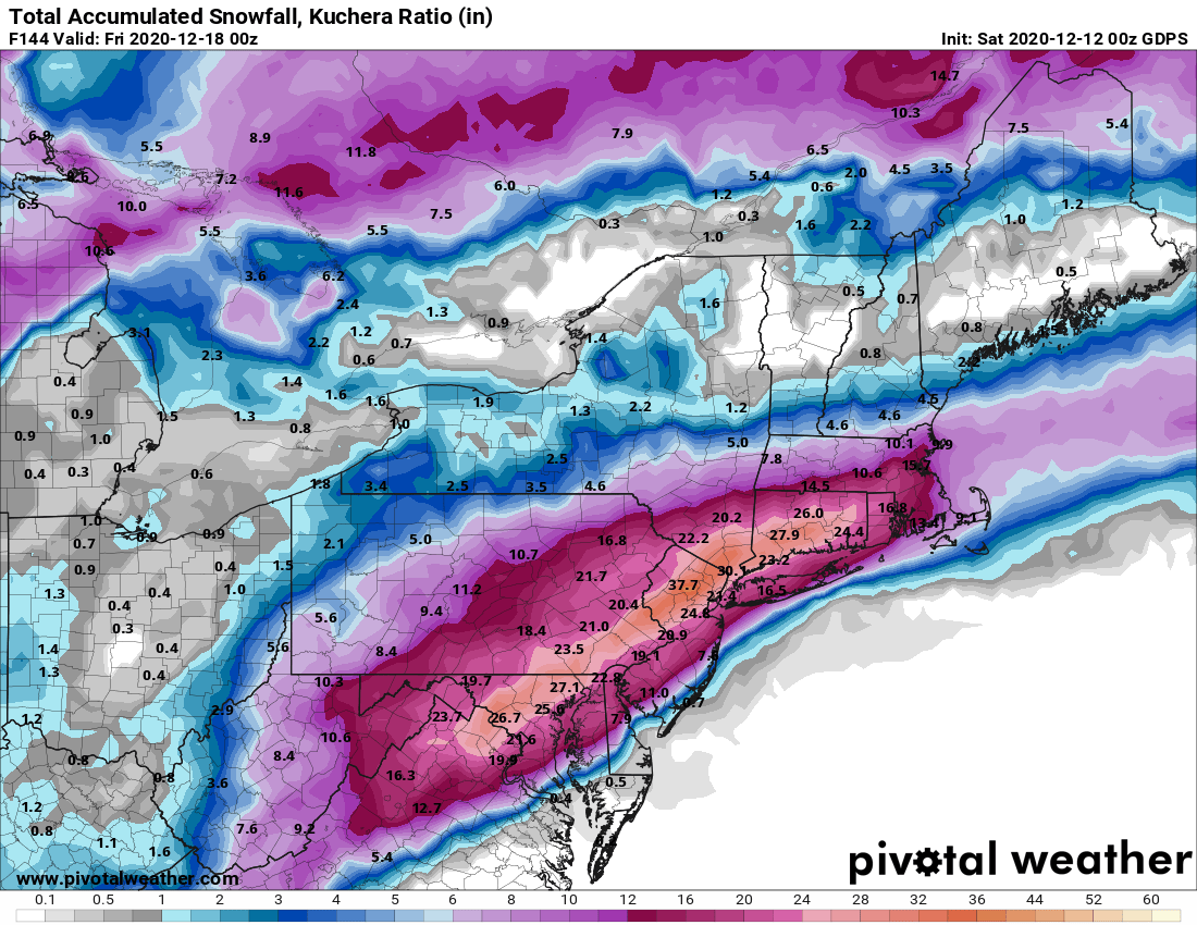
Its going to be hard to erode the cold at the surface for sure as that's often overstated but mid level warming is often underdone. Either way we're lucky to be tracking something with this much potential that even if it came NW most if not all cash in significantly regardless.
-
Upstate/Eastern New York
Ericjcrash replied to BuffaloWeather's topic in Upstate New York/Pennsylvania
Agreed, but honestly I'd be lying if I said I don't want it to verify. -
I'm starting to wonder if someone gets a decent sleetstorm if its tucked. Super cold airmass yes, but in the back of my head seeing the low pretty far SW I can see some pinging.
-
Yeah, if it can come NW a little somewhere like west Milford can cash in.
-
Upstate/Eastern New York
Ericjcrash replied to BuffaloWeather's topic in Upstate New York/Pennsylvania
I think that's what might end up happening, however with the airmass and high, the latter can come pretty far NW and still end up being a massive hit for NYC while letting us get the goods as well. -
Active mid December with multiple event potential
Ericjcrash replied to Typhoon Tip's topic in New England
Definitely more A, baby comes right on up the coast -
Yeah, its going to be pretty windy and that's always underplayed when people assume ratios.
- 3,762 replies
-
- 1
-
-
- heavy snow
- heavy rain
- (and 3 more)
-
Upstate/Eastern New York
Ericjcrash replied to BuffaloWeather's topic in Upstate New York/Pennsylvania
6z EPS individuals include a lot of sexy solutions. I like where I'm at honestly, I-95 folks can say confluence till they're blue in the face but we've all seen the NW ticks before. -
Big hit once again
-
No koooch but not needed.

-
Upstate/Eastern New York
Ericjcrash replied to BuffaloWeather's topic in Upstate New York/Pennsylvania
4 for 4 already on the 0z suite. -
Upstate/Eastern New York
Ericjcrash replied to BuffaloWeather's topic in Upstate New York/Pennsylvania
As one formerly, we just wait for the NW trend...it's coming. -
Being this far north, I can dig the lean. Airmass being so cold so can the coast.
-
Iirc like 17 or so
-
Active mid December with multiple event potential
Ericjcrash replied to Typhoon Tip's topic in New England
Only if it goes another 70-80 mi north. It should be a full house for the 0z run -
Active mid December with multiple event potential
Ericjcrash replied to Typhoon Tip's topic in New England
I have to now.
-
Upstate/Eastern New York
Ericjcrash replied to BuffaloWeather's topic in Upstate New York/Pennsylvania
Regardless it's going to get seriously cold late week.