

cleetussnow
-
Posts
2,084 -
Joined
-
Last visited
Content Type
Profiles
Blogs
Forums
American Weather
Media Demo
Store
Gallery
Posts posted by cleetussnow
-
-
-
-
2 minutes ago, MJO812 said:
Wow 10 weenies for this post.
I'm going to weenie everyone who gave me a weenie if this storm does come west.
Deal.
-
 1
1
-
-
16 minutes ago, MJO812 said:
DT expects the models to trend west this weekend .
Sorry to slap you with a weenie there, but it was warranted.
-
 1
1
-
 1
1
-
5
-
-
3 minutes ago, ILoveWinter said:
This much pessimism after a bad run by one model at 18z 4 days out from the event? Way too early for that! (or being overly optimistic for that matter)
It is more than 1 run of 1 model and a trend may be emerging but there is still a spread 4 days out, so too early to call it.
-
1
-
-
-
4 hours ago, snowman19 said:
The Euro is still the best model we have, especially given that it excels during southern branch dominated Ninos. I think that solution is absolutely believable given how fast the southern branch shortwave is moving and the incoming trough acts as a kicker making everything progressive. Everything gets pushed OTS. On the bright side for those who have been wanting cold, it does finally get truly arctic cold on 1/20 after a strong clipper FROPA, which has some snow with it. The Euro brings a piece of the TPV over us.
IMO ride the Euro like sea biscuit….
Ima save this post.
-
1
-
-
1 minute ago, Franklin0529 said:
Big?
Prolly lays down 10-12 or so, maybe more. One run but a good one
-
1
-
-
-
2 minutes ago, mannynyc said:

I deleted my post after that frame showed on ttb
-
1
-
-
17 minutes ago, WinterWolf said:
No seriously….it wasn’t as prolific as some think. The sleet killed it for a lot of us..too bad. About 16” here then pingers for hrs.
Op said not a lot of people maybe but a huge area did. I put a yardstick through it where I was. Official was lower there but still 2 feet upstate NY
-
 1
1
-
-
1 hour ago, dendrite said:
Not many had 2ft in that.
Bullshit.
-
1
-
1
-
-
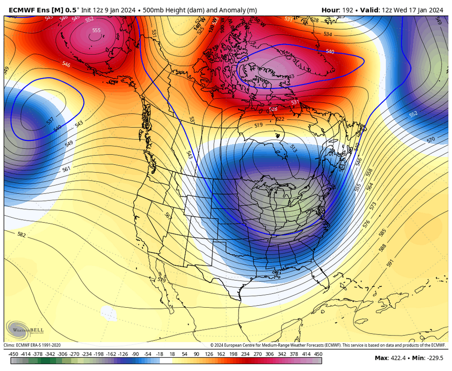
7 minutes ago, WestBabylonWeather said:
Models are speculating what they think in regards to how the cutter will change the pattern or what will happen. When models get data after the cutter it will be more up to date. I think
Adding to this: First, the cutter is a huge storm. Watch what it does on the GFS on tropical - hit PLAY on this map on the link and you can see in motion how the whole eastern half of the US is impacted by this thing.
GFS Model – 500mb Height & MSLP for CONUS | Tropical Tidbits
It ultimately acts as a 'gear' helping pull cold down in the eastern 1/3 of the US. Exactly HOW that low amplifies the pattern is whats at stake. A Met will chime in right now and correct me.
-
1
-
-
3 minutes ago, dendrite said:
OnlyBuns?
That is exactly where all of the weenies go.
-
1
-
-
-
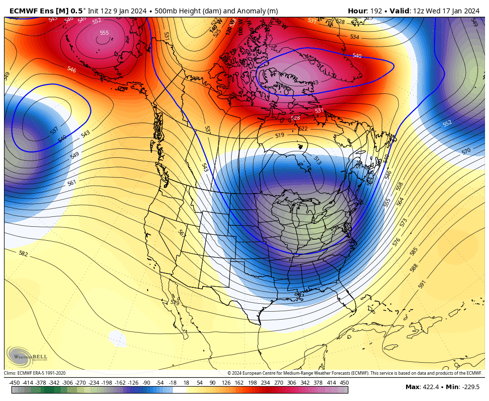
How's the 20-22nd looking on the Euro?
-
1
-
-
-
we don't want the PV sitting over our heads. Cold and DRY.
-
2
-
-
1 minute ago, Hazey said:
The day 4- 7 model period is getting annoying. I feel lately that that is the time frame when s/w's make big jumps around. Ensembles until day 3 at the earliest. Hopefully has a clue by day 2 but not always. Anyway good period coming up next week. Hopefully someone cashes in.
I think the 16th storm is going to be wobbly until after the cutter this weekend.
-
1
-
-
4 minutes ago, ORH_wxman said:
Yeah getting past 30" is always tough, though we managed to do it several times in the 2000-2015 period....March 2001 over the interior was the first one (1996 if we want to include a few years earlier), then we did it again in early Feb 2011, then we managed to do it again in March 2013 (but not on the coastal plain), then of course Feb 2015.
Years like Jan/Feb 2005 got "stuck" around 27-30", ditto 2007-08, Jan 2009, Feb 2014, Mar 2018, and we fell a little short of that number in Feb 2021 (more like 23-24" depth)
December 2020 interior, Binghamton add that. 4 feet OTG IIRC!
Pretty sure superstorm over the interior somewhere
-
1
-
-
6 minutes ago, DavisStraight said:
Love it when Tip has subsume in his posts. Usually means something good.
Yeah and a mention of the Super Storm. I bricked up reading it.
-
1
-
-
1 hour ago, Albedoman said:
Walt, if we can get a decent cutter to come across that polar air in the midwest and drag it over the Appalachians, we are in the game for some decent and memorable snowfall events after next Tuesday. Many posters either do not remember 96 or were not alive but I sure the hell do. It only takes one good cutter with a deep trough and an -NAO to phase LP's some good storms along the east coast. We just need some of that polar air to get the engine fine tuned. That polar air locked in the midwest and Ohio Valley IMHO next week transferring just a few days over to us by a clipper would be like putting is like putting Sea Foam in your V8 carburetor. LOL
I was thinking this. The cutters are change agents to a degree, and I don't know if it's the case, but perhaps the 2 cutters in a row are in tandem pattern drivers, not just the one coming up. I can see the cold load out west after the first one, and reload there and press east with the second one, so maybe that's a fact? Is that what's happening?
-
1
-
-
28 minutes ago, 40/70 Benchmark said:
I think our big doggie looms shortly thereafter, beyond the apex of the blocking...
Yeah I feel like that's what happens. We get a period of cold which delivers a couple of nickle and dimers and then a big dog. Perhaps this all goes down in the next 2-3 weeks. I'd sign on for that and take my chances the rest of winter and I'm sure a lot of people here would do so as well.
-
3
-
-
12 minutes ago, brooklynwx99 said:
i think it’s a really good pattern and people are a bit gun shy. if this pattern popped up in the medium range in 2014 everyone would be disrobing
Wait...we're not disrobing? Um ok...gimme a sec...
-
3
-

Potential extensive winter event, I-95 west and with again a chance for NYC first inch(es) of snow Mon or more likely Tue Jan 16, 2024 (serves as OBS thread as well)
in New York City Metro
Posted
PS signal for the 20th still there on GFS. So thats good.