

Powerball
-
Posts
14,471 -
Joined
-
Last visited
Content Type
Profiles
Blogs
Forums
American Weather
Media Demo
Store
Gallery
Everything posted by Powerball
-
Where are you getting the "Macomb" and "Monroe" numbers from? I'm assuming the Lake Orion and Wyandotte numbers are measurements from you and michsnowfreak...
-
18-20" of snow in STL? Easy toss....
-

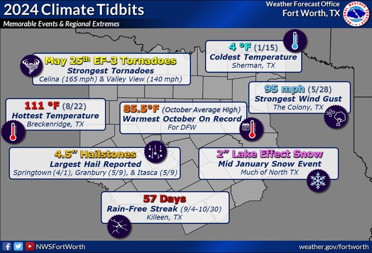
Texas 2024 Discussion/Observations
Powerball replied to Stx_Thunder's topic in Central/Western States
-
Lol...
-
Winter 2024-25 Medium/Long Range Discussion
Powerball replied to michsnowfreak's topic in Lakes/Ohio Valley
I'd love nothing more than to send all of the cold & snowstorm potential y'alls way this weekend and next week. The OK/TX folks can barely contain themselves over the model-depicted cold blast and snowstorm teases, and I hate to see it... -
Texas 2024 Discussion/Observations
Powerball replied to Stx_Thunder's topic in Central/Western States
Not only will this December be a top 3 warmest for DFW (surprising considering how milquetoast the month started and no real extreme warmth), it should also be good enough for DFW to tie the warmest yeard on record with average temperature of 69.8*F (the previous record was set in 2017). EDIT: Should also add: All top 5 of the warmest years on record will now have been since 2010 years (2024, 2017, 2023, 2016 and 2012). -
Texas 2024 Discussion/Observations
Powerball replied to Stx_Thunder's topic in Central/Western States
Today's high at DFW was 82*F officially, several degrees above the forecasted high. -
Texas 2024 Discussion/Observations
Powerball replied to Stx_Thunder's topic in Central/Western States
DFW may be on track for a top 10 warmest December this year. In addition, to-date, 2024 is currently tied with 2023 for the 2nd warmest year on record (69.7*F). For perspective, the warmest year on record is currently 2017 at 69.8*F. Once 2024 officially concludes and knocks 1933 off the list, the oldest year in the top 10 ranking will be 1998 (and 8 of the 10 years will have all been in the 21st century) -
Texas 2024 Discussion/Observations
Powerball replied to Stx_Thunder's topic in Central/Western States
Storm mode's looking quite messy, which is a good thing. Meanwhile, between Christmas Eve and today, MBY has picked up easily 4" of rain. -
Grading on a curve, huh?
-
Texas 2024 Discussion/Observations
Powerball replied to Stx_Thunder's topic in Central/Western States
A repeat of Christmas Eve today with more T'Storms and Flash Flooding... -
Texas 2024 Discussion/Observations
Powerball replied to Stx_Thunder's topic in Central/Western States
Now this is a nice Christmas present. T'Storms with Flash Flooding... -
Colder, yes (for the next month or so). But the shortest day of the year is now behind us, lol...
-
Winter 2024-25 Medium/Long Range Discussion
Powerball replied to michsnowfreak's topic in Lakes/Ohio Valley
What do you mean by "technically missed us?" Because the Detroit area definitely got slammed by the January 1999 Blizzard (DTW officially ended up just shy of 12", but many parts of the region did see a foot or more). It was probably the last time the region saw legit blizzard conditions. Albeit, definitely a rarity for being on the wrong side of the low -
And definitely looking forward to the days getting longer from here on out.
-
Winter 2024-25 Medium/Long Range Discussion
Powerball replied to michsnowfreak's topic in Lakes/Ohio Valley
Yep. -
Winter 2024-25 Medium/Long Range Discussion
Powerball replied to michsnowfreak's topic in Lakes/Ohio Valley
An argument can also be made that the period from 2005 - 2015 was also historically not normal (on the snowy/cold end of extreme), and the region is simply reverting back to the mean with the past 10 years of avergae to mediocre winters. -
Winter 2024-25 Medium/Long Range Discussion
Powerball replied to michsnowfreak's topic in Lakes/Ohio Valley
Bobby Layne curse manifesting itself in another creative way lol... -
Winter 2024-25 Medium/Long Range Discussion
Powerball replied to michsnowfreak's topic in Lakes/Ohio Valley
lol... -
Winter 2024-25 Medium/Long Range Discussion
Powerball replied to michsnowfreak's topic in Lakes/Ohio Valley
Indeed, across much of the country. -
Winter 2024-25 Medium/Long Range Discussion
Powerball replied to michsnowfreak's topic in Lakes/Ohio Valley
As far as the bolded, they were. -
Winter 2024-25 Medium/Long Range Discussion
Powerball replied to michsnowfreak's topic in Lakes/Ohio Valley
Oh yes, *THAT* one... -
Winter 2024-25 Medium/Long Range Discussion
Powerball replied to michsnowfreak's topic in Lakes/Ohio Valley
You'll know it when I fly back home for it. (in other words, don't hold your breath). -
Texas 2024 Discussion/Observations
Powerball replied to Stx_Thunder's topic in Central/Western States
For DFW: With November having officlally ended, it was the 8th warmest on record with an average temp of 61.7°F. Also, Fall 2024 was the 3rd warmest on record with an average temp of 72.2°F. -
Texas 2024 Discussion/Observations
Powerball replied to Stx_Thunder's topic in Central/Western States
83°F was the official high at DFW, breaking the previous record of 82°F set in 1905...


