
Maggie Valley Steve
-
Posts
866 -
Joined
-
Last visited
Content Type
Profiles
Blogs
Forums
American Weather
Media Demo
Store
Gallery
Everything posted by Maggie Valley Steve
-

2024-2025 Fall/Winter Mountain Thread
Maggie Valley Steve replied to Buckethead's topic in Southeastern States
Always great to have you around Don. I'm very optimistic with the pattern we're in up to the last week of January. A lot of potential! -
2024-2025 Fall/Winter Mountain Thread
Maggie Valley Steve replied to Buckethead's topic in Southeastern States
Just got back from the Pkwy at Soco Gap. Still snowing with a little over 14 inches up there. -
2024-2025 Fall/Winter Mountain Thread
Maggie Valley Steve replied to Buckethead's topic in Southeastern States
It's been dropping wintry precipitation for 24 hours now at the house and still lightly snowing. I am overall pleased with the storm and so glad the snow drought ended for many! -
2024-2025 Fall/Winter Mountain Thread
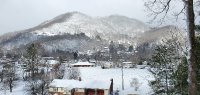
Maggie Valley Steve replied to Buckethead's topic in Southeastern States
Morning pictures. -
2024-2025 Fall/Winter Mountain Thread
Maggie Valley Steve replied to Buckethead's topic in Southeastern States
Measured 3 inches on the back deck, but I know a lot melted, compacted and a layer of sleet. The driveway is a sheet of ice. Cataloochee is reporting 7 inches at 6:45 this morning. Soco Rd is open in town. -
2024-2025 Fall/Winter Mountain Thread
Maggie Valley Steve replied to Buckethead's topic in Southeastern States
I know they closed it from the Pkwy thru the reservation this morning at 8. Our intention was to turn around at the Pkwy, but unfortunately folks from out of town obviously thought they could make with 2 wheel drive...lol -
2024-2025 Fall/Winter Mountain Thread
Maggie Valley Steve replied to Buckethead's topic in Southeastern States
I know I busted on my call. Wx Knurd has a point though. We tried to get up to Soco Gap this afternoon, but unfortunately there were too many 2 wheel drive folks up ahead of us spinning all over the road, so we turned back. I bet the totals up there are respectable. It will be interesting to see what Cataloochee ends with tomorrow morning. I strongly believe we are not done yet. Next week is looking intriguing and even beyond. The CPC is honking on the cold with moisture continuing for the next couple of weeks. I guess we'll see! -
2024-2025 Fall/Winter Mountain Thread
Maggie Valley Steve replied to Buckethead's topic in Southeastern States
Back to mostly moderate to at times heavy snow mixed with some sleet. The wind is very brisk out there now. -
2024-2025 Fall/Winter Mountain Thread
Maggie Valley Steve replied to Buckethead's topic in Southeastern States
Yeah, as soon as the wind started howling down the Valley, sleet let up. The driveway caved badly even with salt down. -
2024-2025 Fall/Winter Mountain Thread
Maggie Valley Steve replied to Buckethead's topic in Southeastern States
Back to all snow after a heavy sleet shower. Winds are picking up and the temperature has dropped back to 30°. -
2024-2025 Fall/Winter Mountain Thread
Maggie Valley Steve replied to Buckethead's topic in Southeastern States
New Mesoscale Discussion.... -
2024-2025 Fall/Winter Mountain Thread
Maggie Valley Steve replied to Buckethead's topic in Southeastern States
Just got in from riding all over Maggie Valley, up toward Soco Gap and Cataloochee. Met1985 and I got to experience everything the past couple of hours to rain/snow, sleet/snow and now huge flakes near silver dollars. Back at the house and I have heavy snow with less than a quarter mile visibility! -
2024-2025 Fall/Winter Mountain Thread
Maggie Valley Steve replied to Buckethead's topic in Southeastern States
Temperature here is up to 34. Just very tiny flakes, but radar indicates we'll fill back in shortly. -
2024-2025 Fall/Winter Mountain Thread
Maggie Valley Steve replied to Buckethead's topic in Southeastern States
I got salt down on the driveway 45 minutes ago. Now moderate nickels and quarters falling. Visibility down less than a mile. -
2024-2025 Fall/Winter Mountain Thread
Maggie Valley Steve replied to Buckethead's topic in Southeastern States
Ceiling has lowered significantly, light to moderate snow at Cataloochee. Flurries just began at the house. -
2024-2025 Fall/Winter Mountain Thread
Maggie Valley Steve replied to Buckethead's topic in Southeastern States
Up to 27 now. Definitely virga overhead and the ceiling is lowering. It appears that light snow is beginning to fall at higher elevations of the Balsams. It shouldn't be long here before light snow begins. -
2024-2025 Fall/Winter Mountain Thread
Maggie Valley Steve replied to Buckethead's topic in Southeastern States
Reports than snow has started at DT Chattanooga. -
2024-2025 Fall/Winter Mountain Thread
Maggie Valley Steve replied to Buckethead's topic in Southeastern States
Waking up to 26. GSP increased my point and click forecast by an inch or two with no suggested mixing issues. -
1/10-11 super awesome winter SE OBS thread
Maggie Valley Steve replied to strongwxnc's topic in Southeastern States
19° currently with 1 inch of snow on the ground from last Sunday night. -
2024-2025 Fall/Winter Mountain Thread
Maggie Valley Steve replied to Buckethead's topic in Southeastern States
Where's Buckethead? -
2024-2025 Fall/Winter Mountain Thread
Maggie Valley Steve replied to Buckethead's topic in Southeastern States
Down to 21 after a high of 28 here. I still have an inch of snow on the ground from Sunday night/Monday morning. NW Gulf low is cranking up. Time to watch the radar folks. -
2024-2025 Fall/Winter Mountain Thread
Maggie Valley Steve replied to Buckethead's topic in Southeastern States
Man, that would likely bring some 10+ amounts in the jackpot zone! Good luck gang! It's been fun tracking the past couple of weeks and if the medium/long range guidance is correct, we'll be doing it again shortly! -
Refresh your browser. They've updated.
-
2024-2025 Fall/Winter Mountain Thread
Maggie Valley Steve replied to Buckethead's topic in Southeastern States
If I was 15 years younger, I'd be right there with you! Good to see you back WxKnurd! -
2024-2025 Fall/Winter Mountain Thread
Maggie Valley Steve replied to Buckethead's topic in Southeastern States
Starting the day with 11° and clear.


