
Maggie Valley Steve
-
Posts
866 -
Joined
-
Last visited
Content Type
Profiles
Blogs
Forums
American Weather
Media Demo
Store
Gallery
Everything posted by Maggie Valley Steve
-

2024-2025 Fall/Winter Mountain Thread
Maggie Valley Steve replied to Buckethead's topic in Southeastern States
We've really dodged a bullet today here in the Valley. It's been fluctuating between light to moderate rain the past couple of hours and still stuck at 33. The ground is really saturated now. Fingers and toes crossed that flooding issues do not become a reality. -
2024-2025 Fall/Winter Mountain Thread
Maggie Valley Steve replied to Buckethead's topic in Southeastern States
33 and rain at the house. -
2024-2025 Fall/Winter Mountain Thread
Maggie Valley Steve replied to Buckethead's topic in Southeastern States
Starting the day at 37. -
2024-2025 Fall/Winter Mountain Thread
Maggie Valley Steve replied to Buckethead's topic in Southeastern States
Down to 36 at the house. Cataloochee is reporting 29 now. -
2024-2025 Fall/Winter Mountain Thread
Maggie Valley Steve replied to Buckethead's topic in Southeastern States
The Mountains are now in the Heavy Rainfall area in the Updated WPC Hazard Outlook.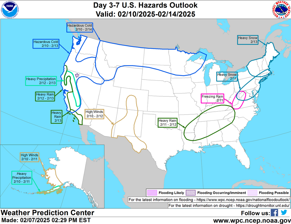
-
2024-2025 Fall/Winter Mountain Thread
Maggie Valley Steve replied to Buckethead's topic in Southeastern States
It's beginning to look like we may have a potential for flooding next week particularly Tuesday through Thursday. Something to keep an eye on. -
2024-2025 Fall/Winter Mountain Thread
Maggie Valley Steve replied to Buckethead's topic in Southeastern States
What a glorious 'false spring' day in the Mountains! I hit 66 today which is the highest temperature since last December. Tomorrow looks even warmer and will be a perfect day for a motorcycle ride! -
2024-2025 Fall/Winter Mountain Thread
Maggie Valley Steve replied to Buckethead's topic in Southeastern States
36 this morning and the ground is wet. It was too warm here last night for snow I believe. -
2024-2025 Fall/Winter Mountain Thread
Maggie Valley Steve replied to Buckethead's topic in Southeastern States
Flurries at the house now. -
2024-2025 Fall/Winter Mountain Thread
Maggie Valley Steve replied to Buckethead's topic in Southeastern States
Just checked the Webcam at Hemphill Bald. Flurries are falling with decent sized flakes. -
2024-2025 Fall/Winter Mountain Thread
Maggie Valley Steve replied to Buckethead's topic in Southeastern States
16 with some clouds moving in. The trajectory seems more W to WNW looking at radar upstream. Maybe we'll see some flurries later this morning. -
2024-2025 Fall/Winter Mountain Thread
Maggie Valley Steve replied to Buckethead's topic in Southeastern States
I had a low of 15 this morning. Looks like we'll get a light upslope snow tomorrow morning and perhaps a wintry mix early Monday morning. -
2024-2025 Fall/Winter Mountain Thread
Maggie Valley Steve replied to Buckethead's topic in Southeastern States
I want to share this here in our group. This Winter Storm crushed records! My morning email from my buddy Jeff Lindner: Yesterday, January 21, 2025 resulted in one of the most significant and historic snow events along the US Gulf coast since 1895. Heavy snow occurred from the Houston metro area along the entire Gulf coast to FL. Data is still being complied to determine the historical context of this event but some areas in Louisiana and Florida have confirmed the exceedance of their all-time record snow amounts. In Addition to the snow, temperatures this morning across this snowpack have fallen to “all-time” records many of which were held from 1899. The numbers listed below are preliminary and subject to change when full data sets are examined. The 1.2 inches of snow recorded at BUSH IAH did not break the record of 3.0 inches from 1960. Note snowfall totals can varying greatly over short distances. Southeast Texas Snowfall Totals: LaPorte: 6.0 Baytown: 5.5 Beaumont: 5.2 Anahuac: 5.0 Dayton: 5.0 Stafford: 4.5 Crosby: 4.5 Cove: 4.5 Al Lago: 4.2 Deer Park: 4.0 Richmond: 4.0 Cleveland: 4.0 Spring Branch: 3.0 South Houston: 3.0 Bellaire: 3.0 Santa Fe: 3.0 Hobby Airport: 3.0 Santa Fe: 3.0 Pearland: 3.0 Dickinson: 3.2 West University: 3.3 Conroe: 2.5 Brookshire: 2.5 Jersey Village: 2.5 Bunker Hill Village: 2.9 Cat Spring: 2.0 Bellville: 2.0 Lake Jackson: 2.0 San Leon: 2.0 Livingston: 2.0 BUSH IAH: 1.2 Tomball: 1.5 Brenham: 1.0 Galveston Island: 1.0 Other Snowfall Totals: Chalmette: 11.0 Metairie: 10.0 New Orleans: 9.8 (broke all-time record of 8.2 from 1895) Lafayette: 9.5 Milton, FL: 8.8 (broke the FL state all-time record of 4.0 inches in 1954) Biloxi: 7.8 Baton Rouge: 7.6 Mobil: 7.5 Orange Beach: 6.5 Lake Charles: 6.0 Pensacola: 5.0 Historic Low Temperatures (so far this morning): New Iberia, LA: 1 (shatters all-time record of 9 from 1962) Lafayette, LA: 4 (broke all-time record of 6 from 1899) Lake Charles: 6 (all-time record is 3 from 1899) Beaumont: 8 (broke all-time record of 10 from 1906) Jeff Lindner Director Hydrologic Operations Division/Meteorologist Harris County Flood Control District -
2024-2025 Fall/Winter Mountain Thread
Maggie Valley Steve replied to Buckethead's topic in Southeastern States
Congratulations Don! Thanks for sharing! -
2024-2025 Fall/Winter Mountain Thread
Maggie Valley Steve replied to Buckethead's topic in Southeastern States
I dropped to 4 at 6:45 this morning. -
2024-2025 Fall/Winter Mountain Thread
Maggie Valley Steve replied to Buckethead's topic in Southeastern States
Light flurries at the house. -
2024-2025 Fall/Winter Mountain Thread
Maggie Valley Steve replied to Buckethead's topic in Southeastern States
Flurries at Cataloochee now. -
2024-2025 Fall/Winter Mountain Thread
Maggie Valley Steve replied to Buckethead's topic in Southeastern States
Flurries up at Hemphill Bald. -
2024-2025 Fall/Winter Mountain Thread
Maggie Valley Steve replied to Buckethead's topic in Southeastern States
Getting virga showers moving over the mountains now. -
1/21 - 1/22 Winter Storm Threat
Maggie Valley Steve replied to TullyHeel's topic in Southeastern States
Reports I'm seeing suggests accumulations are increasing and virtually all of the freeway systems are snow covered. Snow is covering Seawall Blvd in Galveston at this time. A friend in Beaumont is reporting 3 inches and moderate snow. Jefferson County is under it's first Blizzard Warning since records have been kept back to the late 1800's, -
2024-2025 Fall/Winter Mountain Thread
Maggie Valley Steve replied to Buckethead's topic in Southeastern States
It was 10 at 3:30 this morning and has warned to a very balmy 13. There is a awfully thick cloud cover over the mountains. Virga watch today! -
2024-2025 Fall/Winter Mountain Thread
Maggie Valley Steve replied to Buckethead's topic in Southeastern States
Very likely. Models now will adjust to the ground truth of the precipitation organizing to our West. I wouldn't be surprised to see further changes with the 6Z and 12Z outputs tomorrow morning. It's down to 10 at the house now. -
2024-2025 Fall/Winter Mountain Thread
Maggie Valley Steve replied to Buckethead's topic in Southeastern States
The mission earlier will be ingested into the 00Z model output. I can report that snow has started all across all of SETX and back to San Antonio. -
2024-2025 Fall/Winter Mountain Thread
Maggie Valley Steve replied to Buckethead's topic in Southeastern States
They will be flying again for the 12Z output. -
2024-2025 Fall/Winter Mountain Thread
Maggie Valley Steve replied to Buckethead's topic in Southeastern States
Looks like an inch will be my total for this event. The wind likely cut down on what I could actually measure. This time the trees have a plaster on the N and W facing sides. Diamond Dust still lightly falling. Cataloochee did not post their overnight snowfall, but snow guns are blowing in the lower section of the Mountain.


