.jpg.b9a795a9fe89b3aa2ead015665ae36fe.jpg)
nvck
-
Posts
384 -
Joined
-
Last visited
Content Type
Profiles
Blogs
Forums
American Weather
Media Demo
Store
Gallery
Everything posted by nvck
-
76mph gust at KDAY
-
trending very unfavorably for central MI to get much of anything other than maybe a light glaze, and a couple inches of snow. sad
-
this is why, IMO, northern high plains is one of the best chasing regions in the country. sure the road networks are pretty sparse, but there's a fraction of the chasers as in the midwest/south plains, and the structure is insane.
-
Quick edit from pontiac, also got a ton of shots from this storm with my film camera, which'll be neat to get developed
- 309 replies
-
- 10
-

-
Potential for an ice storm in lower MI seems high, a few runs of the euro have highlighted a swath of totals close to an inch somewhere in the middle of the LP
-
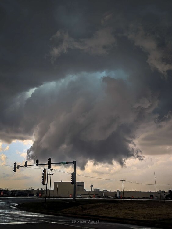
gif i made of some stills from a ~90sec video of the tornado in wheatfield yesterday. this was about 4 miles ESE of the city, looking northwest. the lightning was frequent enough to be able to pull a good amount of frames.

- 309 replies
-
- 11
-
-
I know some people doing research w/ lake-breeze fronts and their influence on CI, this could be really useful for a case study
-
funnily enough, we did almost exactly the same thing. Got to Pontiac well before CI, hung out for a while and watched as that cell came up from the SW, went west of town and chased it through town. Didn't see the ground circulation on the touchdown, but wow that was some incredible motion on the wall cloud. Thought for sure it'd drop something big. Followed it east to Emington, and then the people I was chasing with wanted to head west, waiting for the Peoria cells to pop off. After getting back to Pontiac, we saw that cell really ramp back up on radar and absolutely booked it east, intercepting near Wichert IL, except by that point it was completely rain-wrapped, and we couldn't get ahead of it, so just followed it a few miles to the south until we finally got a couple miles east, where we saw the Wheatfield and Knox tornadoes. So no, missed the big Kankakee tor and mega-hail. Also missed the Lake Village tor (although we almost drove into it)
-
Also what I've heard from Kankakee from my friends who chased there was that a lot of chasers got kinda caught out, large/giant hail was being flung around, and smashing cars, lot of damage in those neighborhoods
-
This was the Toto/Knox IN tor-e, just a screenshot from a video but not great quality.

-
Damn, was headed that way but couldn't get in ahead of the cell so bailed south.
-
Pic?
-
Was on that Pontiac cell as it went through town and made some stupid decisions and went back west after it seemingly elevated. Heading east towards IKK now, reports are appreciated if you've got a live view of it
-
Feeling p good, especially with the WF staying a couple dozen miles north. Hopefully ci in the next hour/two, don't really wanna chase after dark
-
That checks, im heading to Pontiac but Ik people who were targeting Kankakee and are repositioning sw
-
Think wf might be going back south through the IKK metro? Someone's PWS on the north side had a drop from 68 to 48 in 30 minutes
-
hrrr finally got on board with the earlier/afternoon CI that other cams have had. probably targeting bloomington initially? maybe a bit north (like pontiac) as that seems to be the trend
-
looking good for a chase tomorrow, HRRR has 4.2k surface CAPE in IL which is just unreal... agreed that the biggest question is just whether storms pop or not before 00/01z, to actually be able to see something while chasing
-
The CSUMLP giveth, and the CSUMLP taketh
-
southwest michigan tomorrow looks pretty interesting, i can't lie
-
-
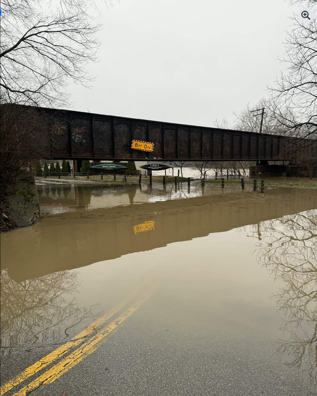
dealing with some flooding back home; don't think this bridge has an 8' clearance anymore!

-
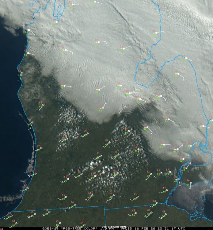
looks like tonights event will be too far south for us to get anything more than an inch or 2 up here, but will be nice to see flakes fly (for what may be the last/2nd to last time?)
-
.thumb.jpg.ad3a2e31d30aff035044689b311a0540.jpg)
Winter 2025-26 Medium/Long Range Discussion
nvck replied to michsnowfreak's topic in Lakes/Ohio Valley
next sun/mon/tues period is looking interesting? recent ensembles seem to have trended south some, maybe one last gasp of winter back home before a week in the 60s -
worst weather. rain this morning melted all the remaining snow, and now we're stuck in the upper 30s while GRR hits 60...