.jpg.93eb8afe5d1df4d67bc0eeb78d645380.jpg)
.jpg.7cbeb4b469bd18d447fac5868c43a091.jpg)
Yardstickgozinya
-
Posts
1,534 -
Joined
Content Type
Profiles
Blogs
Forums
American Weather
Media Demo
Store
Gallery
Everything posted by Yardstickgozinya
-
.thumb.jpg.6a4895b2a43f87359e4e7d04a6fa0d14.jpg)
Central PA Spring 2026 Discussion/Obs Thread
Yardstickgozinya replied to Voyager's topic in Upstate New York/Pennsylvania
Thank you @Jns2183. I originally missed the post with the rbr files. I'll definitely be checking those out over the next couple nights. -
Central PA Spring 2026 Discussion/Obs Thread
Yardstickgozinya replied to Voyager's topic in Upstate New York/Pennsylvania
I appreciate that and I do.I'll put something together for you. If you ever want to build a system, my son's been going down to Maryland and bringing back the newest generation.o AMD ryzen 7's and trident 75neo RGB sticks at ridiculous prices. I think you could put one together there for nearly half the price. You have to drive down there though, they won't sell it to you for their lowest price online for some reason. I'm actually hoping to head down there later this spring, after I get some mulching in. I'm hoping to put together a gaming and editing pc before ram gets any more out of control. The more you buy, the cheaper it gets. Unless we destabilize , this will probably be my last post for the day.I probably wore my welcome out with some of these guys before the sun even came up. -
Central PA Spring 2026 Discussion/Obs Thread
Yardstickgozinya replied to Voyager's topic in Upstate New York/Pennsylvania
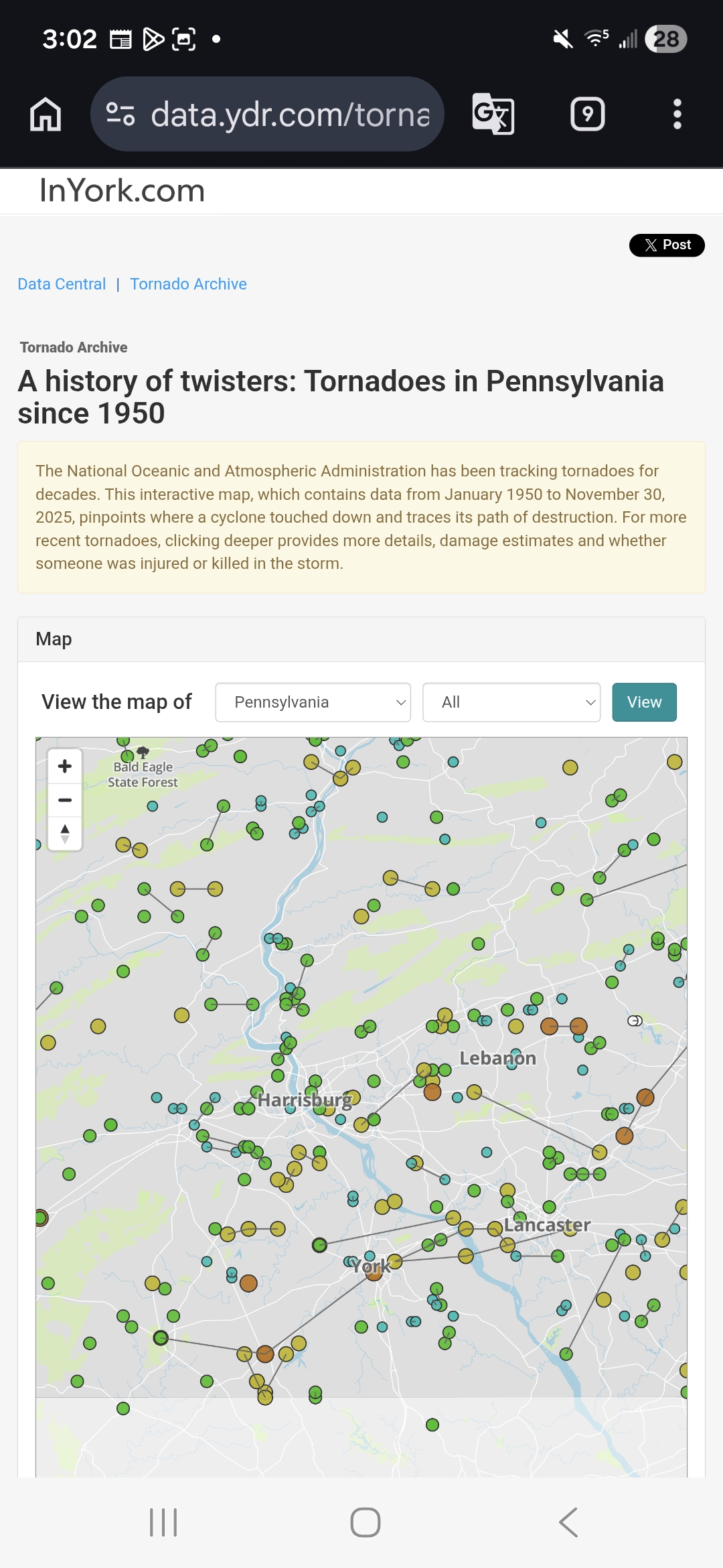
Link below https://data.ydr.com/tornado-archive/
-
Central PA Spring 2026 Discussion/Obs Thread
Yardstickgozinya replied to Voyager's topic in Upstate New York/Pennsylvania
I don't remember anymore if it was 2011 but it was some where around those years. There was a confirmed F1 on Darry street down twards the home depot. -
Central PA Spring 2026 Discussion/Obs Thread
Yardstickgozinya replied to Voyager's topic in Upstate New York/Pennsylvania
Sunday, I'll have to tell a story about when I beat him in a race -
Central PA Spring 2026 Discussion/Obs Thread
Yardstickgozinya replied to Voyager's topic in Upstate New York/Pennsylvania
Legend -
Central PA Spring 2026 Discussion/Obs Thread
Yardstickgozinya replied to Voyager's topic in Upstate New York/Pennsylvania
I'm starting to see imaginary tornadoes, float by. -
Central PA Spring 2026 Discussion/Obs Thread
Yardstickgozinya replied to Voyager's topic in Upstate New York/Pennsylvania
I guarantee it.I've talked about it before and someone else here also remembers that storm, one of our members is from hershey. I'm gonna pay for a membership one day, so I can put up videos . I have hershey storm on video. I believe it knocked down a bunch of the kiss light poles.If I remember correctly. -
Central PA Spring 2026 Discussion/Obs Thread
Yardstickgozinya replied to Voyager's topic in Upstate New York/Pennsylvania
They're few and far between, but we've had some really nasty ones out this way, but nothing super nasty since 2011 locally. There was several the big events from the mid eighties into the early 90s. I'll send you pm with some bangers, you might be able to find some information on. I've already mentioned the low dew point derecho and serial duratio of 89, several times on here. Another one, you might be able to find some history Is the 1988 big 33 Thunderstorm. Not only did it end the big 33 game early, but it injured several kids and knocked down numerous trees at the old outdoor Ymca pool and camp that used to be here in Fairview, township. I remember this one specifically because I was at that game to see some dude named Rocket Ismail. Lol Maryland 13 - Pennsylvania 21 Mother Nature forced an early ending to what might have been the most exciting Big 33 Classic in the long history of the all-star football series. Pennsylvania was declared a 21-13 winner over Maryland in a game that was halted at half-time by a violent thunderstorm. Most of the crowd of 17,334 were well on their way home when game director Mickey Minnich told coaches and players that it would be impossible to resume the action. It was a disappointing ending to what had been an exciting game. Players from both teams said they wish they had been able to return to action. -
Central PA Spring 2026 Discussion/Obs Thread
Yardstickgozinya replied to Voyager's topic in Upstate New York/Pennsylvania
2011 was also the year that a completely unexpected severe nocturnal, storm erupted over Hershey, and sat over top of them forever, dumping rain. It produced this extremely loud growling thunder. Eventually it collapsed exactly where it had formed and caused quite a bit of damage. It was one of the best lightning storms i've ever seen and probably had the most powerful strokes of any storm that i've ever witnessed. It was surveyed for a tornado, but it was verified as down drafts.'s . A few weeks before that a early morning storm unexpectedly erupted over. palmyra (could be wrong town) that rocked the whole area and made the news just like the Hershey storm for being so obnoxiously loud. It sat for for a well over an hour before it collapsed, I don't think it did as extensive damage as the Hershey storm. -
Central PA Spring 2026 Discussion/Obs Thread
Yardstickgozinya replied to Voyager's topic in Upstate New York/Pennsylvania
Sun is baking here.I'm not so sure we're done yet. -
Central PA Spring 2026 Discussion/Obs Thread
Yardstickgozinya replied to Voyager's topic in Upstate New York/Pennsylvania
I got it pretty good as far as garden variety thunderstorm. Heavy rain for about 20 minutes ,six or seven strokes of lightning, and maybe 20 mile per hour gust. -
Central PA Spring 2026 Discussion/Obs Thread
Yardstickgozinya replied to Voyager's topic in Upstate New York/Pennsylvania
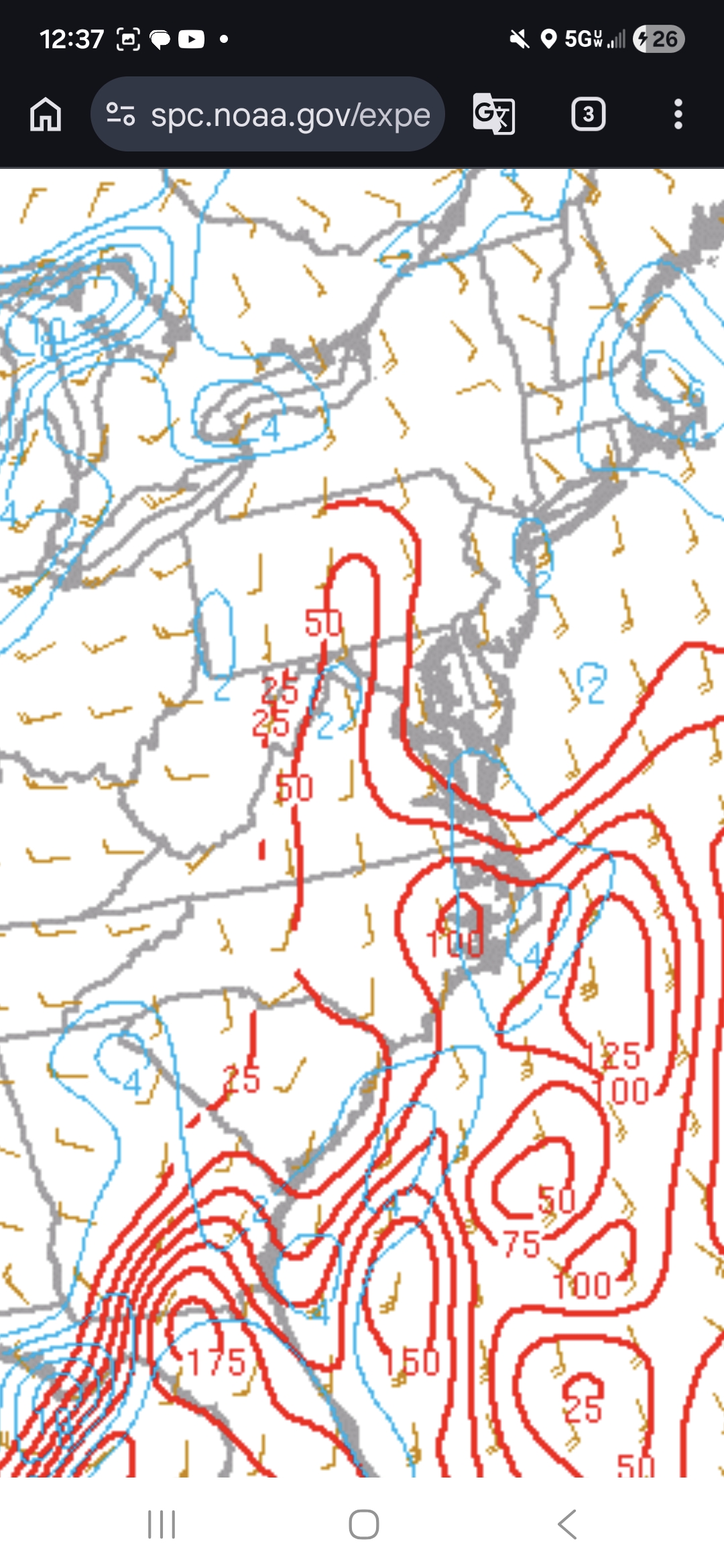
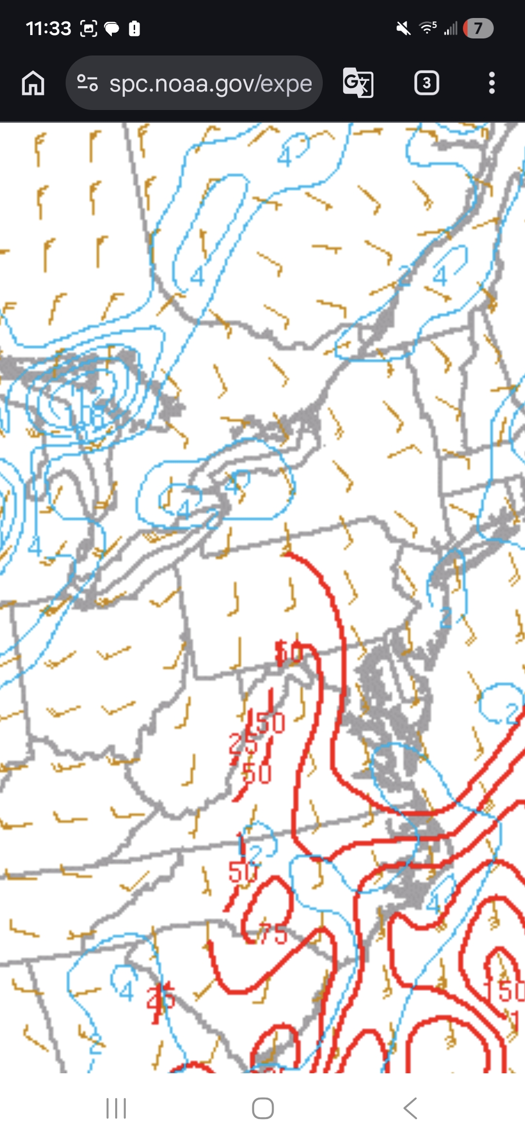
For anybody who's interested ,If you go back at the last graphic, I posted, and you look down at the Florida panhandle, you'll notice that vorticity, bullseye, of what appears to be 6 and 3 cape bullseye of 175kjg. If those two were to lineup over top of each other that's what you don't want to see . I'm not saying that that's what's going to happen down there.It's just close enough to overlapping to uses as an example. I realized that there's more than surface cape to be looking over but when you already know, you have everything else including the storm's that's where your eyes should be. -
Central PA Spring 2026 Discussion/Obs Thread
Yardstickgozinya replied to Voyager's topic in Upstate New York/Pennsylvania
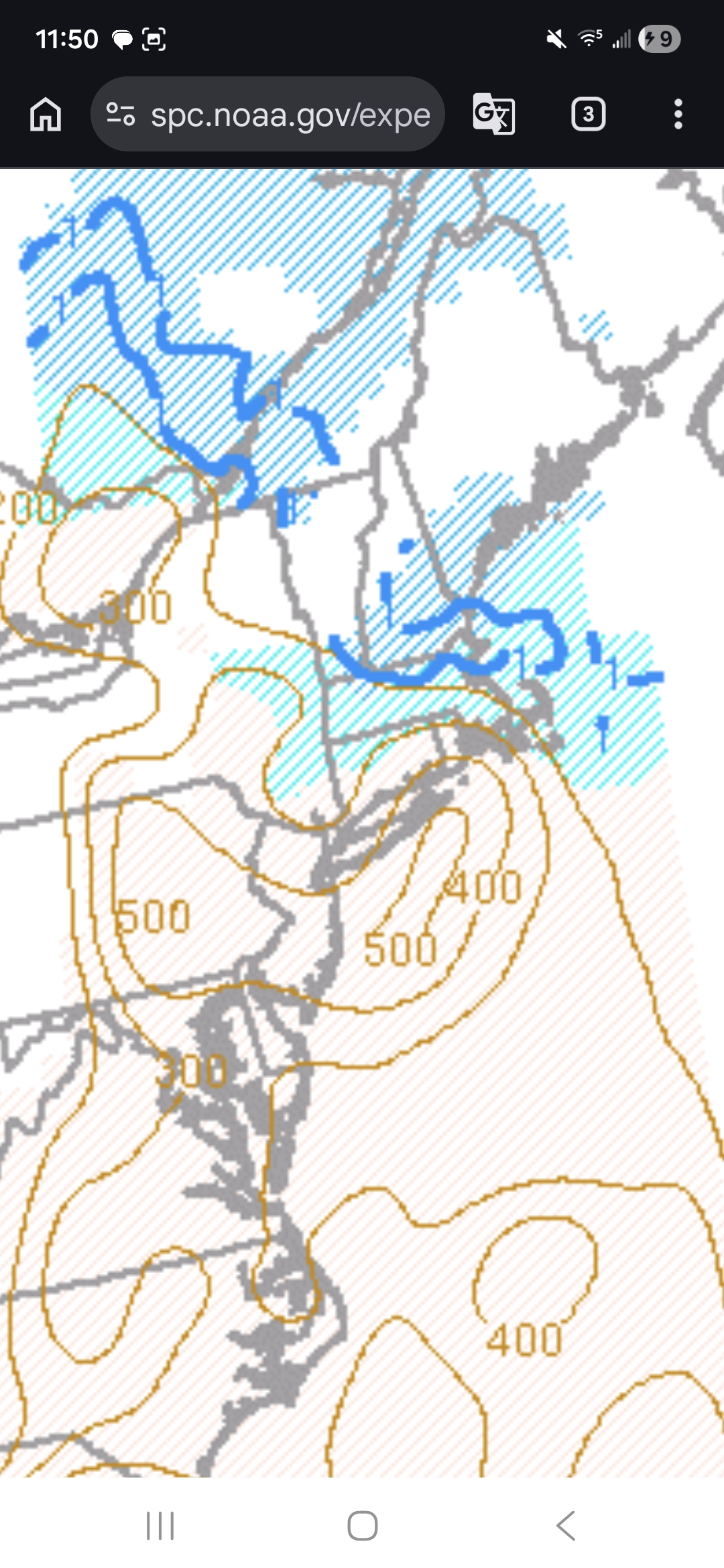
As I believe I mentioned earlier, fellows, there was some extra dynamics down there around Hagerstown MD area. They also now have an some vorticity but still pretty meager parameters at best. Some low 3 cape numbers are also still rising into Pennsylvania. I apologized, I said velocity earlier I ment vorticity.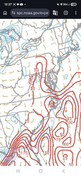
-
Central PA Spring 2026 Discussion/Obs Thread
Yardstickgozinya replied to Voyager's topic in Upstate New York/Pennsylvania
I was just thinking about this myself last night. Not all but some of the best thunderstorms i've experienced have came on days and nights when they're not even calling for for anythings due to lack of forcing mechanisms. Those are the days we bake and build cape under a weak cap until the afternoon. We actually also seem to be very prone to collapsing thunderstorms, in this general area and those can actually be fun. Lol -
Central PA Spring 2026 Discussion/Obs Thread
Yardstickgozinya replied to Voyager's topic in Upstate New York/Pennsylvania
We definitely had some enhanced downdraft cape build since I last checked this morning.
-
Central PA Spring 2026 Discussion/Obs Thread
Yardstickgozinya replied to Voyager's topic in Upstate New York/Pennsylvania
There is some surface Cape (3cape) of 50kjg out ahead of it, but luckily still no surface velocity. 50kjg 3 cape isn't much, but it is enough to spin up something small, especially if there's some enhanced surface velocity present. The carolinas are starting to show some week overlapping,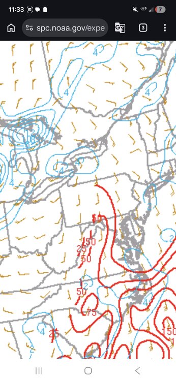
-
Central PA Spring 2026 Discussion/Obs Thread
Yardstickgozinya replied to Voyager's topic in Upstate New York/Pennsylvania
For convective weather I highly recommend convective chronicles and cameron nixon on youtube. I've been watching these guys for a while. I didn't really want to share them, but oh well. They both provide Meso scale and Skew T tutorials. No hype,and about as knowledgeable and willing to share for free as anyone on youtube. -
Central PA Spring 2026 Discussion/Obs Thread
Yardstickgozinya replied to Voyager's topic in Upstate New York/Pennsylvania
I absolutely agree and so do a growing number of other people and concernd mets. I guess I should add that his live storm coverage is beneficial, and I feel like that's what he should stick to. Unfortunately YouTube's and other social medias revenue sharing is intentionally not conducive to responsible and honest anything. Some people stay honest and responsible, regardless. Those mets are easy to find because they don't have nearly as many subscribers. -
Central PA Spring 2026 Discussion/Obs Thread
Yardstickgozinya replied to Voyager's topic in Upstate New York/Pennsylvania
-
Central PA Spring 2026 Discussion/Obs Thread
Yardstickgozinya replied to Voyager's topic in Upstate New York/Pennsylvania
Yeah, I don't know. Ryan is pretty universally considered the number one doomcaster. If you ask Ai to name you the top doomcasters, you should get a pretty universal answer. Both Max and Ryan came up in the top five every time. Professional mets seem to agree. Its really not something I care about that much. They haved changed the way everyone else has to present the weather and it's not for the best. -
Central PA Spring 2026 Discussion/Obs Thread
Yardstickgozinya replied to Voyager's topic in Upstate New York/Pennsylvania
I didn't even get started on Max.because I don't know where to start. A good place to start is with his youtube reviews, i'm not the only person that finds his b******* ridiculous. Monster bomb slammer jammer killer cyclones. -
Central PA Spring 2026 Discussion/Obs Thread
Yardstickgozinya replied to Voyager's topic in Upstate New York/Pennsylvania
I don't give those channels the time of day anymore but when I did watch them Andy seemed very professional.,Ryan has completely rewrote the book on weather hype and fear mongering. Intelligent guy for that guess. -
Central PA Spring 2026 Discussion/Obs Thread
Yardstickgozinya replied to Voyager's topic in Upstate New York/Pennsylvania
Yep, there's a lot of places like that, same with these YouTube Idiots like Ryan hall and Max velocity. They're f****** up everything. -
Central PA Spring 2026 Discussion/Obs Thread
Yardstickgozinya replied to Voyager's topic in Upstate New York/Pennsylvania
I'll make 80 different accounts until they change their f****** ways. Even if it takes me a year and nine months, just like it did here. That's why they couldn't accept any members.here for nearly a year few years ago. They told everybody it was a server issue.What a lot of people probably don't know Is that was actually just to keep me out because I would a f****** torn this place to pieces until the moderators changed their ways.